Author: Admiralty
Title: Nautical Chart No. 4936 Canada - British Columbia, Chatham Sound, Approaches to Prince Rupert Harbour
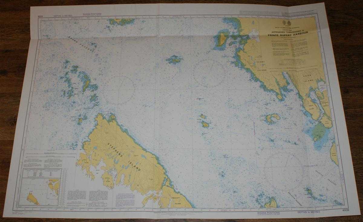
Description: Map Admiralty, 2005. Revised Edition, Softcover. Very Good Condition/No Dust Jacket. Crisp and clean colour chart with single horizontal and two vertical folds. Nautical Chart No. 4936 Canada - British Columbia, Chatham Sound, Approaches to Prince Rupert Harbour. Published 2005. Scale 1:40,000. Area Covered: North America (part), Canada (part), Stephens Island, Tree Nob Group, Lucy Islands, Archibald Islands, Rachael Islands, Kinahan Islands, Lawyer Islands, Tugwell Island, Prescott Island, Phillip Island, Joyce Island, Digby Island, Ridley Island. Brown Passage, Bell Passage, Skiakl Bay, Duncan Bay, Prince Rupert Harbour, Malacca Passage, Marcus Passage. Size: 84x119cm. Item Type: Map. Single sheet map/chart which is suitable for framing and will be shipped rolled and in a cardboard tube. Quantity Available: 1. Shipped Weight: under 1 kg. Pictures of this item not already displayed here available upon request. Inventory No: 45517104069. ISBN: 1870141156
Keywords: BZDB4 Maps; USA & Canada; naval, naval history, maritime, ships, boats. Admiralty Nautical Chart No. 4936 Canada - British Columbia, Chatham Sound, Approaches to Prince Rupert Harbour USA & Canada naval, naval history, maritime, ships, boats
See more books from our catalog: Maps
Title: Nautical Chart No. 4936 Canada - British Columbia, Chatham Sound, Approaches to Prince Rupert Harbour
Description: Map Admiralty, 2005. Revised Edition, Softcover. Very Good Condition/No Dust Jacket. Crisp and clean colour chart with single horizontal and two vertical folds. Nautical Chart No. 4936 Canada - British Columbia, Chatham Sound, Approaches to Prince Rupert Harbour. Published 2005. Scale 1:40,000. Area Covered: North America (part), Canada (part), Stephens Island, Tree Nob Group, Lucy Islands, Archibald Islands, Rachael Islands, Kinahan Islands, Lawyer Islands, Tugwell Island, Prescott Island, Phillip Island, Joyce Island, Digby Island, Ridley Island. Brown Passage, Bell Passage, Skiakl Bay, Duncan Bay, Prince Rupert Harbour, Malacca Passage, Marcus Passage. Size: 84x119cm. Item Type: Map. Single sheet map/chart which is suitable for framing and will be shipped rolled and in a cardboard tube. Quantity Available: 1. Shipped Weight: under 1 kg. Pictures of this item not already displayed here available upon request. Inventory No: 45517104069. ISBN: 1870141156
Keywords: BZDB4 Maps; USA & Canada; naval, naval history, maritime, ships, boats. Admiralty Nautical Chart No. 4936 Canada - British Columbia, Chatham Sound, Approaches to Prince Rupert Harbour USA & Canada naval, naval history, maritime, ships, boats
Price: GBP 26.00 = appr. US$ 37.13 Seller: Bailgate Books Ltd
- Book number: 45517104069
- Book number: 45517104069
See more books from our catalog: Maps