Author: Admiralty
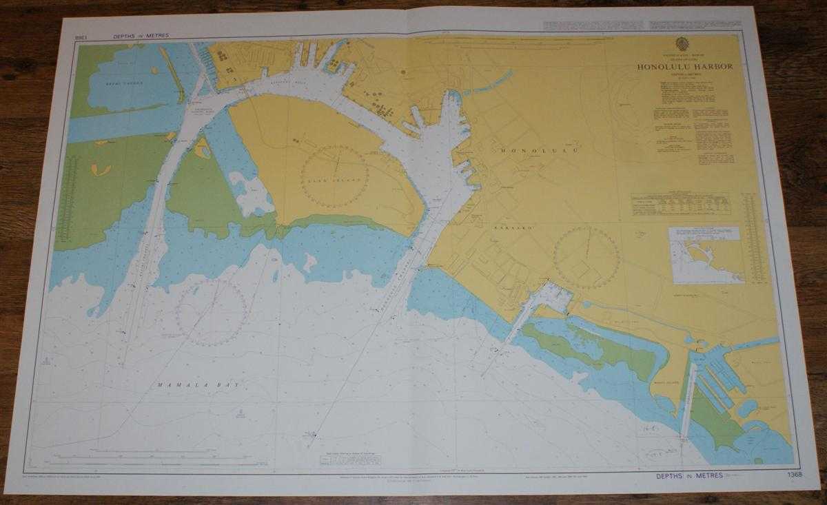
Title: Nautical Chart No. 1368 United States - Hawaii, Island of Oahu - Honolulu Harbour
Description: Map Admiralty, 2004. Revised Edition, Softcover. Very Good Condition/No Dust Jacket. Crisp and clean colour chart with single vertical fold. Some minor pencil annotation in bottom right portion of sheet. Nautical Chart No. 1368 United States - Hawaii, Island of Oahu - Honolulu Harbour. Copyright 1998 with small corrections to 2004. Scale 1:7,500. Area Covered: United States (part), Hawaii (part), Oahu (part), Honolulu, Kakaako, Sand Island, Keehi Lagoon, Mamala Bay, Kalihi Channel, Kapalama Basin, Honolulu Channel, Magic Island, Ala Wai Boat Harbour. Size: 72x104cm. Item Type: Map. Single sheet map/chart which is suitable for framing and will be shipped rolled and in a cardboard tube. Quantity Available: 1. Shipped Weight: under 1 kg. Pictures of this item not already displayed here available upon request. Inventory No: 45517104063. ISBN: 1870141156
Keywords: BZDB4 Maps; USA & Canada; Australasia and the Pacific; naval, naval history, maritime, ships, boats. Admiralty Nautical Chart No. 1368 United States - Hawaii, Island of Oahu - Honolulu Harbour USA & Canada Australasia and the Pacific naval, naval history
See more books from our catalog: Maps
Title: Nautical Chart No. 1368 United States - Hawaii, Island of Oahu - Honolulu Harbour
Description: Map Admiralty, 2004. Revised Edition, Softcover. Very Good Condition/No Dust Jacket. Crisp and clean colour chart with single vertical fold. Some minor pencil annotation in bottom right portion of sheet. Nautical Chart No. 1368 United States - Hawaii, Island of Oahu - Honolulu Harbour. Copyright 1998 with small corrections to 2004. Scale 1:7,500. Area Covered: United States (part), Hawaii (part), Oahu (part), Honolulu, Kakaako, Sand Island, Keehi Lagoon, Mamala Bay, Kalihi Channel, Kapalama Basin, Honolulu Channel, Magic Island, Ala Wai Boat Harbour. Size: 72x104cm. Item Type: Map. Single sheet map/chart which is suitable for framing and will be shipped rolled and in a cardboard tube. Quantity Available: 1. Shipped Weight: under 1 kg. Pictures of this item not already displayed here available upon request. Inventory No: 45517104063. ISBN: 1870141156
Keywords: BZDB4 Maps; USA & Canada; Australasia and the Pacific; naval, naval history, maritime, ships, boats. Admiralty Nautical Chart No. 1368 United States - Hawaii, Island of Oahu - Honolulu Harbour USA & Canada Australasia and the Pacific naval, naval history
Price: GBP 26.00 = appr. US$ 37.13 Seller: Bailgate Books Ltd
- Book number: 45517104063
- Book number: 45517104063
See more books from our catalog: Maps