Author: Admiralty
Title: Nautical Chart No. 1490 North Pacific Ocean - Harbours in the Hawaiian Islands
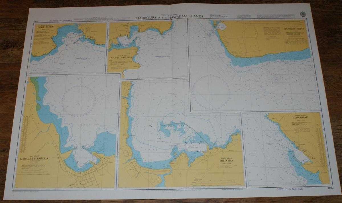
Description: Map Admiralty, 2004. Revised Edition, Softcover. Very Good Condition/No Dust Jacket. Crisp and clean colour chart with single vertical fold. Nautical Chart No. 1490 North Pacific Ocean - Harbours in the Hawaiian Islands. Copyright 1985 with small corrections to 2004. Sheet contains six separate charts: Kauai Island - Port Allen, at scale 1:10,000 Kauai Island - Nawiliwili Bay, at scale 1:15,000 Oahu Island - Barbers Point, at scale 1:25,000 Maui Island - Kahului Harbour, at scale 1:12,500 Hawaii Island - Hilo Bay, at scale 1:15,000 Hawaii Island - Kawaihae, at scale 1:15,000 Size: 72x104. Item Type: Map. Single sheet map/chart which is suitable for framing and will be shipped rolled and in a cardboard tube. Quantity Available: 1. Shipped Weight: under 1 kg. Pictures of this item not already displayed here available upon request. Inventory No: 45517104059. ISBN: 1870141156
Keywords: BZDB4 Maps; USA & Canada; Australasia and the Pacific; naval, naval history, maritime, ships, boats. Admiralty Nautical Chart No. 1490 North Pacific Ocean - Harbours in the Hawaiian Islands USA & Canada Australasia and the Pacific naval, naval history, m
See more books from our catalog: Maps
Title: Nautical Chart No. 1490 North Pacific Ocean - Harbours in the Hawaiian Islands
Description: Map Admiralty, 2004. Revised Edition, Softcover. Very Good Condition/No Dust Jacket. Crisp and clean colour chart with single vertical fold. Nautical Chart No. 1490 North Pacific Ocean - Harbours in the Hawaiian Islands. Copyright 1985 with small corrections to 2004. Sheet contains six separate charts: Kauai Island - Port Allen, at scale 1:10,000 Kauai Island - Nawiliwili Bay, at scale 1:15,000 Oahu Island - Barbers Point, at scale 1:25,000 Maui Island - Kahului Harbour, at scale 1:12,500 Hawaii Island - Hilo Bay, at scale 1:15,000 Hawaii Island - Kawaihae, at scale 1:15,000 Size: 72x104. Item Type: Map. Single sheet map/chart which is suitable for framing and will be shipped rolled and in a cardboard tube. Quantity Available: 1. Shipped Weight: under 1 kg. Pictures of this item not already displayed here available upon request. Inventory No: 45517104059. ISBN: 1870141156
Keywords: BZDB4 Maps; USA & Canada; Australasia and the Pacific; naval, naval history, maritime, ships, boats. Admiralty Nautical Chart No. 1490 North Pacific Ocean - Harbours in the Hawaiian Islands USA & Canada Australasia and the Pacific naval, naval history, m
Price: GBP 26.00 = appr. US$ 37.13 Seller: Bailgate Books Ltd
- Book number: 45517104059
- Book number: 45517104059
See more books from our catalog: Maps