Author: Admiralty
Title: Nautical Chart No. 3865 West Indies - Cuba, Eastern Sheet
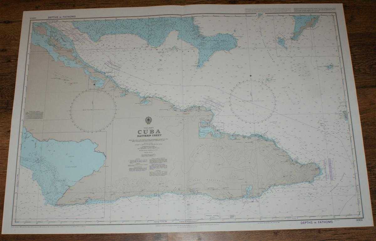
Description: Map Admiralty, 2001. Revised Edition, Softcover. Very Good Condition/No Dust Jacket. Crisp and clean colour chart with single vertical fold. Nautical Chart No. 3865 West Indies - Cuba, Eastern Sheet. Copyright 1989 with small corrections to 2001. Scale 1:500,000. Area Covered: Cuba (part), Cabo Cruz, Puerto Santiago de Cuba, Guantanamo Bay, Punta Maisi, Levisa, Banes, Puerto Padre, Manati, Cayo Sabinal, Cayo Romano, Acklins Island. Golfo de Guacanayabo, Great Bahama Bank, Crooked Island Passage, Windward Passage, Old Bahama Channel, Columbus Bank. Size: 72x104cm. Item Type: Map. Quantity Available: 1. Shipped Weight: under 1 kg. Pictures of this item not already displayed here available upon request. Inventory No: 45517094049. ISBN: 1859831060
Keywords: BZDB4 Maps; naval, naval history, maritime, ships, boats; South & Central America & the West Indies. Admiralty Nautical Chart No. 3865 West Indies - Cuba, Eastern Sheet naval, naval history, maritime, ships, boats South & Central America & the West Indi
See more books from our catalog: Maps
Title: Nautical Chart No. 3865 West Indies - Cuba, Eastern Sheet
Description: Map Admiralty, 2001. Revised Edition, Softcover. Very Good Condition/No Dust Jacket. Crisp and clean colour chart with single vertical fold. Nautical Chart No. 3865 West Indies - Cuba, Eastern Sheet. Copyright 1989 with small corrections to 2001. Scale 1:500,000. Area Covered: Cuba (part), Cabo Cruz, Puerto Santiago de Cuba, Guantanamo Bay, Punta Maisi, Levisa, Banes, Puerto Padre, Manati, Cayo Sabinal, Cayo Romano, Acklins Island. Golfo de Guacanayabo, Great Bahama Bank, Crooked Island Passage, Windward Passage, Old Bahama Channel, Columbus Bank. Size: 72x104cm. Item Type: Map. Quantity Available: 1. Shipped Weight: under 1 kg. Pictures of this item not already displayed here available upon request. Inventory No: 45517094049. ISBN: 1859831060
Keywords: BZDB4 Maps; naval, naval history, maritime, ships, boats; South & Central America & the West Indies. Admiralty Nautical Chart No. 3865 West Indies - Cuba, Eastern Sheet naval, naval history, maritime, ships, boats South & Central America & the West Indi
Price: GBP 26.00 = appr. US$ 37.13 Seller: Bailgate Books Ltd
- Book number: 45517094049
- Book number: 45517094049
See more books from our catalog: Maps