Author: Admiralty
Title: Nautical Chart No. 3802 Cuba - South Coast, Golfo de Guacanayabo, Punta Gua to Santa Cruz del Sur
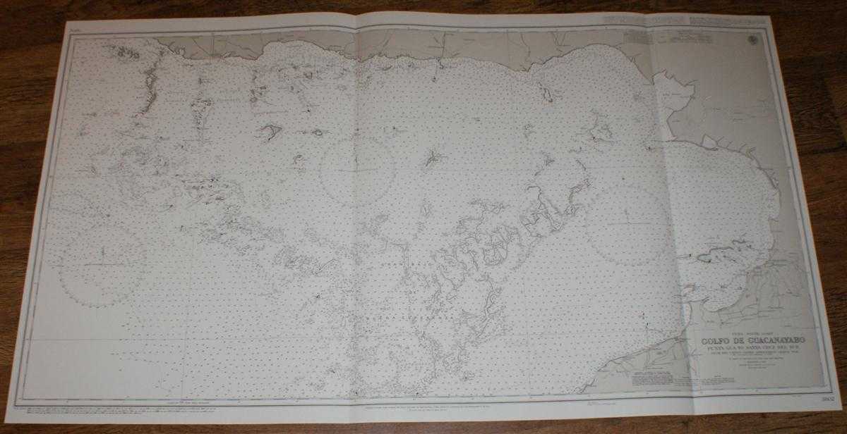
Description: Map Admiralty, 2000. Revised Edition, Softcover. Very Good Condition/No Dust Jacket. Crisp and clean black and white chart with two vertical folds. Nautical Chart No. 3802 Cuba - South Coast, Golfo de Guacanayabo, Punta Gua to Santa Cruz del Sur. Copyright 1963 with small corrections to 2000. Scale 1:100,000. Area Covered: Cuba (part), Cayos Mate, San Juan Anchorage, Canal Meia Luna, Canal de Cuatro Reales, Cayo Rabihorcado, Gran Bajo de Buena Esperanza, Canal Pitajaya, Cayos de Manzanillo, Campechuela, Calicito, Manzanillo, Rio Cauto, Bahia Birama, Cayos Sevilla, Paso Chinchorro, Santa Cruz del Sur Size: 72x124. Item Type: Map. Quantity Available: 1. Shipped Weight: under 1 kg. Pictures of this item not already displayed here available upon request. Inventory No: 45517094048. ISBN: 1859831060
Keywords: BZDB4 Maps; naval, naval history, maritime, ships, boats; South & Central America & the West Indies. Admiralty Nautical Chart No. 3802 Cuba - South Coast, Golfo de Guacanayabo, Punta Gua to Santa Cruz del Sur naval, naval history, maritime, ships, boats
See more books from our catalog: Maps
Title: Nautical Chart No. 3802 Cuba - South Coast, Golfo de Guacanayabo, Punta Gua to Santa Cruz del Sur
Description: Map Admiralty, 2000. Revised Edition, Softcover. Very Good Condition/No Dust Jacket. Crisp and clean black and white chart with two vertical folds. Nautical Chart No. 3802 Cuba - South Coast, Golfo de Guacanayabo, Punta Gua to Santa Cruz del Sur. Copyright 1963 with small corrections to 2000. Scale 1:100,000. Area Covered: Cuba (part), Cayos Mate, San Juan Anchorage, Canal Meia Luna, Canal de Cuatro Reales, Cayo Rabihorcado, Gran Bajo de Buena Esperanza, Canal Pitajaya, Cayos de Manzanillo, Campechuela, Calicito, Manzanillo, Rio Cauto, Bahia Birama, Cayos Sevilla, Paso Chinchorro, Santa Cruz del Sur Size: 72x124. Item Type: Map. Quantity Available: 1. Shipped Weight: under 1 kg. Pictures of this item not already displayed here available upon request. Inventory No: 45517094048. ISBN: 1859831060
Keywords: BZDB4 Maps; naval, naval history, maritime, ships, boats; South & Central America & the West Indies. Admiralty Nautical Chart No. 3802 Cuba - South Coast, Golfo de Guacanayabo, Punta Gua to Santa Cruz del Sur naval, naval history, maritime, ships, boats
Price: GBP 26.00 = appr. US$ 37.13 Seller: Bailgate Books Ltd
- Book number: 45517094048
- Book number: 45517094048
See more books from our catalog: Maps