Author: Admiralty
Title: Nautical Chart No. 410 West Indies - Ports and Anchorages on the North Coast of Cuba
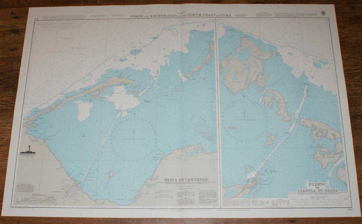
Description: Map Admiralty, 2001. Revised Edition, Softcover. Very Good Condition/No Dust Jacket. Crisp and clean colour chart with single vertical fold. Nautical Chart No. 410 West Indies - Ports and Anchorages on the North Coast of Cuba. Copyright 1998 with small corrections to 2001. Sheet is divided into two charts: Bahia de Cardenas at scale 1:50,000 and Puerto de Isabela de Sagua at scale 1:25,000 Area Covered: Cardenas, Peninsula de Hicacos, Cienaga del Bibanasi, Cayos Grupo de Blancos, Cayos Grupo de la Manuy, Punta Gorda del Este, La Isabela, Cayo Iguana, Cayo Cristo, Cayo Matahambre, Cayo Bicho, Cayo de la Cruz, Cayo Maravillas, Cayo Hachuela. Size: 72x104cm. Item Type: Map. Quantity Available: 1. Shipped Weight: under 1 kg. Pictures of this item not already displayed here available upon request. Inventory No: 45517094036. ISBN: 1859831060
Keywords: BZDB4 Maps; naval, naval history, maritime, ships, boats; South & Central America & the West Indies. Admiralty Nautical Chart No. 410 West Indies - Ports and Anchorages on the North Coast of Cuba naval, naval history, maritime, ships, boats South & Cent
See more books from our catalog: Maps
Title: Nautical Chart No. 410 West Indies - Ports and Anchorages on the North Coast of Cuba
Description: Map Admiralty, 2001. Revised Edition, Softcover. Very Good Condition/No Dust Jacket. Crisp and clean colour chart with single vertical fold. Nautical Chart No. 410 West Indies - Ports and Anchorages on the North Coast of Cuba. Copyright 1998 with small corrections to 2001. Sheet is divided into two charts: Bahia de Cardenas at scale 1:50,000 and Puerto de Isabela de Sagua at scale 1:25,000 Area Covered: Cardenas, Peninsula de Hicacos, Cienaga del Bibanasi, Cayos Grupo de Blancos, Cayos Grupo de la Manuy, Punta Gorda del Este, La Isabela, Cayo Iguana, Cayo Cristo, Cayo Matahambre, Cayo Bicho, Cayo de la Cruz, Cayo Maravillas, Cayo Hachuela. Size: 72x104cm. Item Type: Map. Quantity Available: 1. Shipped Weight: under 1 kg. Pictures of this item not already displayed here available upon request. Inventory No: 45517094036. ISBN: 1859831060
Keywords: BZDB4 Maps; naval, naval history, maritime, ships, boats; South & Central America & the West Indies. Admiralty Nautical Chart No. 410 West Indies - Ports and Anchorages on the North Coast of Cuba naval, naval history, maritime, ships, boats South & Cent
Price: GBP 26.00 = appr. US$ 37.13 Seller: Bailgate Books Ltd
- Book number: 45517094036
- Book number: 45517094036
See more books from our catalog: Maps