Author: Admiralty
Title: Nautical Chart No. 332 Bermuda Islands - Grassy Bay and Great Sound including Little Sound
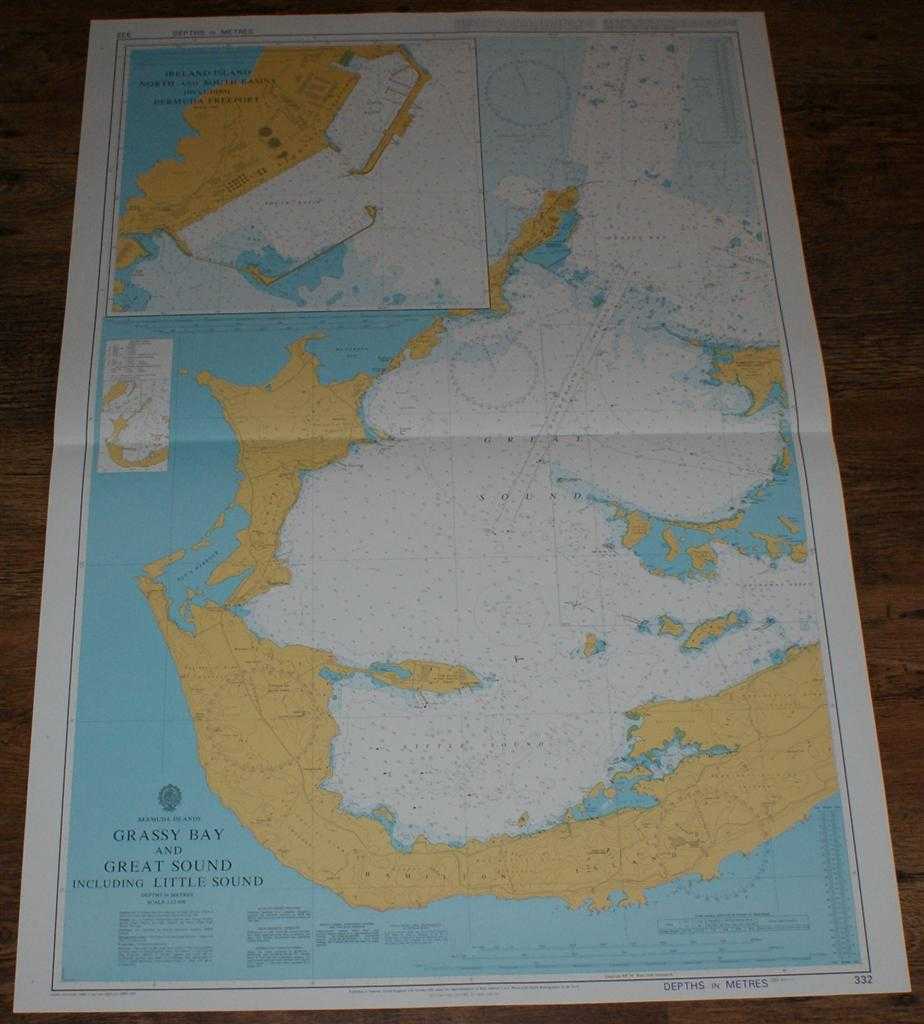
Description: Map Admiralty, 2001. Revised Edition, Softcover. Very Good Condition/No Dust Jacket. Crisp and clean colour chart with single horizontal fold. Nautical Chart No. 332 Bermuda Islands - Grassy Bay and Great Sound including Little Sound. Copyright 1993 with small corrections to 2001. Scale 1:12,500. Sheet contains inset chart of Ireland Island North and South Basins including Bermuda Freeport at scale 1:3,000. Area Covered: Hamilton Island (part), Somerset Island Boaz Ireland, Ireland Island, Hamilton Island Spanish Point, Hawkins Island, Darrel Island, Bermuda Freeport. Great Sound, Little Sound, Ely's Harbour, Mangrove Bay, Granaway Deep, Grassy Bay, Dundonald Channel. Size: 104x72cm. Item Type: Map. Quantity Available: 1. Shipped Weight: under 1 kg. Pictures of this item not already displayed here available upon request. Inventory No: 45517094010. ISBN: 1859831060
Keywords: BZDB4 Maps; naval, naval history, maritime, ships, boats; South & Central America & the West Indies. Admiralty Nautical Chart No. 332 Bermuda Islands - Grassy Bay and Great Sound including Little Sound naval, naval history, maritime, ships, boats South
See more books from our catalog: Maps
Title: Nautical Chart No. 332 Bermuda Islands - Grassy Bay and Great Sound including Little Sound
Description: Map Admiralty, 2001. Revised Edition, Softcover. Very Good Condition/No Dust Jacket. Crisp and clean colour chart with single horizontal fold. Nautical Chart No. 332 Bermuda Islands - Grassy Bay and Great Sound including Little Sound. Copyright 1993 with small corrections to 2001. Scale 1:12,500. Sheet contains inset chart of Ireland Island North and South Basins including Bermuda Freeport at scale 1:3,000. Area Covered: Hamilton Island (part), Somerset Island Boaz Ireland, Ireland Island, Hamilton Island Spanish Point, Hawkins Island, Darrel Island, Bermuda Freeport. Great Sound, Little Sound, Ely's Harbour, Mangrove Bay, Granaway Deep, Grassy Bay, Dundonald Channel. Size: 104x72cm. Item Type: Map. Quantity Available: 1. Shipped Weight: under 1 kg. Pictures of this item not already displayed here available upon request. Inventory No: 45517094010. ISBN: 1859831060
Keywords: BZDB4 Maps; naval, naval history, maritime, ships, boats; South & Central America & the West Indies. Admiralty Nautical Chart No. 332 Bermuda Islands - Grassy Bay and Great Sound including Little Sound naval, naval history, maritime, ships, boats South
Price: GBP 26.00 = appr. US$ 37.13 Seller: Bailgate Books Ltd
- Book number: 45517094010
- Book number: 45517094010
See more books from our catalog: Maps