Author: Admiralty
Title: Nautical Chart No. 411 West Indies - North West Coast of Cuba, Mariel and Matanzas
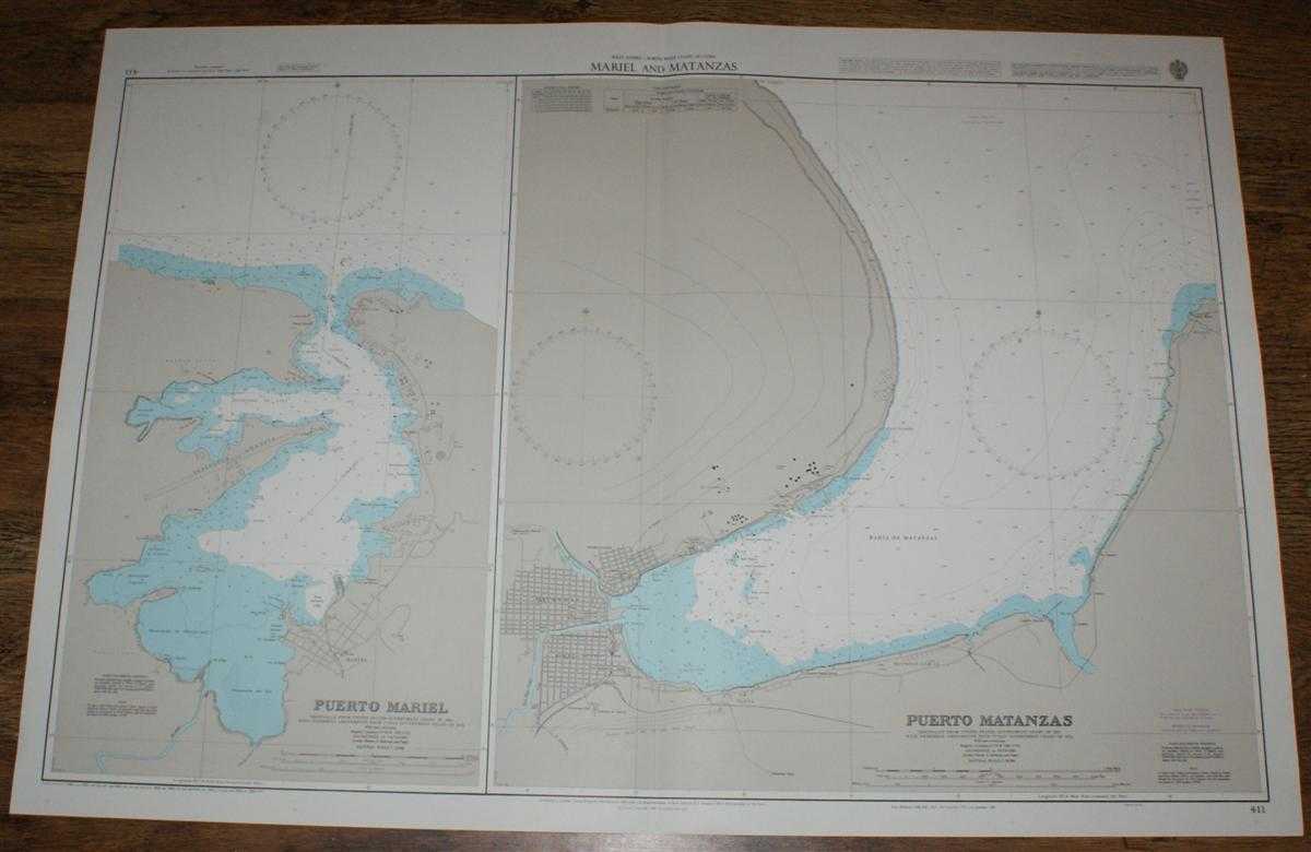
Description: Map Admiralty, 2001. Revised Edition, Softcover. Very Good Condition/No Dust Jacket. Crisp and clean colour chart with single vertical fold. Nautical Chart No. 411 West Indies - North West Coast of Cuba, Mariel and Matanzas. Copyright 1988 with small corrections to 2001. Sheet contains two charts: Puerto Mariel at scale 1:12,500 and Puerto Matanzas at scale 1:20,000. Area Covered: Mariel, Peninsula Angosta, Punta Barlovento, Ensenada de Laza, Ensenada de Blanquizal, Rio Bongo, Ensenada la Tabaquera, Matanzas, Pueblo Nuevo, Versalles, Playa, Reynold Garcia, Bahia de Matanzas, Rio Canimar, Castillo Morillo, Punta Maya. Size: 72x104cm. Item Type: Map. Quantity Available: 1. Shipped Weight: under 1 kg. Pictures of this item not already displayed here available upon request. Inventory No: 45517094001. ISBN: 1859831060
Keywords: BZDB4 Maps; naval, naval history, maritime, ships, boats; South & Central America & the West Indies. Admiralty Nautical Chart No. 411 West Indies - North West Coast of Cuba, Mariel and Matanzas naval, naval history, maritime, ships, boats South & Centra
See more books from our catalog: Maps
Title: Nautical Chart No. 411 West Indies - North West Coast of Cuba, Mariel and Matanzas
Description: Map Admiralty, 2001. Revised Edition, Softcover. Very Good Condition/No Dust Jacket. Crisp and clean colour chart with single vertical fold. Nautical Chart No. 411 West Indies - North West Coast of Cuba, Mariel and Matanzas. Copyright 1988 with small corrections to 2001. Sheet contains two charts: Puerto Mariel at scale 1:12,500 and Puerto Matanzas at scale 1:20,000. Area Covered: Mariel, Peninsula Angosta, Punta Barlovento, Ensenada de Laza, Ensenada de Blanquizal, Rio Bongo, Ensenada la Tabaquera, Matanzas, Pueblo Nuevo, Versalles, Playa, Reynold Garcia, Bahia de Matanzas, Rio Canimar, Castillo Morillo, Punta Maya. Size: 72x104cm. Item Type: Map. Quantity Available: 1. Shipped Weight: under 1 kg. Pictures of this item not already displayed here available upon request. Inventory No: 45517094001. ISBN: 1859831060
Keywords: BZDB4 Maps; naval, naval history, maritime, ships, boats; South & Central America & the West Indies. Admiralty Nautical Chart No. 411 West Indies - North West Coast of Cuba, Mariel and Matanzas naval, naval history, maritime, ships, boats South & Centra
Price: GBP 26.00 = appr. US$ 37.13 Seller: Bailgate Books Ltd
- Book number: 45517094001
- Book number: 45517094001
See more books from our catalog: Maps