Author: Admiralty
Title: Nautical Chart No. 909 Pacific Ocean - Islands and Anchorages in the Caroline Islands
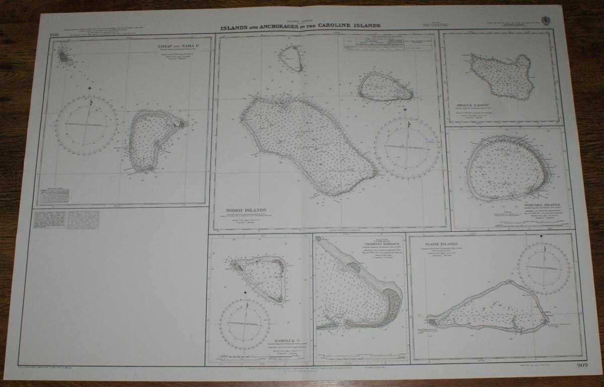
Description: Map Admiralty, 2005. Revised Edition, Softcover. Very Good Condition/No Dust Jacket. Crisp and clean black and white chart with single vertical fold. Some tea stains on reverse which have not bled through to front of sheet. Nautical Chart No. 909 Pacific Ocean - Islands and Anchorages in the Caroline Islands. Copyright 1948 with small corrections to 2005. Sheet contains seven separate charts: Losap and Nama Islands at scale 1:75,000 Nomoi Islands (Satawan, Etal and Lukunor Islands) at scale 1:125,000 Namoluk Island at scale 1:50,000 Chamisso Harbour at scale 1:30,000 Oroluk Lagoon at scale 1:250,000 Nukuoro Islands at scale 1:50,000 Ngatik Islands at scale 1:100,000 Item Type: Map. Quantity Available: 1. Shipped Weight: under 1 kg. Pictures of this item not already displayed here available upon request. Inventory No: 45517084061. ISBN: 1859831060
Keywords: BZDB4 Maps; naval, naval history, maritime, ships, boats; Australasia and the Pacific. Admiralty Nautical Chart No. 909 Pacific Ocean - Islands and Anchorages in the Caroline Islands naval, naval history, maritime, ships, boats Australasia and the Pacif
See more books from our catalog: Maps
Title: Nautical Chart No. 909 Pacific Ocean - Islands and Anchorages in the Caroline Islands
Description: Map Admiralty, 2005. Revised Edition, Softcover. Very Good Condition/No Dust Jacket. Crisp and clean black and white chart with single vertical fold. Some tea stains on reverse which have not bled through to front of sheet. Nautical Chart No. 909 Pacific Ocean - Islands and Anchorages in the Caroline Islands. Copyright 1948 with small corrections to 2005. Sheet contains seven separate charts: Losap and Nama Islands at scale 1:75,000 Nomoi Islands (Satawan, Etal and Lukunor Islands) at scale 1:125,000 Namoluk Island at scale 1:50,000 Chamisso Harbour at scale 1:30,000 Oroluk Lagoon at scale 1:250,000 Nukuoro Islands at scale 1:50,000 Ngatik Islands at scale 1:100,000 Item Type: Map. Quantity Available: 1. Shipped Weight: under 1 kg. Pictures of this item not already displayed here available upon request. Inventory No: 45517084061. ISBN: 1859831060
Keywords: BZDB4 Maps; naval, naval history, maritime, ships, boats; Australasia and the Pacific. Admiralty Nautical Chart No. 909 Pacific Ocean - Islands and Anchorages in the Caroline Islands naval, naval history, maritime, ships, boats Australasia and the Pacif
Price: GBP 26.00 = appr. US$ 37.13 Seller: Bailgate Books Ltd
- Book number: 45517084061
- Book number: 45517084061
See more books from our catalog: Maps