Author: Admiralty
Title: Nautical Chart No. AUS 384 Papua New Guinea - North East Coast, Cape Vogel to Cape Nelson including Trobriand Islands
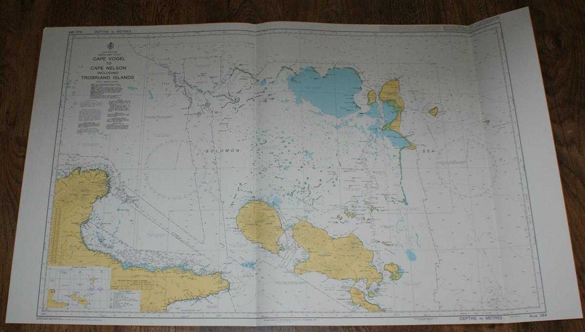
Description: Admiralty, 2005. Revised Edition, Softcover. Very Good Condition/No Dust Jacket. Crisp and clean colour chart with two vertical folds. Nautical Chart No. AUS 384 Papua New Guinea - North East Coast, Cape Vogel to Cape Nelson including Trobriand Islands. Copyright 1992 with small corrections to 2005. Scale 1:300,000. Area Covered: Papua New Guinea (part), Cape Nelson, Cape Vogel, Goodenough Island, Fergusson Island, D'Entrecasteaux Islands, Lusancay Islands and Reefs, Trobriand Islands, Kiriwina Island, Kaileuna Island, Marshall Bennett Islands (part). Solomon Sea, Collingwood Bay, Ward Hunt Strait, Moresby Strait, Star Reefs Passage, Taiagila Bay. Size: 72x119cm. Single sheet map/chart which is suitable for framing and will be shipped rolled and in a cardboard tube. Quantity Available: 1. Shipped Weight: under 1 kg. Pictures of this item not already displayed here available upon request. Inventory No: 45517084040. ISBN: 1844940721
Keywords: BZDB4 Maps; Australasia and the Pacific; naval, naval history, maritime, ships, boats. Admiralty Nautical Chart No. AUS 384 Papua New Guinea - North East Coast, Cape Vogel to Cape Nelson including Trobriand Islands Australasia and the Pacific naval, nav
See more books from our catalog: Maps
Title: Nautical Chart No. AUS 384 Papua New Guinea - North East Coast, Cape Vogel to Cape Nelson including Trobriand Islands
Description: Admiralty, 2005. Revised Edition, Softcover. Very Good Condition/No Dust Jacket. Crisp and clean colour chart with two vertical folds. Nautical Chart No. AUS 384 Papua New Guinea - North East Coast, Cape Vogel to Cape Nelson including Trobriand Islands. Copyright 1992 with small corrections to 2005. Scale 1:300,000. Area Covered: Papua New Guinea (part), Cape Nelson, Cape Vogel, Goodenough Island, Fergusson Island, D'Entrecasteaux Islands, Lusancay Islands and Reefs, Trobriand Islands, Kiriwina Island, Kaileuna Island, Marshall Bennett Islands (part). Solomon Sea, Collingwood Bay, Ward Hunt Strait, Moresby Strait, Star Reefs Passage, Taiagila Bay. Size: 72x119cm. Single sheet map/chart which is suitable for framing and will be shipped rolled and in a cardboard tube. Quantity Available: 1. Shipped Weight: under 1 kg. Pictures of this item not already displayed here available upon request. Inventory No: 45517084040. ISBN: 1844940721
Keywords: BZDB4 Maps; Australasia and the Pacific; naval, naval history, maritime, ships, boats. Admiralty Nautical Chart No. AUS 384 Papua New Guinea - North East Coast, Cape Vogel to Cape Nelson including Trobriand Islands Australasia and the Pacific naval, nav
Price: GBP 26.00 = appr. US$ 37.13 Seller: Bailgate Books Ltd
- Book number: 45517084040
- Book number: 45517084040
See more books from our catalog: Maps