Author: Admiralty
Title: Nautical Chart No. 977 Pacific Ocean - Islands and Anchorages in the Caroline Islands
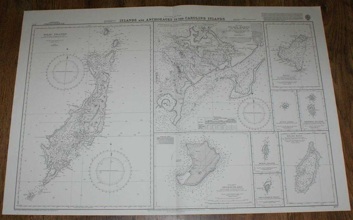
Description: Admiralty, 2000. Revised Edition, Softcover. Very Good Condition/No Dust Jacket. Crisp and clean colour chart with single vertical fold. Nautical Chart No. 977 Pacific Ocean - Islands and Anchorages in the Caroline Islands. Copyright 1977 with small corrections to 2000. Sheet contains nine separate charts: Palau Islands at scale 1:250,000 Malakal Harbour and Koror Road at scale 1:49,800 Ngulu or Lamoliaur Ulu Islands at scale 1:249,500 Pulo Anna at scale 1:72,560 Sonsorol Islands at scale 1:72,560 Angaur Island at scale 1:30,000 Merir Island at scale 1:72,560 Tobi or Kodgubi Island at scale 1:72,560 Helen Reef at scale 1:45,000 Size: 72x107cm. Single sheet map/chart which is suitable for framing and will be shipped rolled and in a cardboard tube. Quantity Available: 1. Shipped Weight: under 1 kg. Pictures of this item not already displayed here available upon request. Inventory No: 45517084036. ISBN: 1844940721
Keywords: BZDB4 Maps; Australasia and the Pacific; naval, naval history, maritime, ships, boats. Admiralty Nautical Chart No. 977 Pacific Ocean - Islands and Anchorages in the Caroline Islands Australasia and the Pacific naval, naval history, maritime, ships, boa
See more books from our catalog: Maps
Title: Nautical Chart No. 977 Pacific Ocean - Islands and Anchorages in the Caroline Islands
Description: Admiralty, 2000. Revised Edition, Softcover. Very Good Condition/No Dust Jacket. Crisp and clean colour chart with single vertical fold. Nautical Chart No. 977 Pacific Ocean - Islands and Anchorages in the Caroline Islands. Copyright 1977 with small corrections to 2000. Sheet contains nine separate charts: Palau Islands at scale 1:250,000 Malakal Harbour and Koror Road at scale 1:49,800 Ngulu or Lamoliaur Ulu Islands at scale 1:249,500 Pulo Anna at scale 1:72,560 Sonsorol Islands at scale 1:72,560 Angaur Island at scale 1:30,000 Merir Island at scale 1:72,560 Tobi or Kodgubi Island at scale 1:72,560 Helen Reef at scale 1:45,000 Size: 72x107cm. Single sheet map/chart which is suitable for framing and will be shipped rolled and in a cardboard tube. Quantity Available: 1. Shipped Weight: under 1 kg. Pictures of this item not already displayed here available upon request. Inventory No: 45517084036. ISBN: 1844940721
Keywords: BZDB4 Maps; Australasia and the Pacific; naval, naval history, maritime, ships, boats. Admiralty Nautical Chart No. 977 Pacific Ocean - Islands and Anchorages in the Caroline Islands Australasia and the Pacific naval, naval history, maritime, ships, boa
Price: GBP 26.00 = appr. US$ 37.13 Seller: Bailgate Books Ltd
- Book number: 45517084036
- Book number: 45517084036
See more books from our catalog: Maps