Author: Admiralty
Title: Nautical Chart No. 1485 North Pacific Ocean - Caroline Islands, Yap Islands
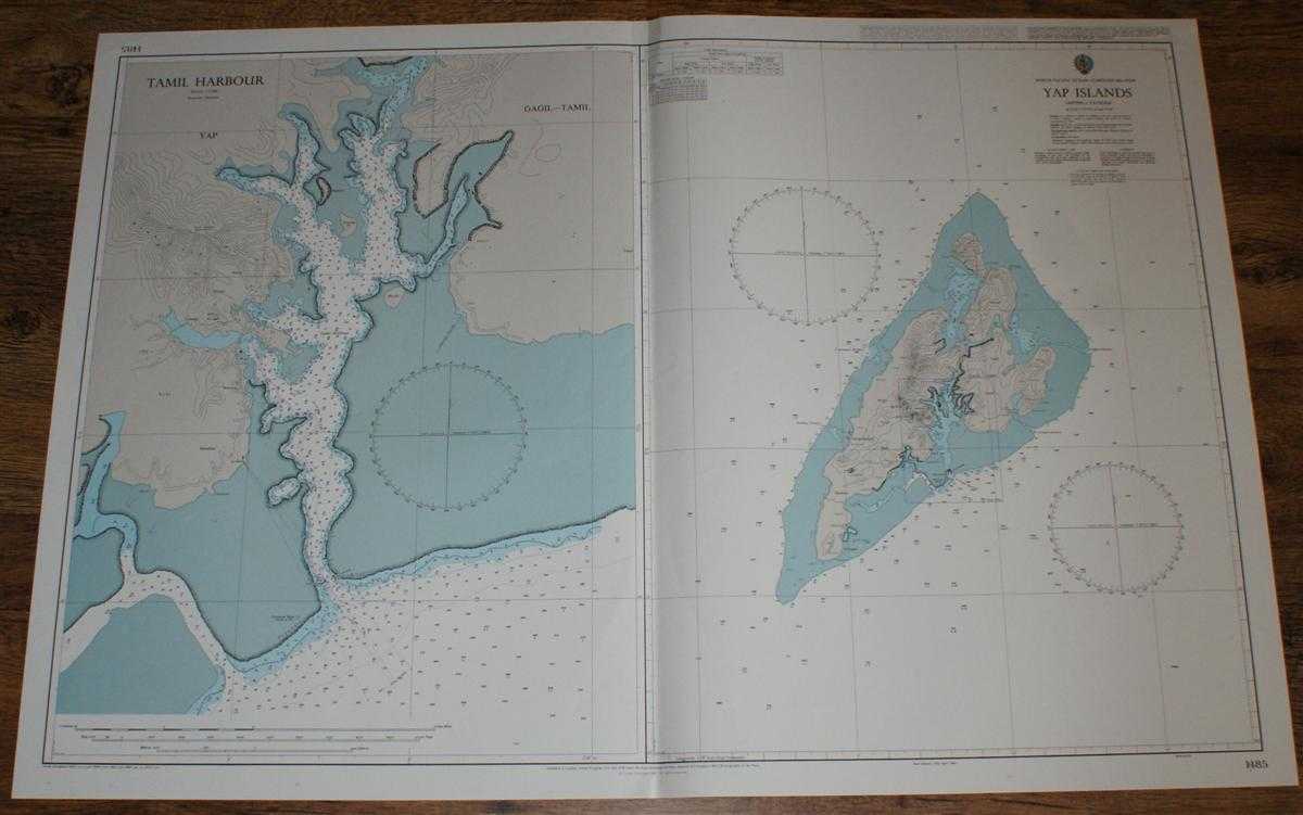
Description: Admiralty, 2003. Revised Edition, Softcover. Very Good Condition/No Dust Jacket. Crisp and clean colour chart with single vertical fold. Nautical Chart No. 1485 North Pacific Ocean - Caroline Islands, Yap Islands. Copyright 1987 with small corrections to 2003. Sheet is divided into two charts: Yap Isalnds at scale 1:72,570 and Tamil Harbour at scale 1:12,500. Area Covered: Yap, Gagil-Tamil, Maap, Rumung, Weloy, Ruul, Dalipeebinaew, Kanifaay, Gilmaan, Tamil Harbour, Bura Hills, Biy, Tarang, Paakeal, Keeng, Nimaar, Colonia, Worwoq, Baleabaat. Size: 72x107cm. Single sheet map/chart which is suitable for framing and will be shipped rolled and in a cardboard tube. Quantity Available: 1. Shipped Weight: under 1 kg. Pictures of this item not already displayed here available upon request. Inventory No: 45517084018. ISBN: 1844940721
Keywords: BZDB4 Maps; Australasia and the Pacific; naval, naval history, maritime, ships, boats. Admiralty Nautical Chart No. 1485 North Pacific Ocean - Caroline Islands, Yap Islands Australasia and the Pacific naval, naval history, maritime, ships, boats
See more books from our catalog: Maps
Title: Nautical Chart No. 1485 North Pacific Ocean - Caroline Islands, Yap Islands
Description: Admiralty, 2003. Revised Edition, Softcover. Very Good Condition/No Dust Jacket. Crisp and clean colour chart with single vertical fold. Nautical Chart No. 1485 North Pacific Ocean - Caroline Islands, Yap Islands. Copyright 1987 with small corrections to 2003. Sheet is divided into two charts: Yap Isalnds at scale 1:72,570 and Tamil Harbour at scale 1:12,500. Area Covered: Yap, Gagil-Tamil, Maap, Rumung, Weloy, Ruul, Dalipeebinaew, Kanifaay, Gilmaan, Tamil Harbour, Bura Hills, Biy, Tarang, Paakeal, Keeng, Nimaar, Colonia, Worwoq, Baleabaat. Size: 72x107cm. Single sheet map/chart which is suitable for framing and will be shipped rolled and in a cardboard tube. Quantity Available: 1. Shipped Weight: under 1 kg. Pictures of this item not already displayed here available upon request. Inventory No: 45517084018. ISBN: 1844940721
Keywords: BZDB4 Maps; Australasia and the Pacific; naval, naval history, maritime, ships, boats. Admiralty Nautical Chart No. 1485 North Pacific Ocean - Caroline Islands, Yap Islands Australasia and the Pacific naval, naval history, maritime, ships, boats
Price: GBP 26.00 = appr. US$ 37.13 Seller: Bailgate Books Ltd
- Book number: 45517084018
- Book number: 45517084018
See more books from our catalog: Maps