Author: Admiralty
Title: Nautical Chart No. 1735 South Pacific Ocean, Solomon Islands, Plans in the New Georgia Group
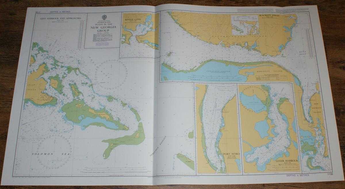
Description: Admiralty, 1999. Revised Edition, Softcover. Very Good Condition/No Dust Jacket. Crisp and clean colour chart with two vertical folds. Nautical Chart No. 1735 South Pacific Ocean, Solomon Islands, Plans in the New Georgia Group. Copyright 1980 with small corrections to 1999. Sheet contains five separate charts: Gizo Harbour and Approaches at scale 1:25,000 Blackett Strait at scale 1:50,000 Port Noro at scale 1:20,000 Lever Harbour at scale 1:7,500 Ringgi Cove at scale 1:15,000 Area Covered: Ghizo Island, Mbambanga Island, Logha Island, Vella Gulf, Solomon Sea, Ferguson Passage, Hathorn Sound, Noro, Gizo, Ringge, Nusatuva Island, Kolombangara Island, Vonavona Lagoon, Kohinggo Island, Kula Gulf, New Georgia Island, Mbaeni Harbour, Daymark. Size: 72x119cm. Single sheet map/chart which is suitable for framing and will be shipped rolled and in a cardboard tube. Quantity Available: 1. Shipped Weight: under 1 kg. Pictures of this item not already displayed here available upon request. Inventory No: 45517084014. ISBN: 1844940721
Keywords: BZDB4 Maps; Australasia and the Pacific; naval, naval history, maritime, ships, boats. Admiralty Nautical Chart No. 1735 South Pacific Ocean, Solomon Islands, Plans in the New Georgia Group Australasia and the Pacific naval, naval history, maritime, shi
See more books from our catalog: Maps
Title: Nautical Chart No. 1735 South Pacific Ocean, Solomon Islands, Plans in the New Georgia Group
Description: Admiralty, 1999. Revised Edition, Softcover. Very Good Condition/No Dust Jacket. Crisp and clean colour chart with two vertical folds. Nautical Chart No. 1735 South Pacific Ocean, Solomon Islands, Plans in the New Georgia Group. Copyright 1980 with small corrections to 1999. Sheet contains five separate charts: Gizo Harbour and Approaches at scale 1:25,000 Blackett Strait at scale 1:50,000 Port Noro at scale 1:20,000 Lever Harbour at scale 1:7,500 Ringgi Cove at scale 1:15,000 Area Covered: Ghizo Island, Mbambanga Island, Logha Island, Vella Gulf, Solomon Sea, Ferguson Passage, Hathorn Sound, Noro, Gizo, Ringge, Nusatuva Island, Kolombangara Island, Vonavona Lagoon, Kohinggo Island, Kula Gulf, New Georgia Island, Mbaeni Harbour, Daymark. Size: 72x119cm. Single sheet map/chart which is suitable for framing and will be shipped rolled and in a cardboard tube. Quantity Available: 1. Shipped Weight: under 1 kg. Pictures of this item not already displayed here available upon request. Inventory No: 45517084014. ISBN: 1844940721
Keywords: BZDB4 Maps; Australasia and the Pacific; naval, naval history, maritime, ships, boats. Admiralty Nautical Chart No. 1735 South Pacific Ocean, Solomon Islands, Plans in the New Georgia Group Australasia and the Pacific naval, naval history, maritime, shi
Price: GBP 26.00 = appr. US$ 37.13 Seller: Bailgate Books Ltd
- Book number: 45517084014
- Book number: 45517084014
See more books from our catalog: Maps