Author: Admiralty
Title: Nautical Chart No. 1750 South Pacific Ocean - Solomon Islands, Anchorages in Guadalcanal Island
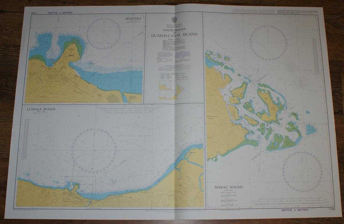
Description: Admiralty, 2004. Revised Edition, Softcover. Very Good Condition/No Dust Jacket. Crisp and clean colour chart with single vertical fold. Very slight wear to left and right hand edges. Nautical Chart No. 1750 South Pacific Ocean - Solomon Islands, Anchorages in Guadalcanal Island. Copyright 1995 with small corrections to 2004. Sheet contains three charts: Marau Sound at scale 1:50,000 Lungga Roads at scale 1:20,000 Honiara at scale 1:5,000 Area Covered: Honiara, Point Cruz, Vavaya Ridge, Lungga Roads, Ranadi Beach, Lungga River, Guadalcanal Island (part), Maruiapa or Beagle Island, Wahere Island, Marapa Island, Wilson Islands, Tawa'ihi Island, Ma'au Reef, Aaritenamo Reef, Ruotopa Reef, Ta'aru Reef. Size: 72x107cm. Single sheet map/chart which is suitable for framing and will be shipped rolled and in a cardboard tube. Quantity Available: 1. Shipped Weight: under 1 kg. Pictures of this item not already displayed here available upon request. Inventory No: 45517084010. ISBN: 1844940721
Keywords: BZDB4 Maps; Australasia and the Pacific; naval, naval history, maritime, ships, boats. Admiralty Nautical Chart No. 1750 South Pacific Ocean - Solomon Islands, Anchorages in Guadalcanal Island Australasia and the Pacific naval, naval history, maritime,
See more books from our catalog: Maps
Title: Nautical Chart No. 1750 South Pacific Ocean - Solomon Islands, Anchorages in Guadalcanal Island
Description: Admiralty, 2004. Revised Edition, Softcover. Very Good Condition/No Dust Jacket. Crisp and clean colour chart with single vertical fold. Very slight wear to left and right hand edges. Nautical Chart No. 1750 South Pacific Ocean - Solomon Islands, Anchorages in Guadalcanal Island. Copyright 1995 with small corrections to 2004. Sheet contains three charts: Marau Sound at scale 1:50,000 Lungga Roads at scale 1:20,000 Honiara at scale 1:5,000 Area Covered: Honiara, Point Cruz, Vavaya Ridge, Lungga Roads, Ranadi Beach, Lungga River, Guadalcanal Island (part), Maruiapa or Beagle Island, Wahere Island, Marapa Island, Wilson Islands, Tawa'ihi Island, Ma'au Reef, Aaritenamo Reef, Ruotopa Reef, Ta'aru Reef. Size: 72x107cm. Single sheet map/chart which is suitable for framing and will be shipped rolled and in a cardboard tube. Quantity Available: 1. Shipped Weight: under 1 kg. Pictures of this item not already displayed here available upon request. Inventory No: 45517084010. ISBN: 1844940721
Keywords: BZDB4 Maps; Australasia and the Pacific; naval, naval history, maritime, ships, boats. Admiralty Nautical Chart No. 1750 South Pacific Ocean - Solomon Islands, Anchorages in Guadalcanal Island Australasia and the Pacific naval, naval history, maritime,
Price: GBP 26.00 = appr. US$ 37.13 Seller: Bailgate Books Ltd
- Book number: 45517084010
- Book number: 45517084010
See more books from our catalog: Maps