Author: Admiralty
Title: Nautical Chart No. 1766 South Pacific Ocean - Harbours in the Solomon Islands
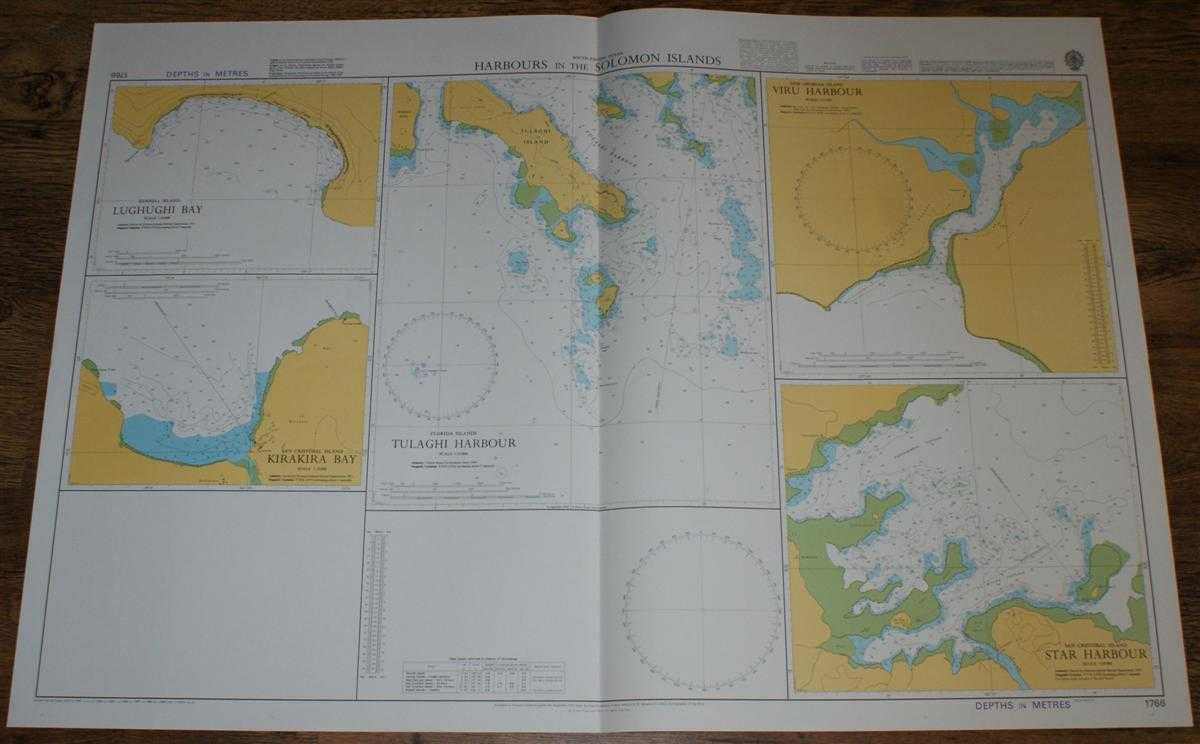
Description: Admiralty, 2004. Revised Edition, Softcover. Very Good Condition/No Dust Jacket. Crisp and clean colour chart with single vertical fold. Nautical Chart No. 1766 South Pacific Ocean - Harbours in the Solomon Islands. Copyright 1978 with small corrections to 2004. Sheet contains five separate charts: Lughughi Bay (Rennell Island) at scale 1:30,000 Kirakira Bay (San Cristobal Island) at scale 1:10,000 Tulaghi Harbour (Florida Islands) at scale 1:15,000 Viru Harbour (New Georgia Island) at scale 1:12,500 Star Harbour (San Cristobal Island) at scale 1:20,000 Size: 72x107cm. Single sheet map/chart which is suitable for framing and will be shipped rolled and in a cardboard tube. Quantity Available: 1. Shipped Weight: under 1 kg. Pictures of this item not already displayed here available upon request. Inventory No: 45517084009. ISBN: 1844940721
Keywords: BZDB4 Maps; Australasia and the Pacific; naval, naval history, maritime, ships, boats. Admiralty Nautical Chart No. 1766 South Pacific Ocean - Harbours in the Solomon Islands Australasia and the Pacific naval, naval history, maritime, ships, boats
See more books from our catalog: Maps
Title: Nautical Chart No. 1766 South Pacific Ocean - Harbours in the Solomon Islands
Description: Admiralty, 2004. Revised Edition, Softcover. Very Good Condition/No Dust Jacket. Crisp and clean colour chart with single vertical fold. Nautical Chart No. 1766 South Pacific Ocean - Harbours in the Solomon Islands. Copyright 1978 with small corrections to 2004. Sheet contains five separate charts: Lughughi Bay (Rennell Island) at scale 1:30,000 Kirakira Bay (San Cristobal Island) at scale 1:10,000 Tulaghi Harbour (Florida Islands) at scale 1:15,000 Viru Harbour (New Georgia Island) at scale 1:12,500 Star Harbour (San Cristobal Island) at scale 1:20,000 Size: 72x107cm. Single sheet map/chart which is suitable for framing and will be shipped rolled and in a cardboard tube. Quantity Available: 1. Shipped Weight: under 1 kg. Pictures of this item not already displayed here available upon request. Inventory No: 45517084009. ISBN: 1844940721
Keywords: BZDB4 Maps; Australasia and the Pacific; naval, naval history, maritime, ships, boats. Admiralty Nautical Chart No. 1766 South Pacific Ocean - Harbours in the Solomon Islands Australasia and the Pacific naval, naval history, maritime, ships, boats
Price: GBP 26.00 = appr. US$ 37.13 Seller: Bailgate Books Ltd
- Book number: 45517084009
- Book number: 45517084009
See more books from our catalog: Maps