Author: Admiralty
Title: Nautical Chart No. 2961 Barents Sea - Russia, Pechorskaya Guba
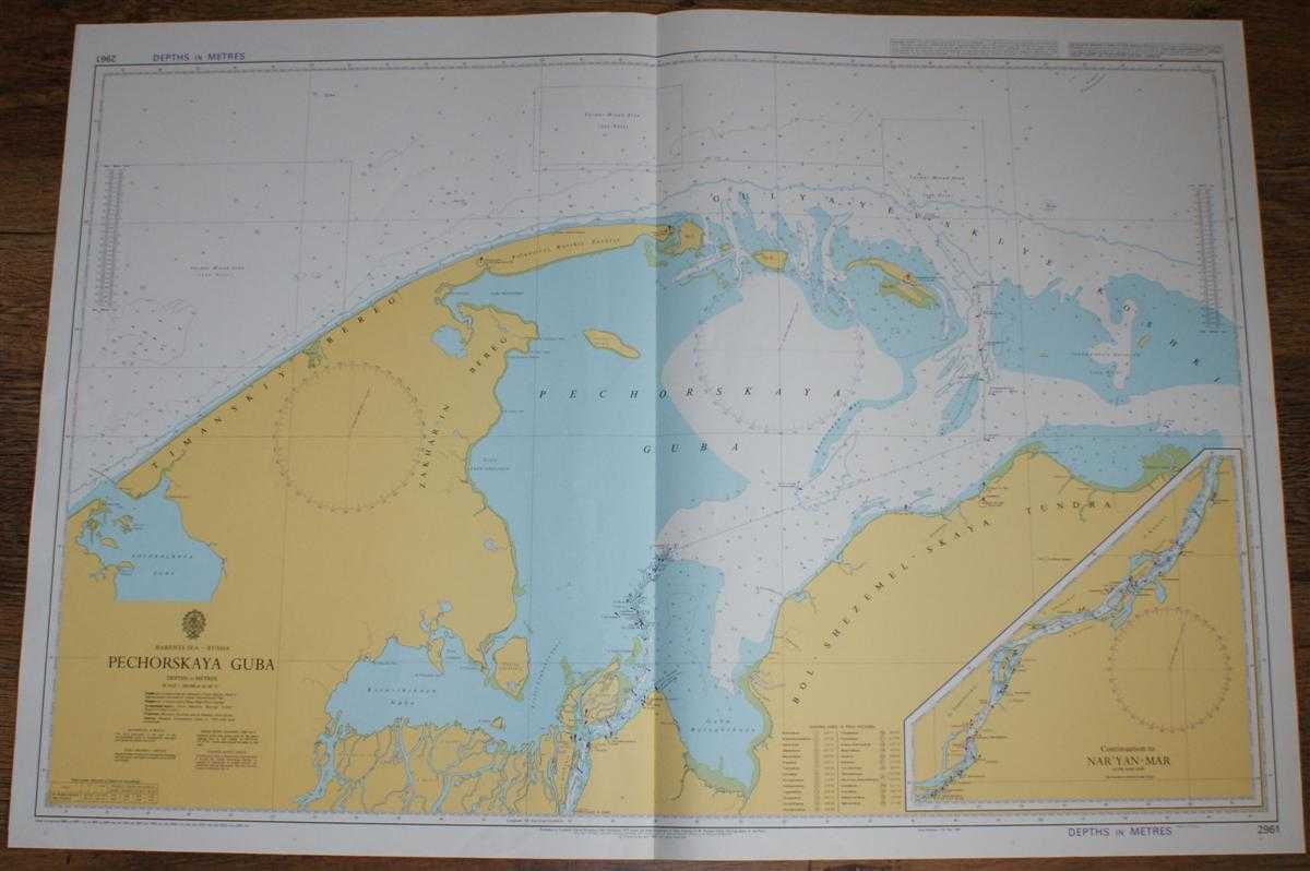
Description: Admiralty, 2005. Revised Edition, Softcover. Very Good Condition/No Dust Jacket. Crisp and clean colour chart with single vertical fold. Nautical Chart No. 2961 Barents Sea - Russia, Pechorskaya Guba. Copyright 1985 with small corrections to 2005. Scale 1:200,000. Sheet contains inset at same scale of 'Continuation to Nar'yan-Mar'. Area Covered: Russia (part), Timanskiy Bereg, Zakhar'in Bereg, Poluostrov Russkiy Zavorot, Bol'shezemel'skaya Tundra. Barents Sea (part), Pechorskaya Guba, Kolokolkova Guba, Korovinskaya Guba, Guba Bolvanskaya, Gulyayevskiye Koshki, Reka Pechora. Size: 72x104. Single sheet map/chart which is suitable for framing and will be shipped rolled and in a cardboard tube.. Quantity Available: 1. Shipped Weight: under 1 kg. Pictures of this item not already displayed here available upon request. Inventory No: 45517074040. ISBN: 0304355410
Keywords: BZDB4 Russia & Eastern Europe; Arctic & Antarctic. Admiralty Nautical Chart No. 2961 Barents Sea - Russia, Pechorskaya Guba Arctic & Antarctic
See more books from our catalog: Russia & Eastern Europe
Title: Nautical Chart No. 2961 Barents Sea - Russia, Pechorskaya Guba
Description: Admiralty, 2005. Revised Edition, Softcover. Very Good Condition/No Dust Jacket. Crisp and clean colour chart with single vertical fold. Nautical Chart No. 2961 Barents Sea - Russia, Pechorskaya Guba. Copyright 1985 with small corrections to 2005. Scale 1:200,000. Sheet contains inset at same scale of 'Continuation to Nar'yan-Mar'. Area Covered: Russia (part), Timanskiy Bereg, Zakhar'in Bereg, Poluostrov Russkiy Zavorot, Bol'shezemel'skaya Tundra. Barents Sea (part), Pechorskaya Guba, Kolokolkova Guba, Korovinskaya Guba, Guba Bolvanskaya, Gulyayevskiye Koshki, Reka Pechora. Size: 72x104. Single sheet map/chart which is suitable for framing and will be shipped rolled and in a cardboard tube.. Quantity Available: 1. Shipped Weight: under 1 kg. Pictures of this item not already displayed here available upon request. Inventory No: 45517074040. ISBN: 0304355410
Keywords: BZDB4 Russia & Eastern Europe; Arctic & Antarctic. Admiralty Nautical Chart No. 2961 Barents Sea - Russia, Pechorskaya Guba Arctic & Antarctic
Price: GBP 26.00 = appr. US$ 37.13 Seller: Bailgate Books Ltd
- Book number: 45517074040
- Book number: 45517074040
See more books from our catalog: Russia & Eastern Europe