Author: Admiralty
Title: Nautical Chart No. 3249 Indonesia - Irian Jaya - North Coast, Teluk Irian
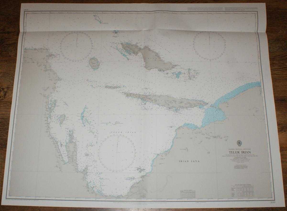
Description: Admiralty, 1998. Revised Edition, Softcover. Very Good Condition/No Dust Jacket. Crisp and clean colour chart with vertical centre fold and horizontal fold near upper edge. Top edge is very slightly creased. Nautical Chart No. 3249 Indonesia - Irian Jaya - North Coast, Teluk Irian. Copyright 1988 with small corrections to 1998. Scale 1:500,000. Area Covered: Irian Jaya (part), West Papua (part), Papua (part), Supiori, Biak, Mefoor, Miosnum, Sorenarwa, Warupen, Mios Auri, Mios Waar, Rumberpon. Teluk Irian, Selat Sorenarwa, Pulau-Pulau Biak, Selat Aruri, Selat Kurudu Size: 84x104cm. Quantity Available: 1. Shipped Weight: under 1 kg. Pictures of this item not already displayed here available upon request. Inventory No: 45517074003. ISBN: 0710626231
Keywords: BZDB4 Maps; Indian sub-continent & South East Asia; Australasia and the Pacific; naval, naval history, maritime, ships, boats. Admiralty Nautical Chart No. 3249 Indonesia - Irian Jaya - North Coast, Teluk Irian Indian sub-continent & South East Asia Austr
See more books from our catalog: Maps
Title: Nautical Chart No. 3249 Indonesia - Irian Jaya - North Coast, Teluk Irian
Description: Admiralty, 1998. Revised Edition, Softcover. Very Good Condition/No Dust Jacket. Crisp and clean colour chart with vertical centre fold and horizontal fold near upper edge. Top edge is very slightly creased. Nautical Chart No. 3249 Indonesia - Irian Jaya - North Coast, Teluk Irian. Copyright 1988 with small corrections to 1998. Scale 1:500,000. Area Covered: Irian Jaya (part), West Papua (part), Papua (part), Supiori, Biak, Mefoor, Miosnum, Sorenarwa, Warupen, Mios Auri, Mios Waar, Rumberpon. Teluk Irian, Selat Sorenarwa, Pulau-Pulau Biak, Selat Aruri, Selat Kurudu Size: 84x104cm. Quantity Available: 1. Shipped Weight: under 1 kg. Pictures of this item not already displayed here available upon request. Inventory No: 45517074003. ISBN: 0710626231
Keywords: BZDB4 Maps; Indian sub-continent & South East Asia; Australasia and the Pacific; naval, naval history, maritime, ships, boats. Admiralty Nautical Chart No. 3249 Indonesia - Irian Jaya - North Coast, Teluk Irian Indian sub-continent & South East Asia Austr
Price: GBP 28.00 = appr. US$ 39.98 Seller: Bailgate Books Ltd
- Book number: 45517074003
- Book number: 45517074003
See more books from our catalog: Maps