Author: Admiralty
Title: Nautical Chart No. 1856 North Atlantic Ocean - Plans in Islas Canarias
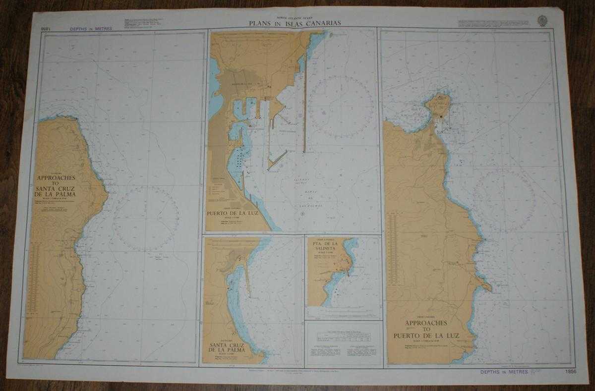
Description: Map Admiralty, 1986. Revised Edition, Softcover. Good Condition/No Dust Jacket. Colour chart is very lightly marked. Single vertical fold with some creasing at the top of the fold. Edges and top corners are slightly worn. Nautical Chart No. 1856 North Atlantic Ocean - Plans in Islas Canarias. Copyright 1985 with small corrections to 1986. Sheet consists of five separate charts: La Palma - Approaches to Santa Cruz de la Palma at scale 1:75,000 Gran Canaria - Puerto de la Luz at scale 1:15,000 La Palma - Santa Cruz de la Palma at scale 1:12,000 Gran Canaria - Pta. de la Salineta at scale 1:15,000 Gran Canaria - Approaches to Puerto de la Luz at scale 1:75,000 Size: 71x104cm. Item Type: Map. No dust jacket, as published. Single sheet map/chart which is suitable for framing and will be shipped rolled and in a cardboard tube.. Quantity Available: 1. Shipped Weight: under 1 kg. Pictures of this item not already displayed here available upon request. Inventory No: 45517021420. ISBN: 0002116448
Keywords: BZDB4 Maps; Spain and Portugal, Spanish & Portuguese Language; naval, naval history, maritime, ships, boats. Admiralty Nautical Chart No. 1856 North Atlantic Ocean - Plans in Islas Canarias Spain and Portugal, Spanish & Portuguese Language naval, naval
See more books from our catalog: Maps
Title: Nautical Chart No. 1856 North Atlantic Ocean - Plans in Islas Canarias
Description: Map Admiralty, 1986. Revised Edition, Softcover. Good Condition/No Dust Jacket. Colour chart is very lightly marked. Single vertical fold with some creasing at the top of the fold. Edges and top corners are slightly worn. Nautical Chart No. 1856 North Atlantic Ocean - Plans in Islas Canarias. Copyright 1985 with small corrections to 1986. Sheet consists of five separate charts: La Palma - Approaches to Santa Cruz de la Palma at scale 1:75,000 Gran Canaria - Puerto de la Luz at scale 1:15,000 La Palma - Santa Cruz de la Palma at scale 1:12,000 Gran Canaria - Pta. de la Salineta at scale 1:15,000 Gran Canaria - Approaches to Puerto de la Luz at scale 1:75,000 Size: 71x104cm. Item Type: Map. No dust jacket, as published. Single sheet map/chart which is suitable for framing and will be shipped rolled and in a cardboard tube.. Quantity Available: 1. Shipped Weight: under 1 kg. Pictures of this item not already displayed here available upon request. Inventory No: 45517021420. ISBN: 0002116448
Keywords: BZDB4 Maps; Spain and Portugal, Spanish & Portuguese Language; naval, naval history, maritime, ships, boats. Admiralty Nautical Chart No. 1856 North Atlantic Ocean - Plans in Islas Canarias Spain and Portugal, Spanish & Portuguese Language naval, naval
Price: GBP 24.00 = appr. US$ 34.27 Seller: Bailgate Books Ltd
- Book number: 45517021420
- Book number: 45517021420
See more books from our catalog: Maps