Author: Admiralty
Title: Nautical Chart No. 886 Islas Canarias - Estrecho de la Bocayna and Approaches to Arrecife
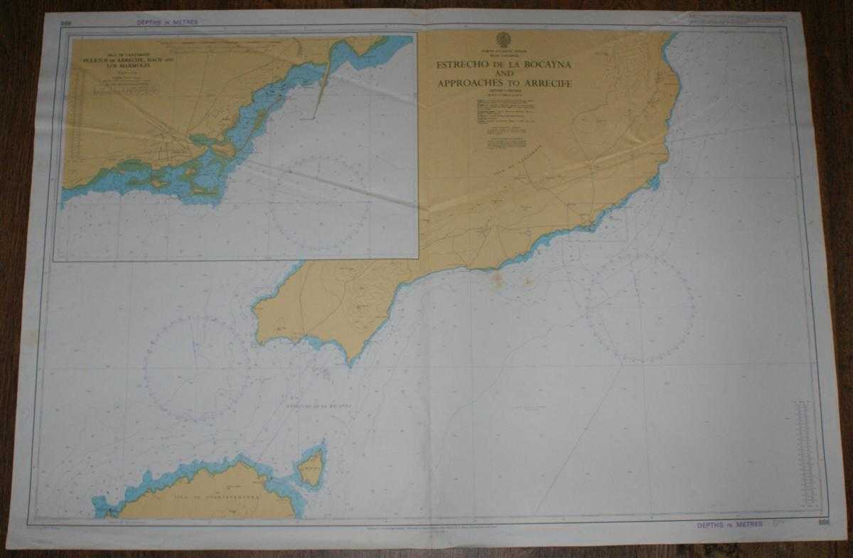
Description: Map Admiralty, 1985. Revised Edition, Softcover. Fair Condition/No Dust Jacket. Colour chart with vertical centre fold. Sheet is slightly marked and has some light pencil annotation. Edges are a little worn. Sheet is markedly creased in the upper half and along the centre fold Nautical Chart No. 886 Islas Canarias - Estrecho de la Bocayna and Approaches to Arrecife. Copyright 1985 with small corrections to 1986. Scale 1:75,000 Sheet contains inset plan of Puertos de Arrecife, Naos and Los Marmoles at scale 1:12,500 Area Covered: North Atlantic Ocean (part), Estrecho de la Bocayna, Isla de Lanzarote (part), Isla de Lobos, Isla de Fuerteventura (part), Cabo de la Paloma, Arrecife, Naos, Corralejo, Isla de Frances Size: 71x104cm. Item Type: Map. No dust jacket, as published. Single sheet map/chart which is suitable for framing and will be shipped rolled and in a cardboard tube.. Quantity Available: 1. Shipped Weight: under 1 kg. Pictures of this item not already displayed here available upon request. Inventory No: 45517021417. ISBN: 0002116448
Keywords: BZDB4 Maps; Spain and Portugal, Spanish & Portuguese Language; naval, naval history, maritime, ships, boats. Admiralty Nautical Chart No. 886 Islas Canarias - Estrecho de la Bocayna and Approaches to Arrecife Spain and Portugal, Spanish & Portuguese Langu
See more books from our catalog: Maps
Title: Nautical Chart No. 886 Islas Canarias - Estrecho de la Bocayna and Approaches to Arrecife
Description: Map Admiralty, 1985. Revised Edition, Softcover. Fair Condition/No Dust Jacket. Colour chart with vertical centre fold. Sheet is slightly marked and has some light pencil annotation. Edges are a little worn. Sheet is markedly creased in the upper half and along the centre fold Nautical Chart No. 886 Islas Canarias - Estrecho de la Bocayna and Approaches to Arrecife. Copyright 1985 with small corrections to 1986. Scale 1:75,000 Sheet contains inset plan of Puertos de Arrecife, Naos and Los Marmoles at scale 1:12,500 Area Covered: North Atlantic Ocean (part), Estrecho de la Bocayna, Isla de Lanzarote (part), Isla de Lobos, Isla de Fuerteventura (part), Cabo de la Paloma, Arrecife, Naos, Corralejo, Isla de Frances Size: 71x104cm. Item Type: Map. No dust jacket, as published. Single sheet map/chart which is suitable for framing and will be shipped rolled and in a cardboard tube.. Quantity Available: 1. Shipped Weight: under 1 kg. Pictures of this item not already displayed here available upon request. Inventory No: 45517021417. ISBN: 0002116448
Keywords: BZDB4 Maps; Spain and Portugal, Spanish & Portuguese Language; naval, naval history, maritime, ships, boats. Admiralty Nautical Chart No. 886 Islas Canarias - Estrecho de la Bocayna and Approaches to Arrecife Spain and Portugal, Spanish & Portuguese Langu
Price: GBP 22.00 = appr. US$ 31.42 Seller: Bailgate Books Ltd
- Book number: 45517021417
- Book number: 45517021417
See more books from our catalog: Maps