Author: Admiralty
Title: Nautical Chart No. 97 North Sea - Belgian Coast, Zeebrugge
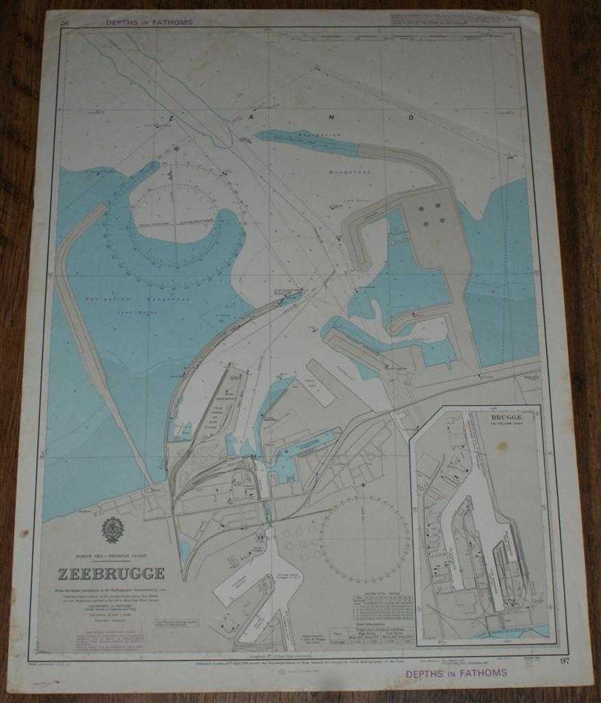
Description: Map Admiralty, 1985. Revised Edition, Softcover. Fair Condition/No Dust Jacket. Colour chart with no formal fold. Sheet is lightly marked and stained, particularly around the edges. Edges and corners are worn and slightly creased. Nautical Chart No. 97 North Sea - Belgian Coast, Zeebrugge. Copyright 1984 with small corrections to 1985. Scale 1:10,000 Area Covered: Belgium (part), Zeebrugge, Harbour and Walls, Westhoofd, Ferry and Container Terminals, North Sea (part), Boudewijnkanaal Inset plan of Brugge at same scale Size: 71x52cm. Item Type: Map. No dust jacket, as published. Single sheet map/chart which is suitable for framing and will be shipped rolled and in a cardboard tube.. Quantity Available: 1. Shipped Weight: under 1 kg. Pictures of this item not already displayed here available upon request. Inventory No: 45517021411. ISBN: 0002116448
Keywords: BZDB4 Maps; European History; naval, naval history, maritime, ships, boats. Admiralty Nautical Chart No. 97 North Sea - Belgian Coast, Zeebrugge European History naval, naval history, maritime, ships, boats
See more books from our catalog: Maps
Title: Nautical Chart No. 97 North Sea - Belgian Coast, Zeebrugge
Description: Map Admiralty, 1985. Revised Edition, Softcover. Fair Condition/No Dust Jacket. Colour chart with no formal fold. Sheet is lightly marked and stained, particularly around the edges. Edges and corners are worn and slightly creased. Nautical Chart No. 97 North Sea - Belgian Coast, Zeebrugge. Copyright 1984 with small corrections to 1985. Scale 1:10,000 Area Covered: Belgium (part), Zeebrugge, Harbour and Walls, Westhoofd, Ferry and Container Terminals, North Sea (part), Boudewijnkanaal Inset plan of Brugge at same scale Size: 71x52cm. Item Type: Map. No dust jacket, as published. Single sheet map/chart which is suitable for framing and will be shipped rolled and in a cardboard tube.. Quantity Available: 1. Shipped Weight: under 1 kg. Pictures of this item not already displayed here available upon request. Inventory No: 45517021411. ISBN: 0002116448
Keywords: BZDB4 Maps; European History; naval, naval history, maritime, ships, boats. Admiralty Nautical Chart No. 97 North Sea - Belgian Coast, Zeebrugge European History naval, naval history, maritime, ships, boats
Price: GBP 21.00 = appr. US$ 29.99 Seller: Bailgate Books Ltd
- Book number: 45517021411
- Book number: 45517021411
See more books from our catalog: Maps