Author: Admiralty
Title: Nautical Chart No. L(D3)1981 England - West Coast, Approaches to Preston
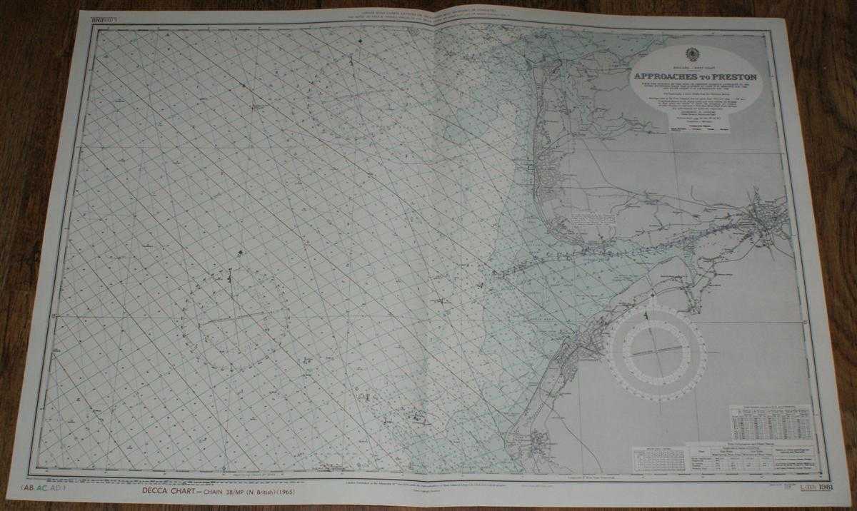
Description: Map Admiralty, 1974. Revised Edition, Softcover. Very Good Condition/No Dust Jacket. Clean and crisp colour chart with AB, AC and AD Decca lines. Single vertical fold. Nautical Chart No. L(D3)1981 England - West Coast, Approaches to Preston. From surveys to 1950 with small corrections to 1974. Scale 1:75,000 Area Covered: England (part), Preston (part), Southport, Formby, Blackpool, Fleetwood Irish Sea (part), River Ribble, River Wyre, Lune Deep, Bernard Wharf, Penfold Channel, Shell Flat Size: 71x103cm. Item Type: Map. No dust jacket, as published. Single sheet map/chart which is suitable for framing and will be shipped rolled and in a cardboard tube.. Quantity Available: 1. Shipped Weight: under 1 kg. Pictures of this item not already displayed here available upon request. Inventory No: 45517011328. ISBN: 0952054531
Keywords: BZDB4 Nautical chart, map, shipping Maps; Lancashire; naval, naval history, maritime, ships, boats. Admiralty Nautical Chart No. L(D3)1981 England - West Coast, Approaches to Preston Lancashire naval, naval history, maritime, ships, boats
See more books from our catalog: Maps
Title: Nautical Chart No. L(D3)1981 England - West Coast, Approaches to Preston
Description: Map Admiralty, 1974. Revised Edition, Softcover. Very Good Condition/No Dust Jacket. Clean and crisp colour chart with AB, AC and AD Decca lines. Single vertical fold. Nautical Chart No. L(D3)1981 England - West Coast, Approaches to Preston. From surveys to 1950 with small corrections to 1974. Scale 1:75,000 Area Covered: England (part), Preston (part), Southport, Formby, Blackpool, Fleetwood Irish Sea (part), River Ribble, River Wyre, Lune Deep, Bernard Wharf, Penfold Channel, Shell Flat Size: 71x103cm. Item Type: Map. No dust jacket, as published. Single sheet map/chart which is suitable for framing and will be shipped rolled and in a cardboard tube.. Quantity Available: 1. Shipped Weight: under 1 kg. Pictures of this item not already displayed here available upon request. Inventory No: 45517011328. ISBN: 0952054531
Keywords: BZDB4 Nautical chart, map, shipping Maps; Lancashire; naval, naval history, maritime, ships, boats. Admiralty Nautical Chart No. L(D3)1981 England - West Coast, Approaches to Preston Lancashire naval, naval history, maritime, ships, boats
Price: GBP 25.00 = appr. US$ 35.70 Seller: Bailgate Books Ltd
- Book number: 45517011328
- Book number: 45517011328
See more books from our catalog: Maps