Author: Admiralty
Title: Nautical Chart No. L(D)(MC)1410 St. Georges Channel - Carnsore Point to Braich-Y-Pwll
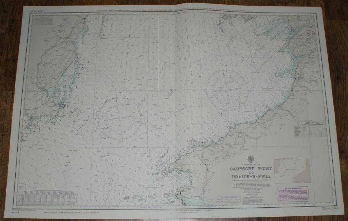
Description: Map Admiralty, 1974. Revised Edition, Softcover. Very Good Condition/No Dust Jacket. Clean and crisp coloured chart with AB, AC and AD Decca lines. Single vertical fold with slight associated and other vertical creasing. Some minor pencil annotation in upper right portion of chart. Nautical Chart No. L(D)(MC)1410 St. Georges Channel - Carnsore Point to Braich-Y-Pwll. Copyright 1973 with small corrections to 1974. Scale 1:200,000 Area Covered: Ireland (part), Wexford, Wales (part), Pembrokeshire, Cardiganshire, Merionethshire, Llyn Peninsula (tip of), Bardsey I. Aberystwyth, Cardigan,St. Davids, Milford Haven St. Georges Channel, Cardigan Bay Size: 71x103cm. Item Type: Map. No dust jacket, as published. Single sheet map/chart which is suitable for framing and will be shipped rolled and in a cardboard tube.. Quantity Available: 1. Shipped Weight: under 1 kg. Pictures of this item not already displayed here available upon request. Inventory No: 45517011301. ISBN: 0952054531
Keywords: BZDB4 Nautical chart, map, shipping Maps; Ireland; Wales and Welsh History, literature & language; naval, naval history, maritime, ships, boats. Admiralty Nautical Chart No. L(D)(MC)1410 St. Georges Channel - Carnsore Point to Braich-Y-Pwll Ireland Wales
See more books from our catalog: Maps
Title: Nautical Chart No. L(D)(MC)1410 St. Georges Channel - Carnsore Point to Braich-Y-Pwll
Description: Map Admiralty, 1974. Revised Edition, Softcover. Very Good Condition/No Dust Jacket. Clean and crisp coloured chart with AB, AC and AD Decca lines. Single vertical fold with slight associated and other vertical creasing. Some minor pencil annotation in upper right portion of chart. Nautical Chart No. L(D)(MC)1410 St. Georges Channel - Carnsore Point to Braich-Y-Pwll. Copyright 1973 with small corrections to 1974. Scale 1:200,000 Area Covered: Ireland (part), Wexford, Wales (part), Pembrokeshire, Cardiganshire, Merionethshire, Llyn Peninsula (tip of), Bardsey I. Aberystwyth, Cardigan,St. Davids, Milford Haven St. Georges Channel, Cardigan Bay Size: 71x103cm. Item Type: Map. No dust jacket, as published. Single sheet map/chart which is suitable for framing and will be shipped rolled and in a cardboard tube.. Quantity Available: 1. Shipped Weight: under 1 kg. Pictures of this item not already displayed here available upon request. Inventory No: 45517011301. ISBN: 0952054531
Keywords: BZDB4 Nautical chart, map, shipping Maps; Ireland; Wales and Welsh History, literature & language; naval, naval history, maritime, ships, boats. Admiralty Nautical Chart No. L(D)(MC)1410 St. Georges Channel - Carnsore Point to Braich-Y-Pwll Ireland Wales
Price: GBP 25.00 = appr. US$ 35.70 Seller: Bailgate Books Ltd
- Book number: 45517011301
- Book number: 45517011301
See more books from our catalog: Maps