Author: Admiralty
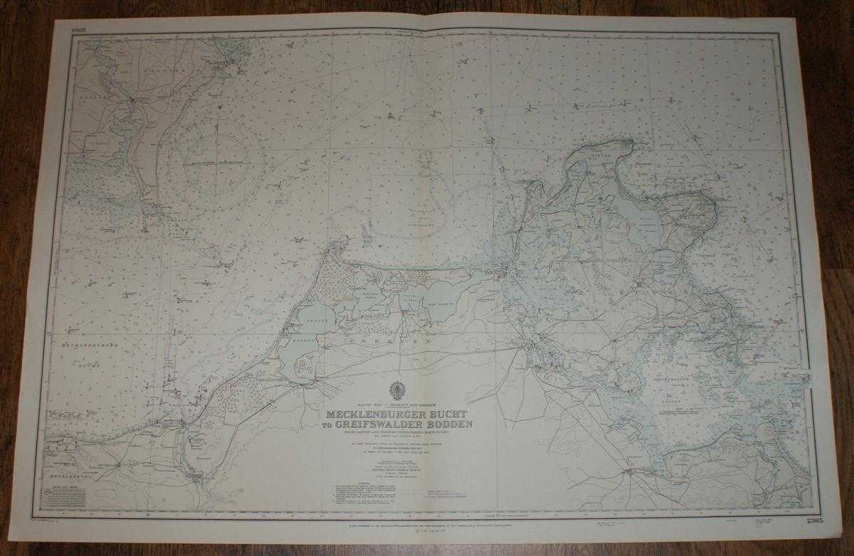
Title: Nautical Chart No. 2365, Baltic Sea - Germany and Denmark. Mecklenburger Bucht to Greifswalder Bodden from Danish and German Government Charts to 1950 with additions to 1970
Description: Map Admiralty, 1973. Revised Edition, Softcover. Very Good Condition/No Dust Jacket. Crisp clean black and white chart with horizontal and vertical folds. Two small inked stamps on reverse. Some annotations in pencil. Nautical Chart No. 2365, Baltic Sea - Germany and Denmark. Mecklenburger Bucht to Greifswalder Bodden from Danish and German Government Charts to 1950 with additions to 1970, small corrections to 1973. Scale 150,000. Area covered; Mecklenburg, Rostock, Usedom, Rugen, Jasmund, Witton, Pommer, Tromper Wiek, Greifswalder Bodder, Stralsund, Lolland, Falster,Nysted, Nykobing. Size: 1110mm x 920mm. Item Type: Map. No dust jacket, as published. Single sheet map/chart which is suitable for framing and will be shipped rolled and in a cardboard tube.. Quantity Available: 1. Shipped Weight: under 1 kg. Pictures of this item not already displayed here available upon request. Inventory No: 45516111108. ISBN: 0952632322
Keywords: BZDB4 nautical chart, shipping, Scotland Maps; Scandinavia; Germany, Austria, Switzerland and German Language; naval, naval history, maritime, ships, boats. Admiralty Nautical Chart No. 2365, Baltic Sea - Germany and Denmark. Mecklenburger Bucht to Greifs
See more books from our catalog: Maps
Title: Nautical Chart No. 2365, Baltic Sea - Germany and Denmark. Mecklenburger Bucht to Greifswalder Bodden from Danish and German Government Charts to 1950 with additions to 1970
Description: Map Admiralty, 1973. Revised Edition, Softcover. Very Good Condition/No Dust Jacket. Crisp clean black and white chart with horizontal and vertical folds. Two small inked stamps on reverse. Some annotations in pencil. Nautical Chart No. 2365, Baltic Sea - Germany and Denmark. Mecklenburger Bucht to Greifswalder Bodden from Danish and German Government Charts to 1950 with additions to 1970, small corrections to 1973. Scale 150,000. Area covered; Mecklenburg, Rostock, Usedom, Rugen, Jasmund, Witton, Pommer, Tromper Wiek, Greifswalder Bodder, Stralsund, Lolland, Falster,Nysted, Nykobing. Size: 1110mm x 920mm. Item Type: Map. No dust jacket, as published. Single sheet map/chart which is suitable for framing and will be shipped rolled and in a cardboard tube.. Quantity Available: 1. Shipped Weight: under 1 kg. Pictures of this item not already displayed here available upon request. Inventory No: 45516111108. ISBN: 0952632322
Keywords: BZDB4 nautical chart, shipping, Scotland Maps; Scandinavia; Germany, Austria, Switzerland and German Language; naval, naval history, maritime, ships, boats. Admiralty Nautical Chart No. 2365, Baltic Sea - Germany and Denmark. Mecklenburger Bucht to Greifs
Price: GBP 24.00 = appr. US$ 34.27 Seller: Bailgate Books Ltd
- Book number: 45516111108
- Book number: 45516111108
See more books from our catalog: Maps