Author: Admiralty
Title: Nautical Chart No. 2469, Schleswig-Hostein, Der Nord - Ostee Kanal, various scales
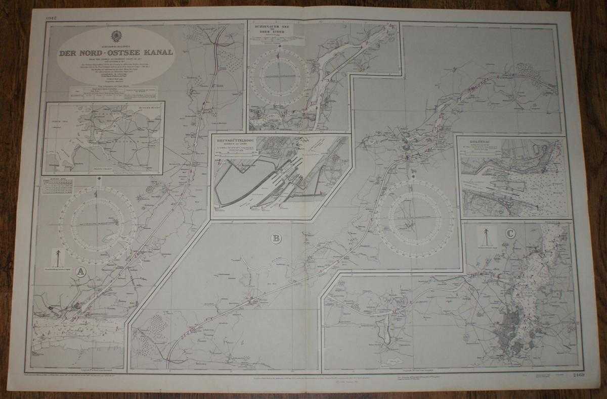
Description: Map Admiralty, London, 1972. Revised Edition, Softcover. Very Good Condition/No Dust Jacket. Crisp clean black and white chart with single vertical fold. Small inked stamp on reverse. Nautical Chart No. 2469, Schleswig-Hostein, Der Nord - Ostee Kanal, various scales. From the German Government Chart of 1917. Large corrections to 1961, small corrections to 1973. Includes: Index plan 3 plans showing length of Kanal, Scale 1:51,400; Schirder See to Ober Eider, Scale 1:25,000; Brunsbuttelkoog Harbour and Locks, Scale 1:10,000; Holtenau Harbour and Locks, Scale 1:10,000. Area covered includes: Kiel; Kieler Hafen; Rendsburg; Oldenbuttel; Brunsbuttel, Die Elbe (part). Size: 1040mm x 710mm. Item Type: Map. No dust jacket, as published. Single sheet map/chart which is suitable for framing and will be shipped rolled and in a cardboard tube.. Quantity Available: 1. Shipped Weight: under 1 kg. Pictures of this item not already displayed here available upon request. Inventory No: 45516111040. ISBN: 0948265795
Keywords: BZDB4 nautical chart, shipping, Germany Maps; Germany, Austria, Switzerland and German Language; naval, naval history, maritime, ships, boats. Admiralty Nautical Chart No. 2469, Schleswig-Hostein, Der Nord - Ostee Kanal, various scales Germany, Austria, S
See more books from our catalog: Maps
Title: Nautical Chart No. 2469, Schleswig-Hostein, Der Nord - Ostee Kanal, various scales
Description: Map Admiralty, London, 1972. Revised Edition, Softcover. Very Good Condition/No Dust Jacket. Crisp clean black and white chart with single vertical fold. Small inked stamp on reverse. Nautical Chart No. 2469, Schleswig-Hostein, Der Nord - Ostee Kanal, various scales. From the German Government Chart of 1917. Large corrections to 1961, small corrections to 1973. Includes: Index plan 3 plans showing length of Kanal, Scale 1:51,400; Schirder See to Ober Eider, Scale 1:25,000; Brunsbuttelkoog Harbour and Locks, Scale 1:10,000; Holtenau Harbour and Locks, Scale 1:10,000. Area covered includes: Kiel; Kieler Hafen; Rendsburg; Oldenbuttel; Brunsbuttel, Die Elbe (part). Size: 1040mm x 710mm. Item Type: Map. No dust jacket, as published. Single sheet map/chart which is suitable for framing and will be shipped rolled and in a cardboard tube.. Quantity Available: 1. Shipped Weight: under 1 kg. Pictures of this item not already displayed here available upon request. Inventory No: 45516111040. ISBN: 0948265795
Keywords: BZDB4 nautical chart, shipping, Germany Maps; Germany, Austria, Switzerland and German Language; naval, naval history, maritime, ships, boats. Admiralty Nautical Chart No. 2469, Schleswig-Hostein, Der Nord - Ostee Kanal, various scales Germany, Austria, S
Price: GBP 24.00 = appr. US$ 34.27 Seller: Bailgate Books Ltd
- Book number: 45516111040
- Book number: 45516111040
See more books from our catalog: Maps