Author: Admiralty
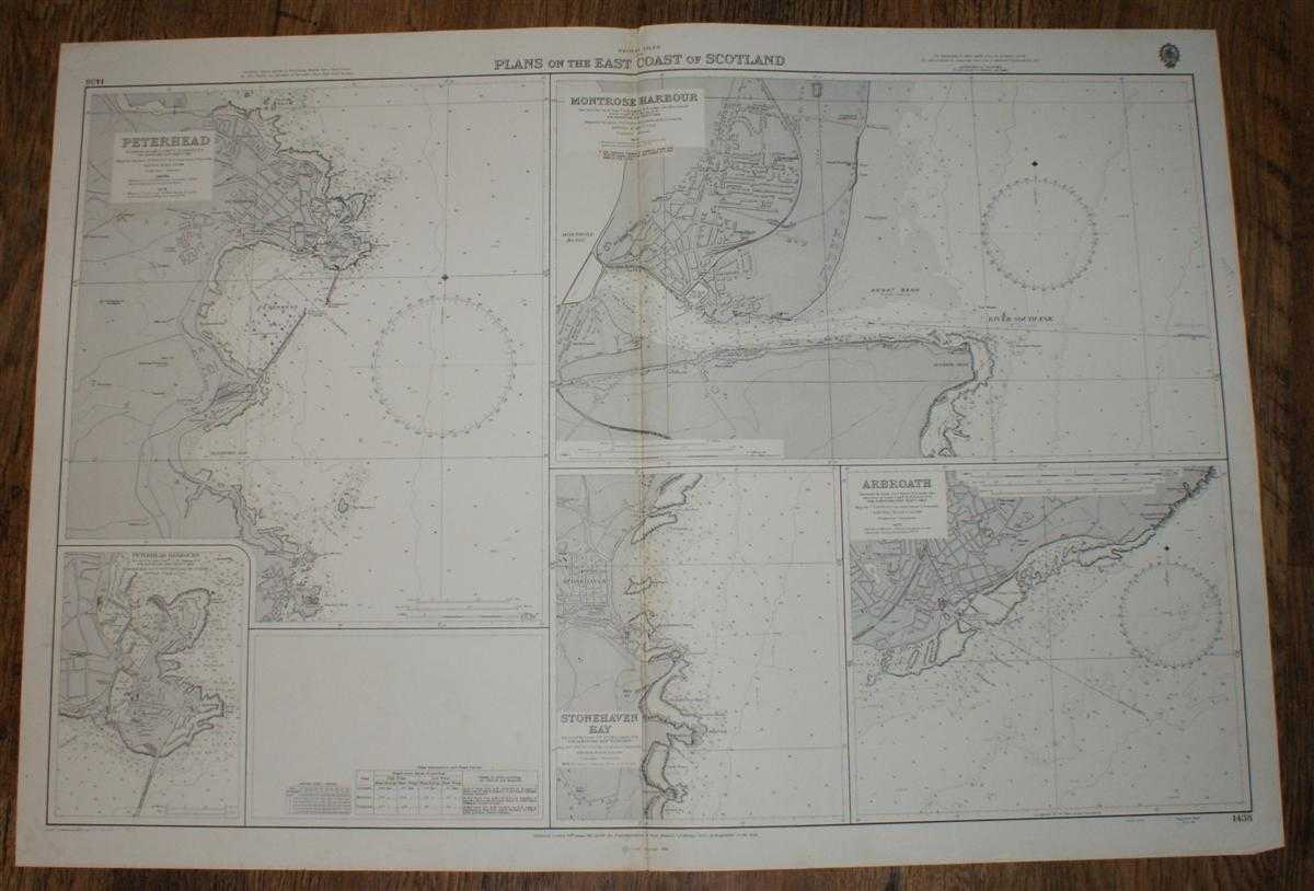
Title: Nautical Chart No. 1438, British Isles, Plans on the East Coast of Scotland: Peterhead, Peterhead Harbours, Montrose, Arbroath, Stonehaven Bay. Various Scales
Description: Map Admiralty, London, 1974. Revised Edition, Softcover. Very Good Condition/No Dust Jacket. Crisp clean coloured chart. with five distinct plans and single vertical fold. Lower edge is lightly worn with a short marginal crease across lower right corner. Small inked stamp on reverse. Nautical Chart No. 1438, British Isles, Plans on the East Coast of Scotland: Peterhead, Sclae 1:12,000; Peterhead Harbours, Scale 1: 6,000; Montrose, Scale 1:7,500; Arbroath, Scale 1:12,500; Stonehaven Bay, Scale 1:12,500. Small corrections to 1974. Copyright 1966. Size: 1040mm x 710mm. Item Type: Map. No dust jacket, as published. Single sheet map/chart which is suitable for framing and will be shipped rolled and in a cardboard tube.. Quantity Available: 1. Shipped Weight: under 1 kg. Pictures of this item not already displayed here available upon request. Inventory No: 45516111036. ISBN: 0948265795
Keywords: BZDB4 nautical chart, shipping, Scotland Maps; Scotland; naval, naval history, maritime, ships, boats. Admiralty Nautical Chart No. 1438, British Isles, Plans on the East Coast of Scotland: Peterhead, Peterhead Harbours, Montrose, Arbroath, Stonehaven Bay
See more books from our catalog: Maps
Title: Nautical Chart No. 1438, British Isles, Plans on the East Coast of Scotland: Peterhead, Peterhead Harbours, Montrose, Arbroath, Stonehaven Bay. Various Scales
Description: Map Admiralty, London, 1974. Revised Edition, Softcover. Very Good Condition/No Dust Jacket. Crisp clean coloured chart. with five distinct plans and single vertical fold. Lower edge is lightly worn with a short marginal crease across lower right corner. Small inked stamp on reverse. Nautical Chart No. 1438, British Isles, Plans on the East Coast of Scotland: Peterhead, Sclae 1:12,000; Peterhead Harbours, Scale 1: 6,000; Montrose, Scale 1:7,500; Arbroath, Scale 1:12,500; Stonehaven Bay, Scale 1:12,500. Small corrections to 1974. Copyright 1966. Size: 1040mm x 710mm. Item Type: Map. No dust jacket, as published. Single sheet map/chart which is suitable for framing and will be shipped rolled and in a cardboard tube.. Quantity Available: 1. Shipped Weight: under 1 kg. Pictures of this item not already displayed here available upon request. Inventory No: 45516111036. ISBN: 0948265795
Keywords: BZDB4 nautical chart, shipping, Scotland Maps; Scotland; naval, naval history, maritime, ships, boats. Admiralty Nautical Chart No. 1438, British Isles, Plans on the East Coast of Scotland: Peterhead, Peterhead Harbours, Montrose, Arbroath, Stonehaven Bay
Price: GBP 24.00 = appr. US$ 34.27 Seller: Bailgate Books Ltd
- Book number: 45516111036
- Book number: 45516111036
See more books from our catalog: Maps