Author: Admiralty
Title: Nautical Chart No. 696. Baltic Sea, Germany, Kieler Hafen. Scale 1:12,500
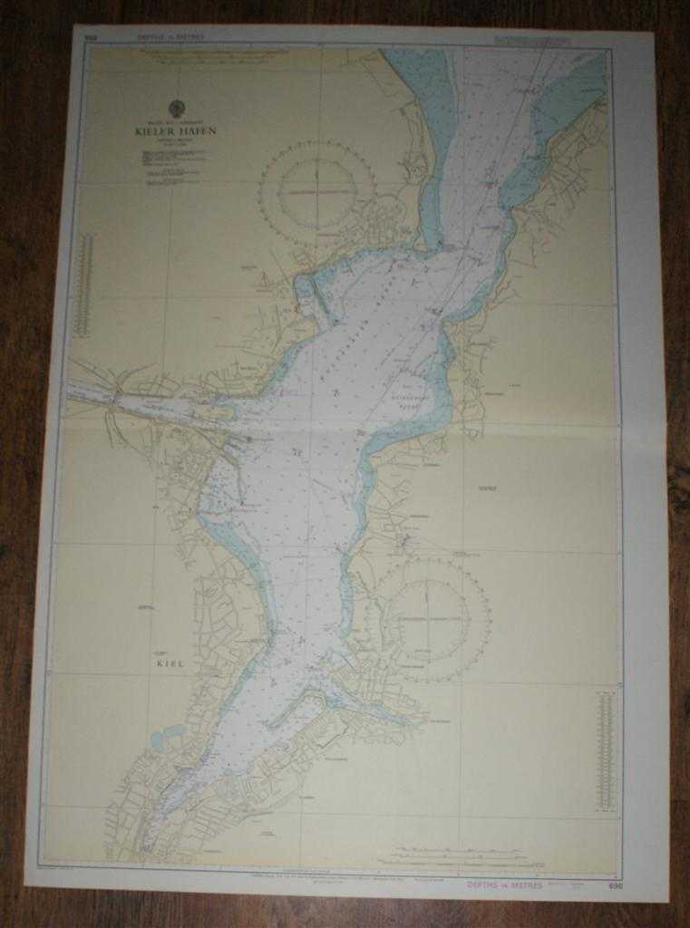
Description: Map Admiralty, London, 1973. Revised Edition, Softcover. Very Good Condition/No Dust Jacket. Crisp clean coloured chart. Small inked stamp on reverse. Single horizontal fold. Bearings added in pencil. Nautical Chart No. 696. Baltic Sea, Germany, Kieler Hafen. Scale 1:12,500. Compiled from German Charts to 1971. New edition 1972, small corrections to 1973. Area covered: Friedrichsort, Holtenau, Kiel, Gaarden, Schusterkrug, Ellerbek, Wellingdorf, Neumuhlen, Dietrichsdorf, Monkeberg, Heikendorf, Moltenort, Laboe, Holtenauer Reede. Size: 1040mm x 710mm. Item Type: Map. No dust jacket, as published. Single sheet map/chart which is suitable for framing and will be shipped rolled and in a cardboard tube.. Quantity Available: 1. Shipped Weight: under 1 kg. Pictures of this item not already displayed here available upon request. Inventory No: 45516111019. ISBN: 0948265795
Keywords: BZDB4 nautical chart, shipping, Maps; Germany, Austria, Switzerland and German Language; naval, naval history, maritime, ships, boats. Admiralty Nautical Chart No. 696. Baltic Sea, Germany, Kieler Hafen. Scale 1:12,500 Germany, Austria, Switzerland and Ge
See more books from our catalog: Maps
Title: Nautical Chart No. 696. Baltic Sea, Germany, Kieler Hafen. Scale 1:12,500
Description: Map Admiralty, London, 1973. Revised Edition, Softcover. Very Good Condition/No Dust Jacket. Crisp clean coloured chart. Small inked stamp on reverse. Single horizontal fold. Bearings added in pencil. Nautical Chart No. 696. Baltic Sea, Germany, Kieler Hafen. Scale 1:12,500. Compiled from German Charts to 1971. New edition 1972, small corrections to 1973. Area covered: Friedrichsort, Holtenau, Kiel, Gaarden, Schusterkrug, Ellerbek, Wellingdorf, Neumuhlen, Dietrichsdorf, Monkeberg, Heikendorf, Moltenort, Laboe, Holtenauer Reede. Size: 1040mm x 710mm. Item Type: Map. No dust jacket, as published. Single sheet map/chart which is suitable for framing and will be shipped rolled and in a cardboard tube.. Quantity Available: 1. Shipped Weight: under 1 kg. Pictures of this item not already displayed here available upon request. Inventory No: 45516111019. ISBN: 0948265795
Keywords: BZDB4 nautical chart, shipping, Maps; Germany, Austria, Switzerland and German Language; naval, naval history, maritime, ships, boats. Admiralty Nautical Chart No. 696. Baltic Sea, Germany, Kieler Hafen. Scale 1:12,500 Germany, Austria, Switzerland and Ge
Price: GBP 24.00 = appr. US$ 34.27 Seller: Bailgate Books Ltd
- Book number: 45516111019
- Book number: 45516111019
See more books from our catalog: Maps