Author: John Bartholomew
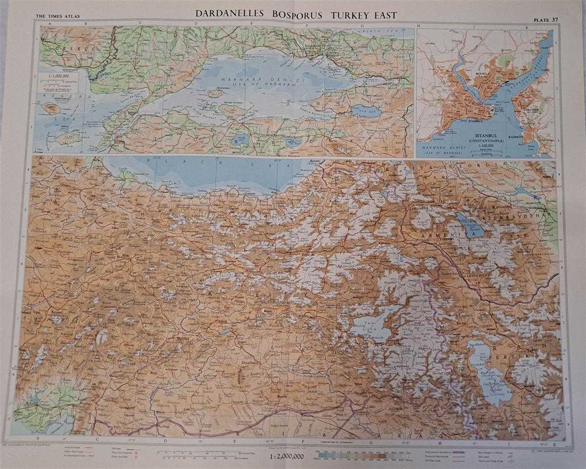
Title: Map of Dardanelles, Bosphorus, Turkey east, Plate 37 disbound from 1959 Mid-Century Times Atlas of the World, Volume II, (South-West Asia & Russia) Scale 1: 2,000,000; Marmara Den 1:1,000,000; Istanbul (Constantinople) 1:100,000
Description: The Times Publishing Company Ltd. London, 1959. Mid-Century Edition, Softcover. Fine Condition/No Dust Jacket. Single disbound map sheet from 'The Times Atlas of the World, Mid-Century Edition; Volume II Eurasia, suitable for framing. Map is in colour and has vertical centre fold. Approx. sheet size is 49 x 61cm. Sheet is clean, bright and crisp. Scale 1:2,000,000. Map shows relief, national boundaries, cities, town, rivers, main roads, railways, main civil airports and other airfields,salt lakes, marsh, oil pipe lines, archaeological Sites Inset map of the Dardanelles, Sea of Marmara and Bosphorus Scale 1:1,000,000, includes small part of Greece. Small inset plan of Istanbul, scale 1:100,000, shows Ferry routes, fortified walls, public buildings. Key map on reverse. First printing of this edition. Quantity Available: 1. Shipped Weight: under 1 kg. Pictures of this item not already displayed here available upon request. Inventory No: 45022081070. ISBN: 0333371852
Keywords: BZDB4 Maps; European History; Geology, geography, mineralogy, environment; Middle-East, Turkey, Greece, Cyprus & Egypt. Unbranded John Bartholomew Map of Dardanelles, Bosphorus, Turkey east, Plate 37 disbound from 1959 Mid-Century Times Atlas of the World
See more books from our catalog: Maps
Title: Map of Dardanelles, Bosphorus, Turkey east, Plate 37 disbound from 1959 Mid-Century Times Atlas of the World, Volume II, (South-West Asia & Russia) Scale 1: 2,000,000; Marmara Den 1:1,000,000; Istanbul (Constantinople) 1:100,000
Description: The Times Publishing Company Ltd. London, 1959. Mid-Century Edition, Softcover. Fine Condition/No Dust Jacket. Single disbound map sheet from 'The Times Atlas of the World, Mid-Century Edition; Volume II Eurasia, suitable for framing. Map is in colour and has vertical centre fold. Approx. sheet size is 49 x 61cm. Sheet is clean, bright and crisp. Scale 1:2,000,000. Map shows relief, national boundaries, cities, town, rivers, main roads, railways, main civil airports and other airfields,salt lakes, marsh, oil pipe lines, archaeological Sites Inset map of the Dardanelles, Sea of Marmara and Bosphorus Scale 1:1,000,000, includes small part of Greece. Small inset plan of Istanbul, scale 1:100,000, shows Ferry routes, fortified walls, public buildings. Key map on reverse. First printing of this edition. Quantity Available: 1. Shipped Weight: under 1 kg. Pictures of this item not already displayed here available upon request. Inventory No: 45022081070. ISBN: 0333371852
Keywords: BZDB4 Maps; European History; Geology, geography, mineralogy, environment; Middle-East, Turkey, Greece, Cyprus & Egypt. Unbranded John Bartholomew Map of Dardanelles, Bosphorus, Turkey east, Plate 37 disbound from 1959 Mid-Century Times Atlas of the World
Price: GBP 28.00 = appr. US$ 39.98 Seller: Bailgate Books Ltd
- Book number: 45022081070
- Book number: 45022081070
See more books from our catalog: Maps