Author: John Bartholomew
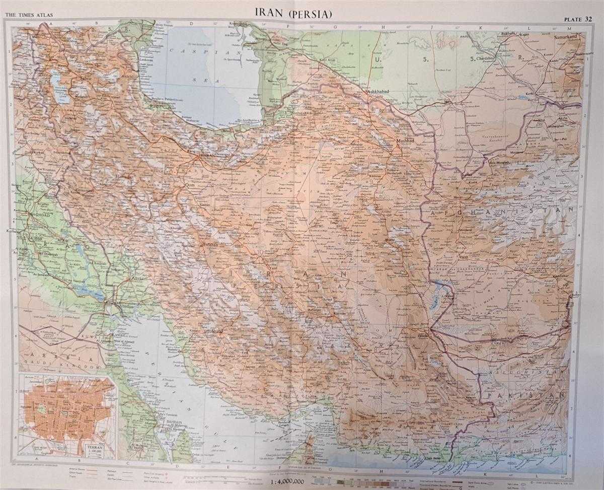
Title: Map of 'Iran (Persia)', Plate 32 disbound from 1959 Mid-Century Times Atlas of the World, Volume II, (South-West Asia and Russia) includes Iran Scale 1:4,000,000 with part of Iraq etc. and Inset plan of Tehran Scale 1:100,000
Description: The Times Publishing Company Ltd. London, 1959. Mid-Century Edition, Softcover. Fine Condition/No Dust Jacket. Single disbound map sheet from 'The Times Atlas of the World, Mid-Century Edition; Volume II Eurasia, suitable for framing. Map is in colour and has vertical centre fold. Approx. sheet size is 49 x 61cm. Sheet is clean, bright and crisp. Scale 1:4,000,000. Map shows relief, national and other boundaries, cities, town, rivers main roads, some tracks, railways, main civil airports and other airfields, sand dune areas, dry salt lakes, salt lakes, salt waste, marsh and flood areas, Ancient sites, wells, oil pipe lines. Inset plan of Tehran at 1:100,000 show main routes, railway lines and stations, embassies, green areas, mosques, airport, civic buildings, barracks, palaces. Includes : Kuwait, Bahrain, Strait of Hormuz and parts of Qatar, Arabia, Iraq, U.S.S.R. Afghanistan, Pakistan, Persian Gulf and Caspian Sea. First printing of this edition. Quantity Available: 1. Shipped Weight: under 1 kg. Pictures of this item not already displayed here available upon request. Inventory No: 45022081065. ISBN: 0333371852
Keywords: BZDB4 Maps; Geology, geography, mineralogy, environment; Middle-East, Turkey, Greece, Cyprus & Egypt. Unbranded John Bartholomew Map of 'Iran (Persia)', Plate 32 disbound from 1959 Mid-Century Times Atlas of the World, Volume II, (South-West Asia and Russ
See more books from our catalog: Maps
Title: Map of 'Iran (Persia)', Plate 32 disbound from 1959 Mid-Century Times Atlas of the World, Volume II, (South-West Asia and Russia) includes Iran Scale 1:4,000,000 with part of Iraq etc. and Inset plan of Tehran Scale 1:100,000
Description: The Times Publishing Company Ltd. London, 1959. Mid-Century Edition, Softcover. Fine Condition/No Dust Jacket. Single disbound map sheet from 'The Times Atlas of the World, Mid-Century Edition; Volume II Eurasia, suitable for framing. Map is in colour and has vertical centre fold. Approx. sheet size is 49 x 61cm. Sheet is clean, bright and crisp. Scale 1:4,000,000. Map shows relief, national and other boundaries, cities, town, rivers main roads, some tracks, railways, main civil airports and other airfields, sand dune areas, dry salt lakes, salt lakes, salt waste, marsh and flood areas, Ancient sites, wells, oil pipe lines. Inset plan of Tehran at 1:100,000 show main routes, railway lines and stations, embassies, green areas, mosques, airport, civic buildings, barracks, palaces. Includes : Kuwait, Bahrain, Strait of Hormuz and parts of Qatar, Arabia, Iraq, U.S.S.R. Afghanistan, Pakistan, Persian Gulf and Caspian Sea. First printing of this edition. Quantity Available: 1. Shipped Weight: under 1 kg. Pictures of this item not already displayed here available upon request. Inventory No: 45022081065. ISBN: 0333371852
Keywords: BZDB4 Maps; Geology, geography, mineralogy, environment; Middle-East, Turkey, Greece, Cyprus & Egypt. Unbranded John Bartholomew Map of 'Iran (Persia)', Plate 32 disbound from 1959 Mid-Century Times Atlas of the World, Volume II, (South-West Asia and Russ
Price: GBP 28.00 = appr. US$ 39.98 Seller: Bailgate Books Ltd
- Book number: 45022081065
- Book number: 45022081065
See more books from our catalog: Maps