Author: John Bartholomew
Title: Map of New Zealand - Plate 11 disbound from 1958 Mid-Century Times Atlas of the World
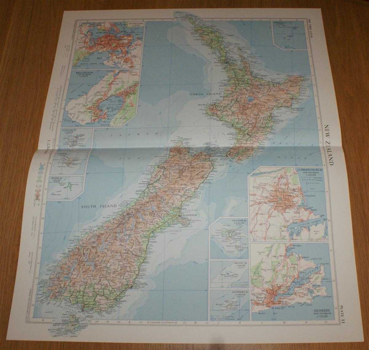
Description: The Times Publishing Company Ltd. London, 1958. Mid-Century Edition, Softcover. Very Good Condition/No Dust Jacket. Single disbound map sheet from 'The Times Atlas of the World, Mid-Century Edition; Volume I The World, Australia & East Asia' suitable for framing. Map is in colour and has horizontal centre fold. Approx sheet size is 61 x 49cm. Sheet is clean, bright and crisp. Sheet covers the whole of New Zealand and contains four inset plans at closer scale showing Auckland, Wellington, Christchurch and Dunedin; and six further small inset maps showing Chatham Island, Bounty Island, Antipodes Island, Auckland Island, Campbell Island and Snares Island. Road and rail routes are shown. First printing of this edition. Quantity Available: 1. Shipped Weight: under 1 kg. Pictures of this item not already displayed here available upon request. Inventory No: 45021024035. ISBN: 0718132130
Keywords: BZDB4 Maps; Geology, geography, mineralogy, environment; Australasia and the Pacific. John Bartholomew Map of New Zealand - Plate 11 disbound from 1958 Mid-Century Times Atlas of the World Geology, geography, mineralogy, environment Australasia and the
See more books from our catalog: Maps
Title: Map of New Zealand - Plate 11 disbound from 1958 Mid-Century Times Atlas of the World
Description: The Times Publishing Company Ltd. London, 1958. Mid-Century Edition, Softcover. Very Good Condition/No Dust Jacket. Single disbound map sheet from 'The Times Atlas of the World, Mid-Century Edition; Volume I The World, Australia & East Asia' suitable for framing. Map is in colour and has horizontal centre fold. Approx sheet size is 61 x 49cm. Sheet is clean, bright and crisp. Sheet covers the whole of New Zealand and contains four inset plans at closer scale showing Auckland, Wellington, Christchurch and Dunedin; and six further small inset maps showing Chatham Island, Bounty Island, Antipodes Island, Auckland Island, Campbell Island and Snares Island. Road and rail routes are shown. First printing of this edition. Quantity Available: 1. Shipped Weight: under 1 kg. Pictures of this item not already displayed here available upon request. Inventory No: 45021024035. ISBN: 0718132130
Keywords: BZDB4 Maps; Geology, geography, mineralogy, environment; Australasia and the Pacific. John Bartholomew Map of New Zealand - Plate 11 disbound from 1958 Mid-Century Times Atlas of the World Geology, geography, mineralogy, environment Australasia and the
Price: GBP 26.00 = appr. US$ 37.13 Seller: Bailgate Books Ltd
- Book number: 45021024035
- Book number: 45021024035
See more books from our catalog: Maps