Author: John Bartholomew
Title: Map of Palestine - Sheet 43 disbound from the 1890 'The Library Reference Atlas of the World' from Surafend (Sarafand) to the Dead Sea, including Tyre, Jerusalem and Beersheba
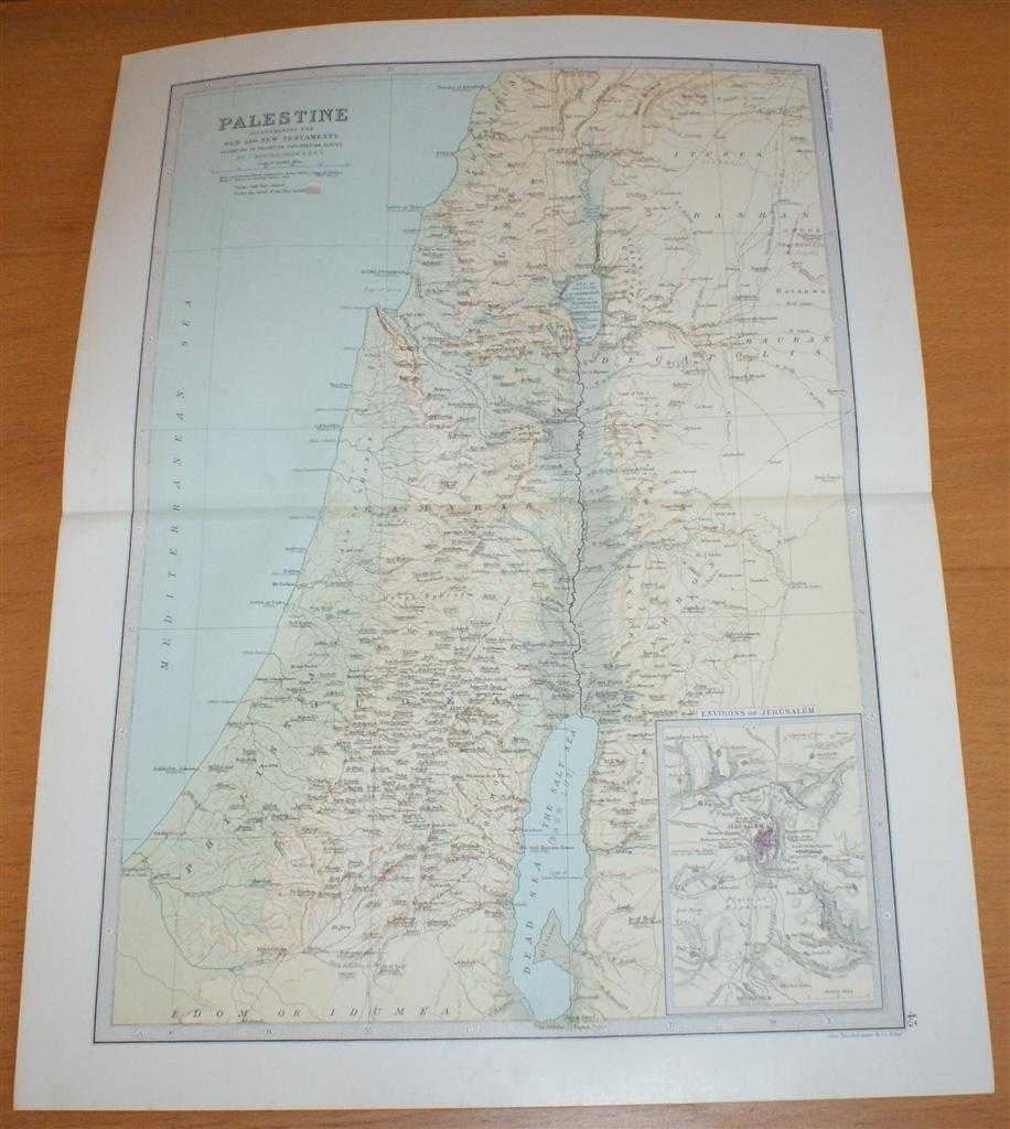
Description: Macmillan and Co. London, 1890. First Edition, Softcover. Very Good Condition/No Dust Jacket. Single disbound coloured map sheet, from John Bartholomew's Library Reference Atlas. Suitable for framing. Approx size 46 x 35cm, horizontal centre fold. Occasional light foxing in margins and at fold, map is otherwise clean, crisp and bright. Map is centred on the River Jordan and includes the Dead Sea or Salt Sea, the Sea of Galilee, the Waters of Meron, Tyre, Accho Ptolemais (Acre), Caesarea, Haifa, Joppa or Japha (Jaffa/Tel Aviv), Ashkelon, Gaza, Jerusalem, Hebron, Mount Hermon and Rabbath Ammon (Amman). Map covers modern day West Bank and Gaza and parts of Israel, Syria, Lebanon and Jordon. Sheet contains inset map of Environs of Jerusalem at closer scale. No dust jacket, as published. Quantity Available: 1. Shipped Weight: under 1 kg. Pictures of this item not already displayed here available upon request. Inventory No: 45021014039. ISBN: 0718132130
Keywords: BZDB4 Maps; World History; Religion and Theology; Middle-East, Turkey, Greece, Cyprus & Egypt. John Bartholomew Map of Palestine - Sheet 43 disbound from the 1890 'The Library Reference Atlas of the World' from Surafend (Sarafand) to the Dead Sea, includi
See more books from our catalog: Maps
Title: Map of Palestine - Sheet 43 disbound from the 1890 'The Library Reference Atlas of the World' from Surafend (Sarafand) to the Dead Sea, including Tyre, Jerusalem and Beersheba
Description: Macmillan and Co. London, 1890. First Edition, Softcover. Very Good Condition/No Dust Jacket. Single disbound coloured map sheet, from John Bartholomew's Library Reference Atlas. Suitable for framing. Approx size 46 x 35cm, horizontal centre fold. Occasional light foxing in margins and at fold, map is otherwise clean, crisp and bright. Map is centred on the River Jordan and includes the Dead Sea or Salt Sea, the Sea of Galilee, the Waters of Meron, Tyre, Accho Ptolemais (Acre), Caesarea, Haifa, Joppa or Japha (Jaffa/Tel Aviv), Ashkelon, Gaza, Jerusalem, Hebron, Mount Hermon and Rabbath Ammon (Amman). Map covers modern day West Bank and Gaza and parts of Israel, Syria, Lebanon and Jordon. Sheet contains inset map of Environs of Jerusalem at closer scale. No dust jacket, as published. Quantity Available: 1. Shipped Weight: under 1 kg. Pictures of this item not already displayed here available upon request. Inventory No: 45021014039. ISBN: 0718132130
Keywords: BZDB4 Maps; World History; Religion and Theology; Middle-East, Turkey, Greece, Cyprus & Egypt. John Bartholomew Map of Palestine - Sheet 43 disbound from the 1890 'The Library Reference Atlas of the World' from Surafend (Sarafand) to the Dead Sea, includi
Price: GBP 37.00 = appr. US$ 52.84 Seller: Bailgate Books Ltd
- Book number: 45021014039
- Book number: 45021014039
See more books from our catalog: Maps