Author: John Bartholomew
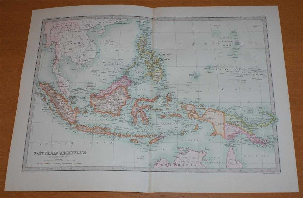
Title: Map of 'East Indian Archipelago' - Sheet 50 disbound from the 1890 'The Library Reference Atlas of the World' covering Indonesia and the Philippines, etc.
Description: Macmillan and Co. London, 1890. First Edition, Softcover. Very Good Condition/No Dust Jacket. Single disbound coloured map sheet, from John Bartholomew's Library Reference Atlas. Suitable for framing. Approx size 35 x 46cm, vertical centre fold. Map is clean, crisp and bright. Map includes Sumatra, Java, Siam, Borneo, Celebes, Philippine Islands, Moluccas, New Guinea, Timor, Caroline Islands, Marianne or Ladrones Islands, Hainan, Anam, French Cochin China, Bismark Archipelago and northern parts of Australia. This covers modern day Indonesia, Singapore, Malaysia, Papua New Guinea, Thailand, Coambodia and Vietnam. No dust jacket, as published. Quantity Available: 1. Shipped Weight: under 1 kg. Pictures of this item not already displayed here available upon request. Inventory No: 45021014035. ISBN: 0718132130
Keywords: BZDB4 Maps; Australasia and the Pacific; World History; Indian sub-continent & South East Asia. John Bartholomew Map of 'East Indian Archipelago' - Sheet 50 disbound from the 1890 'The Library Reference Atlas of the World' covering Indonesia and the Phili
See more books from our catalog: Maps
Title: Map of 'East Indian Archipelago' - Sheet 50 disbound from the 1890 'The Library Reference Atlas of the World' covering Indonesia and the Philippines, etc.
Description: Macmillan and Co. London, 1890. First Edition, Softcover. Very Good Condition/No Dust Jacket. Single disbound coloured map sheet, from John Bartholomew's Library Reference Atlas. Suitable for framing. Approx size 35 x 46cm, vertical centre fold. Map is clean, crisp and bright. Map includes Sumatra, Java, Siam, Borneo, Celebes, Philippine Islands, Moluccas, New Guinea, Timor, Caroline Islands, Marianne or Ladrones Islands, Hainan, Anam, French Cochin China, Bismark Archipelago and northern parts of Australia. This covers modern day Indonesia, Singapore, Malaysia, Papua New Guinea, Thailand, Coambodia and Vietnam. No dust jacket, as published. Quantity Available: 1. Shipped Weight: under 1 kg. Pictures of this item not already displayed here available upon request. Inventory No: 45021014035. ISBN: 0718132130
Keywords: BZDB4 Maps; Australasia and the Pacific; World History; Indian sub-continent & South East Asia. John Bartholomew Map of 'East Indian Archipelago' - Sheet 50 disbound from the 1890 'The Library Reference Atlas of the World' covering Indonesia and the Phili
Price: GBP 36.00 = appr. US$ 51.41 Seller: Bailgate Books Ltd
- Book number: 45021014035
- Book number: 45021014035
See more books from our catalog: Maps