Author: John Bartholomew
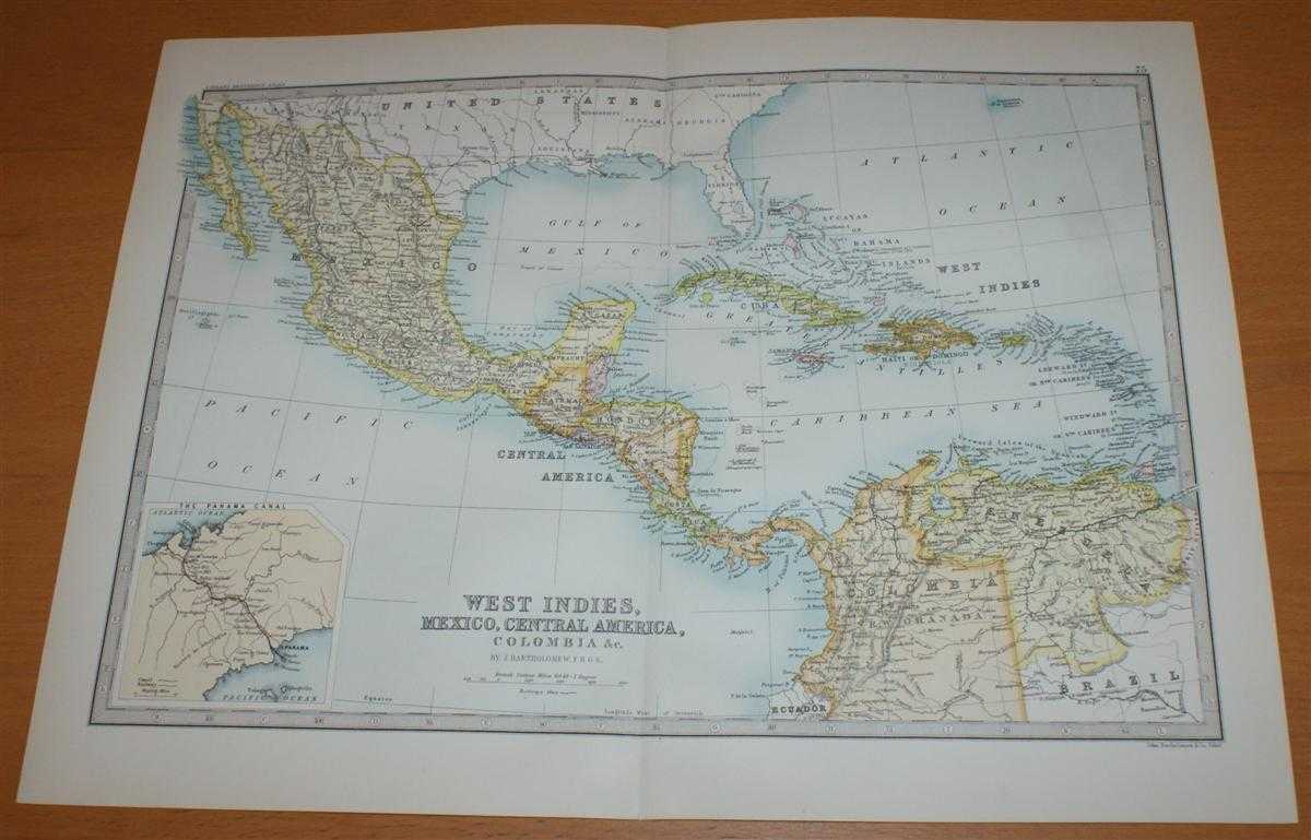
Title: Map of the West Indies, Mexico and Central America - Sheet 75 disbound from the 1890 'The Library Reference Atlas of the World' including the Gulf of Mexico, the Caribbean Sea and the Panama Canal
Description: Macmillan and Co. London, 1890. First Edition, Softcover. Very Good Condition/No Dust Jacket. Single disbound coloured map sheet, from John Bartholomew's Library Reference Atlas covering the Caribbean and Central America. Suitable for framing. Approx size 35 x 46cm, vertical centre fold. Map is clean, crisp and bright. Coloured parts of the map include Mexico, Guatemala, Yucatan, Honduras, British Honduras, San Salvador, Nicaragua, Costa Rica, Cuba, Jamaica, Haiti or S. Domingo, Puerto Rica, Bahama Islands, Bermudas, Trinidad, Windward and Leeward Islands, Venezuela and part of Colombia (New Granada). Inset plan at larger scale showing the Panama Canal in bottom left corner of sheet. Also included is Florida, Louisiana and part of Texas. No dust jacket, as published. Quantity Available: 1. Shipped Weight: under 1 kg. Pictures of this item not already displayed here available upon request. Inventory No: 45021014025. ISBN: 0718132130
Keywords: BZDB4 Maps; World History; Geology, geography, mineralogy, environment; South & Central America & the West Indies. John Bartholomew Map of the West Indies, Mexico and Central America - Sheet 75 disbound from the 1890 'The Library Reference Atlas of the Wo
See more books from our catalog: Maps
Title: Map of the West Indies, Mexico and Central America - Sheet 75 disbound from the 1890 'The Library Reference Atlas of the World' including the Gulf of Mexico, the Caribbean Sea and the Panama Canal
Description: Macmillan and Co. London, 1890. First Edition, Softcover. Very Good Condition/No Dust Jacket. Single disbound coloured map sheet, from John Bartholomew's Library Reference Atlas covering the Caribbean and Central America. Suitable for framing. Approx size 35 x 46cm, vertical centre fold. Map is clean, crisp and bright. Coloured parts of the map include Mexico, Guatemala, Yucatan, Honduras, British Honduras, San Salvador, Nicaragua, Costa Rica, Cuba, Jamaica, Haiti or S. Domingo, Puerto Rica, Bahama Islands, Bermudas, Trinidad, Windward and Leeward Islands, Venezuela and part of Colombia (New Granada). Inset plan at larger scale showing the Panama Canal in bottom left corner of sheet. Also included is Florida, Louisiana and part of Texas. No dust jacket, as published. Quantity Available: 1. Shipped Weight: under 1 kg. Pictures of this item not already displayed here available upon request. Inventory No: 45021014025. ISBN: 0718132130
Keywords: BZDB4 Maps; World History; Geology, geography, mineralogy, environment; South & Central America & the West Indies. John Bartholomew Map of the West Indies, Mexico and Central America - Sheet 75 disbound from the 1890 'The Library Reference Atlas of the Wo
Price: GBP 38.00 = appr. US$ 54.26 Seller: Bailgate Books Ltd
- Book number: 45021014025
- Book number: 45021014025
See more books from our catalog: Maps