Author: John Bartholomew
Title: Map of The North and South Polar Regions, including Siberia, Greenland and Alaska - Sheet 8, disbound from the 1890 'The Library Reference Atlas of the World' (Antarctica and the Arctic)
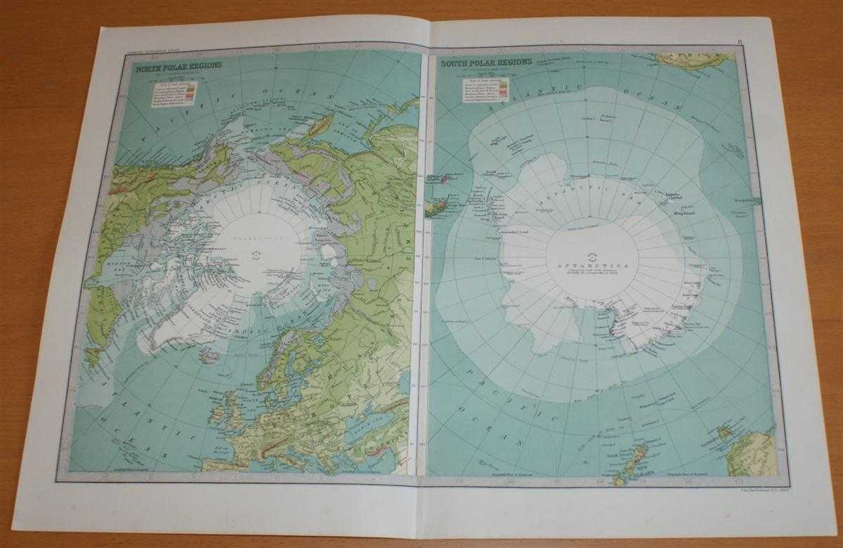
Description: Macmillan and Co. London, 1890. First Edition, Softcover. Very Good Condition/No Dust Jacket. Single disbound coloured map sheet, from John Bartholomew's Library Reference Atlas. Suitable for framing. Approx size 35 x 46cm, vertical centre fold. Ocassional light foxing, map is otherwise clean, crisp, clear and bright. Sheet is divided into two panels, North Polar Regions and South Polar Regions. The areas directly surrounding both poles are marked as 'unexplored'. North includes; Arctic Ocean, North Pole, Greenland, Iceland, Scandinavia, Alaska, British Isles, Kara Sea, Behring Sea, Hudson Bay, Sea of Okhotsk, etc. South includes; Antarctic Sea, South Pole, Cape Horn, Falkland Islands, Cape of Good Hope, Tasmania, South Island of New Zealand, South Georgia, etc. No dust jacket, as published. Quantity Available: 1. Shipped Weight: under 1 kg. Pictures of this item not already displayed here available upon request. Inventory No: 45021014011. ISBN: 0718132130
Keywords: BZDB4 Maps; Geology, geography, mineralogy, environment; World History; Arctic & Antarctic. John Bartholomew Map of The North and South Polar Regions, including Siberia, Greenland and Alaska - Sheet 8, disbound from the 1890 'The Library Reference Atlas o
See more books from our catalog: Maps
Title: Map of The North and South Polar Regions, including Siberia, Greenland and Alaska - Sheet 8, disbound from the 1890 'The Library Reference Atlas of the World' (Antarctica and the Arctic)
Description: Macmillan and Co. London, 1890. First Edition, Softcover. Very Good Condition/No Dust Jacket. Single disbound coloured map sheet, from John Bartholomew's Library Reference Atlas. Suitable for framing. Approx size 35 x 46cm, vertical centre fold. Ocassional light foxing, map is otherwise clean, crisp, clear and bright. Sheet is divided into two panels, North Polar Regions and South Polar Regions. The areas directly surrounding both poles are marked as 'unexplored'. North includes; Arctic Ocean, North Pole, Greenland, Iceland, Scandinavia, Alaska, British Isles, Kara Sea, Behring Sea, Hudson Bay, Sea of Okhotsk, etc. South includes; Antarctic Sea, South Pole, Cape Horn, Falkland Islands, Cape of Good Hope, Tasmania, South Island of New Zealand, South Georgia, etc. No dust jacket, as published. Quantity Available: 1. Shipped Weight: under 1 kg. Pictures of this item not already displayed here available upon request. Inventory No: 45021014011. ISBN: 0718132130
Keywords: BZDB4 Maps; Geology, geography, mineralogy, environment; World History; Arctic & Antarctic. John Bartholomew Map of The North and South Polar Regions, including Siberia, Greenland and Alaska - Sheet 8, disbound from the 1890 'The Library Reference Atlas o
Price: GBP 36.00 = appr. US$ 51.41 Seller: Bailgate Books Ltd
- Book number: 45021014011
- Book number: 45021014011
See more books from our catalog: Maps