Author: John Bartholomew
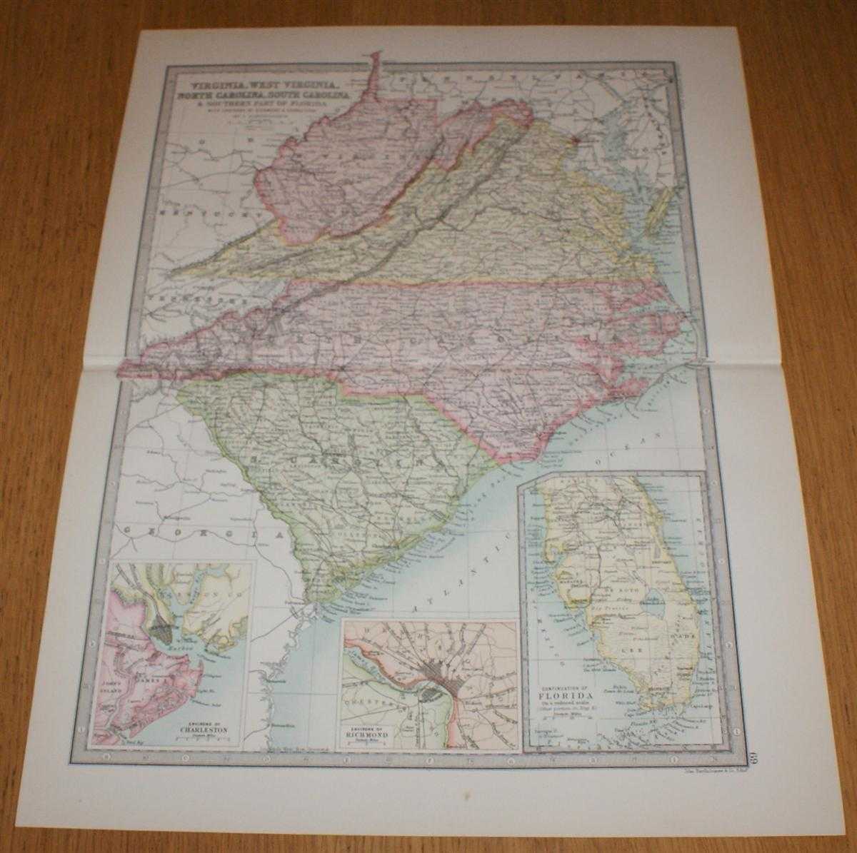
Title: Map of Virginia, West Virginia, North Carolina, South Carolina and the Southern part of Florida with inset plans showing Environs of Charleston and Richmond - Sheet 69, (part of USA), disbound from the 1890 'The Library Reference Atlas of the World'
Description: Macmillan and Co. London, 1890. First Edition, Softcover. Very Good Condition/No Dust Jacket. Single disbound coloured map sheet, from John Bartholomew's Library Reference Atlas, covering part of the United States of America. Suitable for framing. Approx size 46 x 35 cm, horizontal centre fold. Map is clean, crisp, clear and bright, occasional light foxing in margin. Sheet covers the part of USA including: Virginia, West Virginia, North Carolina, South Carolina and the Southern part of Florida, Wilmington, Charleston, Columbia, Raleigh, Richmond, Washington, Chesapeake Bay, Baltimore and Blue Ridge. Sheet contains three inset panels; a continuation of Florida, and two plans showing Environs of Charleston and Richmond. No dust jacket, as published. Quantity Available: 1. Shipped Weight: under 1 kg. Pictures of this item not already displayed here available upon request. Inventory No: 45020124066. ISBN: 0713486848
Keywords: BZDB4 Maps; Geology, geography, mineralogy, environment; World History; USA & Canada. John Bartholomew Map of Virginia, West Virginia, North Carolina, South Carolina and the Southern part of Florida with inset plans showing Environs of Charleston and Rich
See more books from our catalog: Maps
Title: Map of Virginia, West Virginia, North Carolina, South Carolina and the Southern part of Florida with inset plans showing Environs of Charleston and Richmond - Sheet 69, (part of USA), disbound from the 1890 'The Library Reference Atlas of the World'
Description: Macmillan and Co. London, 1890. First Edition, Softcover. Very Good Condition/No Dust Jacket. Single disbound coloured map sheet, from John Bartholomew's Library Reference Atlas, covering part of the United States of America. Suitable for framing. Approx size 46 x 35 cm, horizontal centre fold. Map is clean, crisp, clear and bright, occasional light foxing in margin. Sheet covers the part of USA including: Virginia, West Virginia, North Carolina, South Carolina and the Southern part of Florida, Wilmington, Charleston, Columbia, Raleigh, Richmond, Washington, Chesapeake Bay, Baltimore and Blue Ridge. Sheet contains three inset panels; a continuation of Florida, and two plans showing Environs of Charleston and Richmond. No dust jacket, as published. Quantity Available: 1. Shipped Weight: under 1 kg. Pictures of this item not already displayed here available upon request. Inventory No: 45020124066. ISBN: 0713486848
Keywords: BZDB4 Maps; Geology, geography, mineralogy, environment; World History; USA & Canada. John Bartholomew Map of Virginia, West Virginia, North Carolina, South Carolina and the Southern part of Florida with inset plans showing Environs of Charleston and Rich
Price: GBP 32.00 = appr. US$ 45.70 Seller: Bailgate Books Ltd
- Book number: 45020124066
- Book number: 45020124066
See more books from our catalog: Maps