Author: John Bartholomew
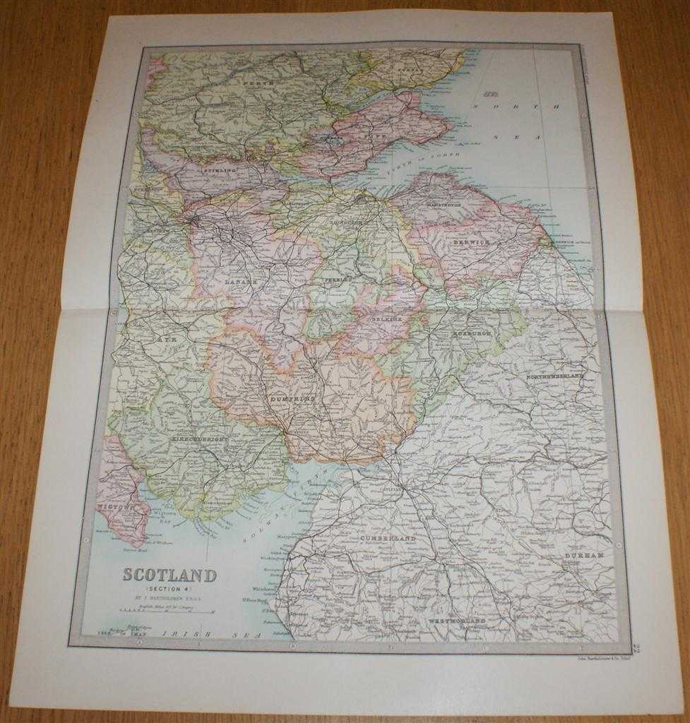
Title: Map of Scotland (Section 4) covering Southern Scotland and Scottish/English Border - Sheet 22 Disbound from the 1890 'The Library Reference Atlas of the World'
Description: Macmillan and Co. London, 1890. First Edition, Softcover. Very Good Condition/No Dust Jacket. Single disbound coloured map sheet from John Bartholomew's Library Reference Atlas. Section 4 only of 4 covering Scotland. Approx size 46 x 35 cm, horizontal centre fold. Corners lightly worn. Occasional light foxing in margin, map is otherwise clean, crisp, clear and bright. Sheet covers the southern Scotland and the Scottish Borders including: Stirling, Lanark, Glasgow, Edinburgh, Berwick, Fife, Kinross, Haddington, Peebles, Selkirk, Roxburgh, Dumfries, Kirkcudbright, Solway Firth, Firth of Forth, Firth of Tay, Dundee, Cumberland, Carlisle, and parts of Nothumberland, Durham, Westmorland, Perth and Forfar. No dust jacket, as published. Quantity Available: 1. Shipped Weight: under 1 kg. Pictures of this item not already displayed here available upon request. Inventory No: 45020124010. ISBN: 0297831518
Keywords: BZDB4 Maps; Durham, Northumberland and North east England ; Cumbria, Cumberland, Westmorland, Lake District; Scotland. John Bartholomew Map of Scotland (Section 4) covering Southern Scotland and Scottish/English Border - Sheet 22 Disbound from the 1890 'T
See more books from our catalog: Maps
Title: Map of Scotland (Section 4) covering Southern Scotland and Scottish/English Border - Sheet 22 Disbound from the 1890 'The Library Reference Atlas of the World'
Description: Macmillan and Co. London, 1890. First Edition, Softcover. Very Good Condition/No Dust Jacket. Single disbound coloured map sheet from John Bartholomew's Library Reference Atlas. Section 4 only of 4 covering Scotland. Approx size 46 x 35 cm, horizontal centre fold. Corners lightly worn. Occasional light foxing in margin, map is otherwise clean, crisp, clear and bright. Sheet covers the southern Scotland and the Scottish Borders including: Stirling, Lanark, Glasgow, Edinburgh, Berwick, Fife, Kinross, Haddington, Peebles, Selkirk, Roxburgh, Dumfries, Kirkcudbright, Solway Firth, Firth of Forth, Firth of Tay, Dundee, Cumberland, Carlisle, and parts of Nothumberland, Durham, Westmorland, Perth and Forfar. No dust jacket, as published. Quantity Available: 1. Shipped Weight: under 1 kg. Pictures of this item not already displayed here available upon request. Inventory No: 45020124010. ISBN: 0297831518
Keywords: BZDB4 Maps; Durham, Northumberland and North east England ; Cumbria, Cumberland, Westmorland, Lake District; Scotland. John Bartholomew Map of Scotland (Section 4) covering Southern Scotland and Scottish/English Border - Sheet 22 Disbound from the 1890 'T
Price: GBP 35.00 = appr. US$ 49.98 Seller: Bailgate Books Ltd
- Book number: 45020124010
- Book number: 45020124010
See more books from our catalog: Maps