Author: The Times and J. G. Bartholomew
Title: Map of South Africa from 1920 Times Atlas on two sheets (Plates 72 and 73) including Cape Province, Orange Free State, Transvaal, British Bechuanaland, Basutoland (Lesotho) and Swaziland (Eswatini)
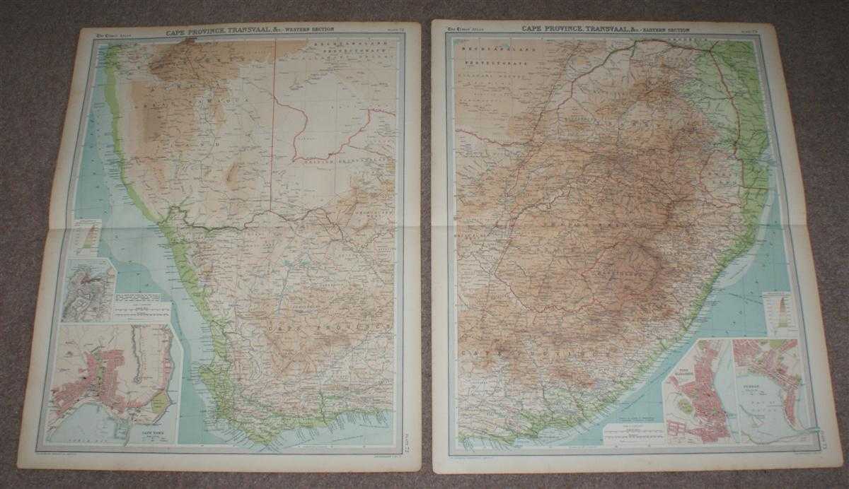
Description: The Times, London, 1920. First Edition, Softcover. Very Good Condition/No Dust Jacket. Two disbound map sheets with horizontal centre folds from the 1920 "The Times Survey Atlas of the World". Maps are in colour and suitable for framing. Colour is according to contour, boundaries of countries and regions/states are in red. Map at scale 1:2,500,000. The whole of modern day South Africa is covered over the two sheets, included are inset plans of Table Mountain, Cape Town, Port Elizabeth and Durban at closer scale. Map covers Cape Province, Orange Free State, Transvaal, British Bechuanaland, Basutoland (Lesotho) and Swaziland (Eswatini) with parts of Great Namaqua (Namimbia), Bechuanaland Protectorate (Botswana) and Portuguese East Africa (Mozambique). Slightly darkened edges with foxing in margins, sheets are otherwise, bright, clean and crisp. Size: Two sheets both 58cm x 46cm approx. Quantity Available: 1. Shipped Weight: under 1 kg. Pictures of this item not already displayed here available upon request. Inventory No: 45020044045. ISBN: 0586044434
Keywords: BZDB4 Maps; World History; British History; Africa. The Times and J. G. Bartholomew Map of South Africa from 1920 Times Atlas on two sheets (Plates 72 and 73) including Cape Province, Orange Free State, Transvaal, British Bechuanaland, Basutoland (Lesotho
See more books from our catalog: Maps
Title: Map of South Africa from 1920 Times Atlas on two sheets (Plates 72 and 73) including Cape Province, Orange Free State, Transvaal, British Bechuanaland, Basutoland (Lesotho) and Swaziland (Eswatini)
Description: The Times, London, 1920. First Edition, Softcover. Very Good Condition/No Dust Jacket. Two disbound map sheets with horizontal centre folds from the 1920 "The Times Survey Atlas of the World". Maps are in colour and suitable for framing. Colour is according to contour, boundaries of countries and regions/states are in red. Map at scale 1:2,500,000. The whole of modern day South Africa is covered over the two sheets, included are inset plans of Table Mountain, Cape Town, Port Elizabeth and Durban at closer scale. Map covers Cape Province, Orange Free State, Transvaal, British Bechuanaland, Basutoland (Lesotho) and Swaziland (Eswatini) with parts of Great Namaqua (Namimbia), Bechuanaland Protectorate (Botswana) and Portuguese East Africa (Mozambique). Slightly darkened edges with foxing in margins, sheets are otherwise, bright, clean and crisp. Size: Two sheets both 58cm x 46cm approx. Quantity Available: 1. Shipped Weight: under 1 kg. Pictures of this item not already displayed here available upon request. Inventory No: 45020044045. ISBN: 0586044434
Keywords: BZDB4 Maps; World History; British History; Africa. The Times and J. G. Bartholomew Map of South Africa from 1920 Times Atlas on two sheets (Plates 72 and 73) including Cape Province, Orange Free State, Transvaal, British Bechuanaland, Basutoland (Lesotho
Price: GBP 38.00 = appr. US$ 54.26 Seller: Bailgate Books Ltd
- Book number: 45020044045
- Book number: 45020044045
See more books from our catalog: Maps