Author: The Times and J. G. Bartholomew
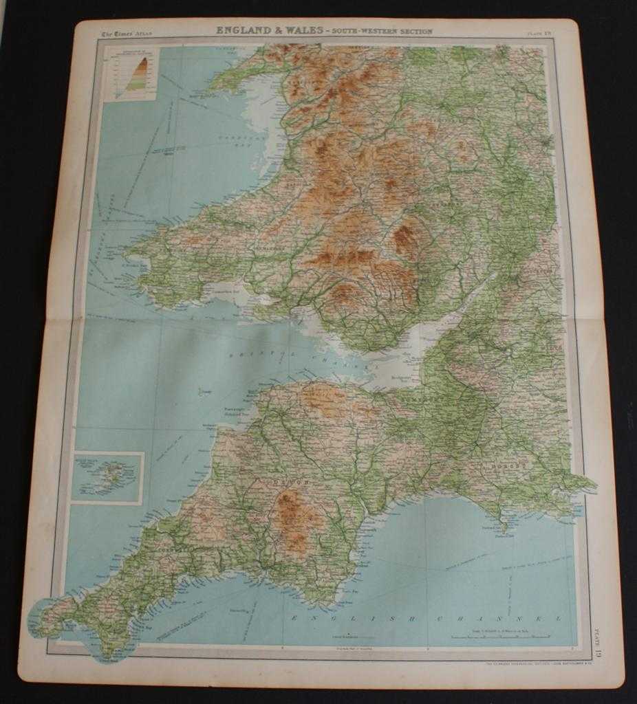
Title: Map of South West England and South Wales from the 1920 Times Atlas (Plate 19 "England & Wales - South-Western Section") covering Cornwall, Devon, Somerset, Dorset, Glamorgan, Monmouth, Merioneth, Shropshire, etc.
Description: The Times, London, 1920. First Edition, Softcover. Very Good Condition/No Dust Jacket. Disbound single sheet with horizontal centre fold from the 1920 "The Times Survey Atlas of the World". Map is in colour and is suitable for framing. Colour on both land and sea according to contour. Map at scale 1:633,600 with the Scilly Isles included in an inset continuation panel. Map covers Cornwall, Devon, Somerset, Dorset, Glamorgan, Monmouth, Merioneth, Montgomery, Hereford, Worcester, Birmingham, Bristol, Gloucester, Carmarthen, Pembroke, Cardigan, Brecknock, Stafford, Shropshire, Cardigan Bay, Bristol Channel, Lundy, Scilly Isles, Dartmoor, Exmoor, etc. etc. Slightly darkened and worn edges with occasional light foxing in the margins. Sheet is otherwise crisp and clean. Size: 58cm x 46cm approx. Quantity Available: 1. Shipped Weight: under 1 kg. Pictures of this item not already displayed here available upon request. Inventory No: 45020044024. ISBN: 0586044434
Keywords: BZDB4 Maps; Wales and Welsh History, literature & language; British History; West Country - Cornwall, Devon, Somerset & Dorset. The Times and J. G. Bartholomew Map of South West England and South Wales from the 1920 Times Atlas (Plate 19 "England & Wales
See more books from our catalog: Maps
Title: Map of South West England and South Wales from the 1920 Times Atlas (Plate 19 "England & Wales - South-Western Section") covering Cornwall, Devon, Somerset, Dorset, Glamorgan, Monmouth, Merioneth, Shropshire, etc.
Description: The Times, London, 1920. First Edition, Softcover. Very Good Condition/No Dust Jacket. Disbound single sheet with horizontal centre fold from the 1920 "The Times Survey Atlas of the World". Map is in colour and is suitable for framing. Colour on both land and sea according to contour. Map at scale 1:633,600 with the Scilly Isles included in an inset continuation panel. Map covers Cornwall, Devon, Somerset, Dorset, Glamorgan, Monmouth, Merioneth, Montgomery, Hereford, Worcester, Birmingham, Bristol, Gloucester, Carmarthen, Pembroke, Cardigan, Brecknock, Stafford, Shropshire, Cardigan Bay, Bristol Channel, Lundy, Scilly Isles, Dartmoor, Exmoor, etc. etc. Slightly darkened and worn edges with occasional light foxing in the margins. Sheet is otherwise crisp and clean. Size: 58cm x 46cm approx. Quantity Available: 1. Shipped Weight: under 1 kg. Pictures of this item not already displayed here available upon request. Inventory No: 45020044024. ISBN: 0586044434
Keywords: BZDB4 Maps; Wales and Welsh History, literature & language; British History; West Country - Cornwall, Devon, Somerset & Dorset. The Times and J. G. Bartholomew Map of South West England and South Wales from the 1920 Times Atlas (Plate 19 "England & Wales
Price: GBP 22.00 = appr. US$ 31.42 Seller: Bailgate Books Ltd
- Book number: 45020044024
- Book number: 45020044024
See more books from our catalog: Maps