Author: The Times and J. G. Bartholomew
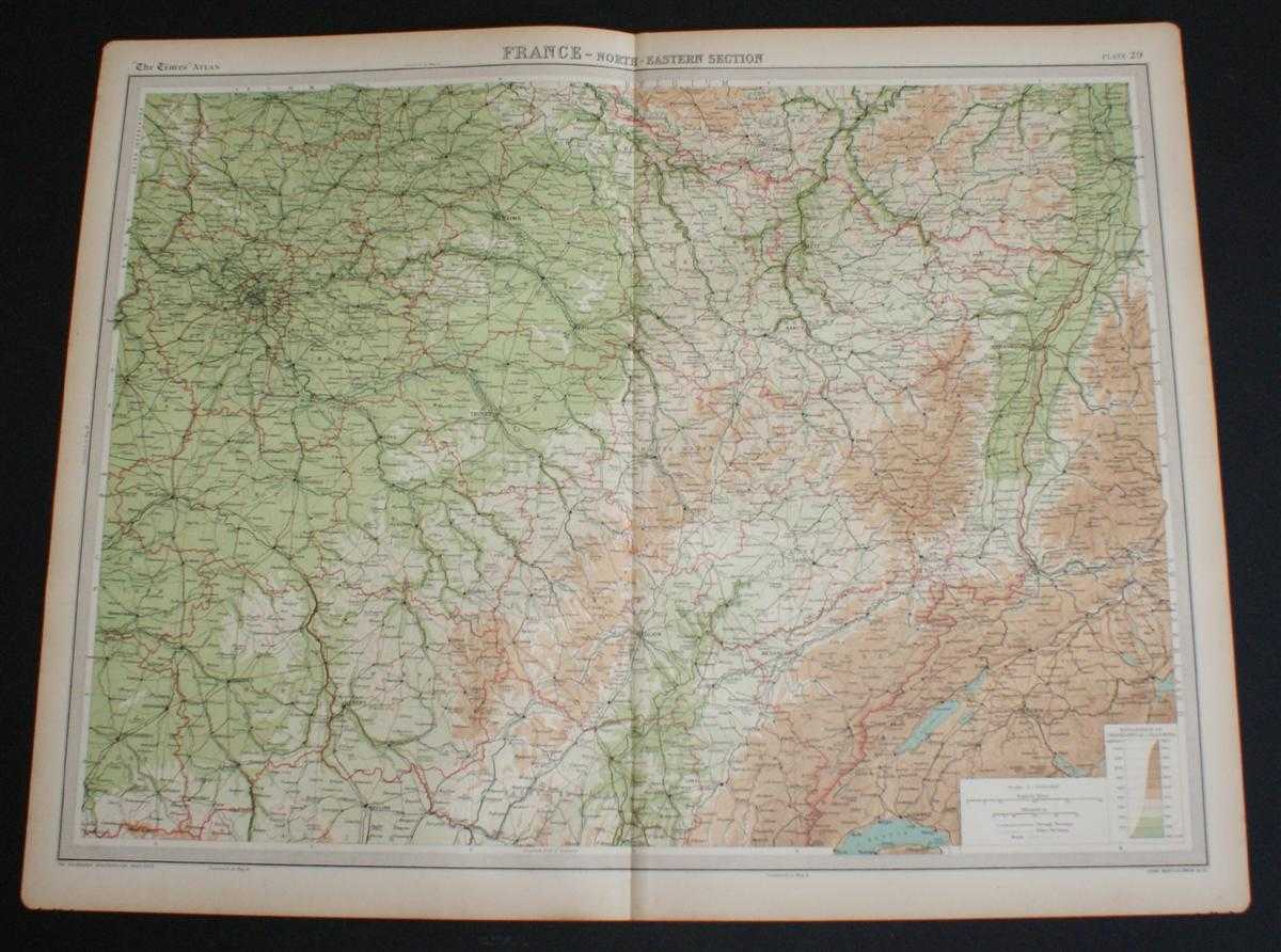
Title: Map of "France - North-Eastern Section" from 1920 Times Atlas (Plate 29) covering Paris, Orleans, Moulins, Nevers, Troyes, Riems, Nancy, Dijon, Strasbourg, Mulhouse, Besancon, Luxemburg, Mannheim, Basel and Bern
Description: The Times, London, 1920. First Edition, Softcover. Very Good Condition/No Dust Jacket. Disbound single sheet with vertical centre fold from the 1920 "The Times Survey Atlas of the World". Map is in colour and suitable for framing. Colour is according to contour, boundaries of departments and countries are in red. Map at scale 1:1,000,000. Map covers the north eastern departments of France and parts of Belgium, Germany and Switzerland and includes Paris, Orleans, Moulins, Nevers, Troyes, Riems, Nancy, Metz, Dijon, Strasbourg, Mulhouse, Besancon, Luxemburg, Mannheim, Basel, Bern, etc. Slightly darkened edges with occasional very light foxing in the margins. Bottom edges at corners are slightly roughened. Sheet is otherwise crisp, clean and bright. Size: 46cm x 58cm approx. Quantity Available: 1. Shipped Weight: under 1 kg. Pictures of this item not already displayed here available upon request. Inventory No: 45020044007. ISBN: 0586044434
Keywords: BZDB4 Maps; Germany, Austria, Switzerland and German Language; European History; France and French Language. The Times and J. G. Bartholomew Map of "France - North-Eastern Section" from 1920 Times Atlas (Plate 29) covering Paris, Orleans, Moulins, Nevers,
See more books from our catalog: Maps
Title: Map of "France - North-Eastern Section" from 1920 Times Atlas (Plate 29) covering Paris, Orleans, Moulins, Nevers, Troyes, Riems, Nancy, Dijon, Strasbourg, Mulhouse, Besancon, Luxemburg, Mannheim, Basel and Bern
Description: The Times, London, 1920. First Edition, Softcover. Very Good Condition/No Dust Jacket. Disbound single sheet with vertical centre fold from the 1920 "The Times Survey Atlas of the World". Map is in colour and suitable for framing. Colour is according to contour, boundaries of departments and countries are in red. Map at scale 1:1,000,000. Map covers the north eastern departments of France and parts of Belgium, Germany and Switzerland and includes Paris, Orleans, Moulins, Nevers, Troyes, Riems, Nancy, Metz, Dijon, Strasbourg, Mulhouse, Besancon, Luxemburg, Mannheim, Basel, Bern, etc. Slightly darkened edges with occasional very light foxing in the margins. Bottom edges at corners are slightly roughened. Sheet is otherwise crisp, clean and bright. Size: 46cm x 58cm approx. Quantity Available: 1. Shipped Weight: under 1 kg. Pictures of this item not already displayed here available upon request. Inventory No: 45020044007. ISBN: 0586044434
Keywords: BZDB4 Maps; Germany, Austria, Switzerland and German Language; European History; France and French Language. The Times and J. G. Bartholomew Map of "France - North-Eastern Section" from 1920 Times Atlas (Plate 29) covering Paris, Orleans, Moulins, Nevers,
Price: GBP 22.00 = appr. US$ 31.42 Seller: Bailgate Books Ltd
- Book number: 45020044007
- Book number: 45020044007
See more books from our catalog: Maps