Author: The Times and J. G. Bartholomew
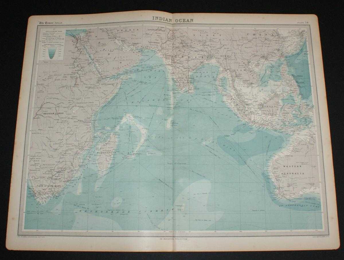
Title: Map of the Indian Ocean from the 1920 Times Survey Atlas (Plate 54) including currents and shipping routes
Description: Map The Times, London, 1920. First Edition, Softcover. Very Good Condition/No Dust Jacket. Disbound single sheet with vertical centre fold from the 1920 "The Times Survey Atlas of the World". Map is in colour and suitable for framing, land is grey and seas are shades of blue according to depth. Map covers whole of Indian Ocean and includes current arrows and shipping and trade routes. Map includes Belgian Congo, Sudan, Egypt, Madagascar, Cape of Good Hope, Arabia, Red Sea, Baluchistan, India, Burma, Siam, Sumatra, Borneo, Philippines, Western Australia, Mocambique Current, Drift of the SE Trade Wind, Malabar Current, Arabian Bay, Bay of Bengal, South China Sea, Retrgrade Current, etc. Slightly darkened edges with occasional light foxing in margins, sheet is otherwise clean and crisp. Item Type: Map. Single sheet map/chart which is suitable for framing and will be shipped rolled and in a cardboard tube. Quantity Available: 1. Shipped Weight: under 1 kg. Pictures of this item not already displayed here available upon request. Inventory No: 45020034045. ISBN: 0850335086
Keywords: BZDB4 Maps; Indian sub-continent & South East Asia; Africa; naval, naval history, maritime, ships, boats. The Times and J. G. Bartholomew Map of the Indian Ocean from the 1920 Times Survey Atlas (Plate 54) including currents and shipping routes Indian sub
See more books from our catalog: Maps
Title: Map of the Indian Ocean from the 1920 Times Survey Atlas (Plate 54) including currents and shipping routes
Description: Map The Times, London, 1920. First Edition, Softcover. Very Good Condition/No Dust Jacket. Disbound single sheet with vertical centre fold from the 1920 "The Times Survey Atlas of the World". Map is in colour and suitable for framing, land is grey and seas are shades of blue according to depth. Map covers whole of Indian Ocean and includes current arrows and shipping and trade routes. Map includes Belgian Congo, Sudan, Egypt, Madagascar, Cape of Good Hope, Arabia, Red Sea, Baluchistan, India, Burma, Siam, Sumatra, Borneo, Philippines, Western Australia, Mocambique Current, Drift of the SE Trade Wind, Malabar Current, Arabian Bay, Bay of Bengal, South China Sea, Retrgrade Current, etc. Slightly darkened edges with occasional light foxing in margins, sheet is otherwise clean and crisp. Item Type: Map. Single sheet map/chart which is suitable for framing and will be shipped rolled and in a cardboard tube. Quantity Available: 1. Shipped Weight: under 1 kg. Pictures of this item not already displayed here available upon request. Inventory No: 45020034045. ISBN: 0850335086
Keywords: BZDB4 Maps; Indian sub-continent & South East Asia; Africa; naval, naval history, maritime, ships, boats. The Times and J. G. Bartholomew Map of the Indian Ocean from the 1920 Times Survey Atlas (Plate 54) including currents and shipping routes Indian sub
Price: GBP 26.00 = appr. US$ 37.13 Seller: Bailgate Books Ltd
- Book number: 45020034045
- Book number: 45020034045
See more books from our catalog: Maps