Author: The Times and J. G. Bartholomew
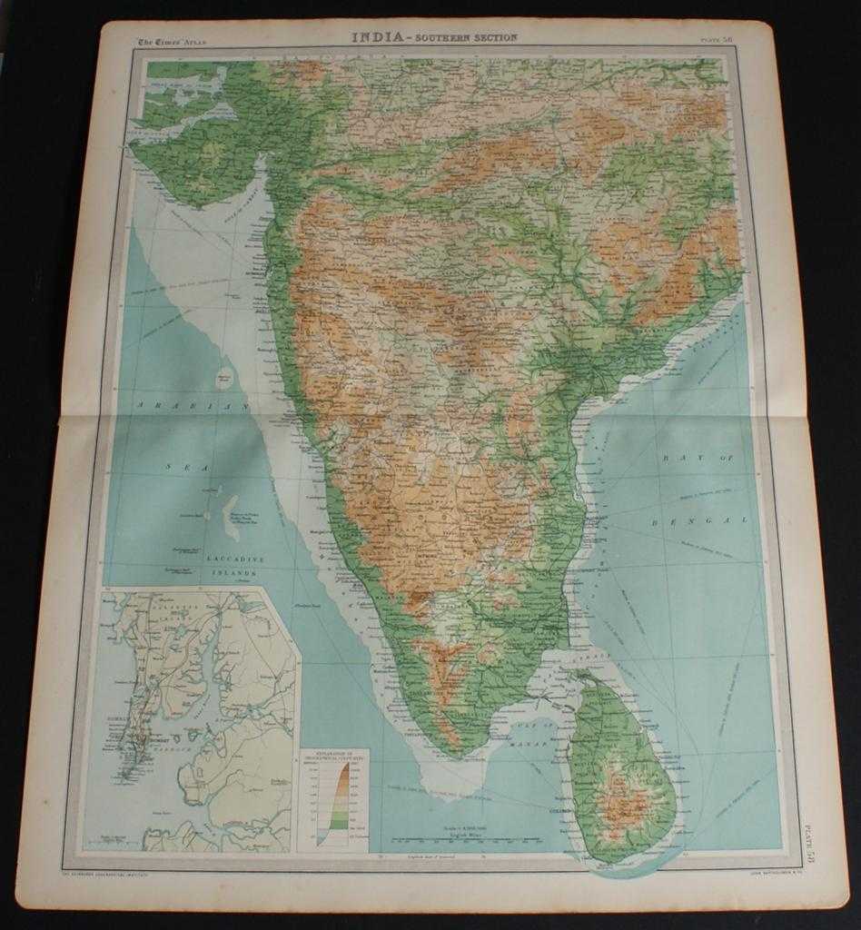
Title: Map of "India - Southern Section" from the 1920 Times Survey Atlas (Plate 58) covering Mysore, Hyrerabad, Central Provinces, Ceylon (Sri Lanka), Kathainwar, Bombay, Baroda, Chota, Laccadive Islands, etc.
Description: Map The Times, London, 1920. First Edition, Softcover. Very Good Condition/No Dust Jacket. Disbound single sheet with horizontal centre fold from the 1920 "The Times Survey Atlas of the World". Map is in colour and suitable for framing. Colour on both land and sea according to contour. Map at scale 1:4,000,000 with small inset map of Bombay at scale 1:340,000. Map covers; India (part), Mysore, Hyrerabad, Central Provinces, Ceylon (Sri Lanka), Colombo, Kathainwar, Bombay, Baroda, Chota, Coromandel Coast, Laccadive Islands, Bay of Bengal (part), Gulf of Cambay, Gulf of Manar, Arabian Sea (part), etc. Slightly darkened edges with occasional light foxing or staining in margins but sheet is otherwise clean and crisp. Item Type: Map. Single sheet map/chart which is suitable for framing and will be shipped rolled and in a cardboard tube. Quantity Available: 1. Shipped Weight: under 1 kg. Pictures of this item not already displayed here available upon request. Inventory No: 45020034035. ISBN: 0850335086
Keywords: BZDB4 Maps; World History; naval, naval history, maritime, ships, boats; Indian sub-continent & South East Asia. The Times and J. G. Bartholomew Map of "India - Southern Section" from the 1920 Times Survey Atlas (Plate 58) covering Mysore, Hyrerabad, Cent
See more books from our catalog: Maps
Title: Map of "India - Southern Section" from the 1920 Times Survey Atlas (Plate 58) covering Mysore, Hyrerabad, Central Provinces, Ceylon (Sri Lanka), Kathainwar, Bombay, Baroda, Chota, Laccadive Islands, etc.
Description: Map The Times, London, 1920. First Edition, Softcover. Very Good Condition/No Dust Jacket. Disbound single sheet with horizontal centre fold from the 1920 "The Times Survey Atlas of the World". Map is in colour and suitable for framing. Colour on both land and sea according to contour. Map at scale 1:4,000,000 with small inset map of Bombay at scale 1:340,000. Map covers; India (part), Mysore, Hyrerabad, Central Provinces, Ceylon (Sri Lanka), Colombo, Kathainwar, Bombay, Baroda, Chota, Coromandel Coast, Laccadive Islands, Bay of Bengal (part), Gulf of Cambay, Gulf of Manar, Arabian Sea (part), etc. Slightly darkened edges with occasional light foxing or staining in margins but sheet is otherwise clean and crisp. Item Type: Map. Single sheet map/chart which is suitable for framing and will be shipped rolled and in a cardboard tube. Quantity Available: 1. Shipped Weight: under 1 kg. Pictures of this item not already displayed here available upon request. Inventory No: 45020034035. ISBN: 0850335086
Keywords: BZDB4 Maps; World History; naval, naval history, maritime, ships, boats; Indian sub-continent & South East Asia. The Times and J. G. Bartholomew Map of "India - Southern Section" from the 1920 Times Survey Atlas (Plate 58) covering Mysore, Hyrerabad, Cent
Price: GBP 20.00 = appr. US$ 28.56 Seller: Bailgate Books Ltd
- Book number: 45020034035
- Book number: 45020034035
See more books from our catalog: Maps