Author: The Times and J. G. Bartholomew
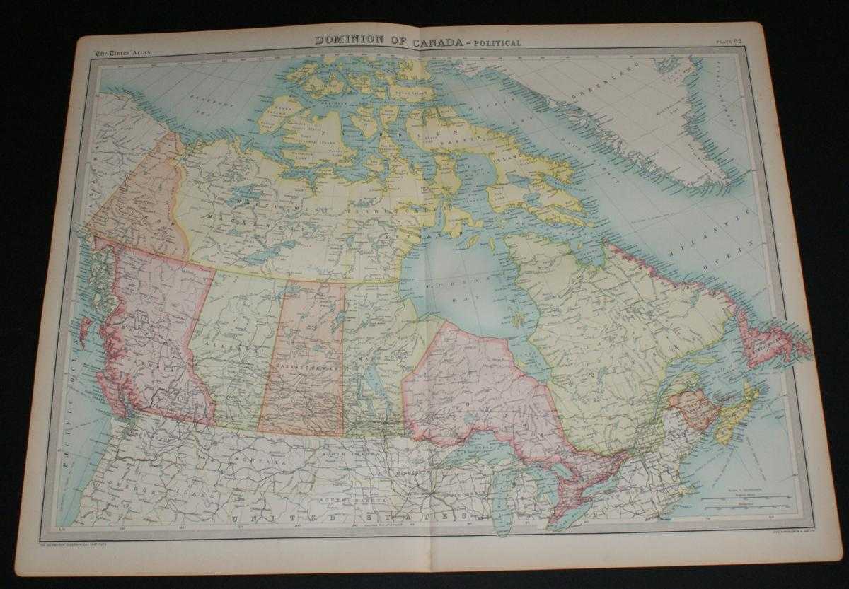
Title: Map of Canada from the 1920 Times Survey Atlas (Plate 82 Dominion of Canada - Political)
Description: Map The Times, London, 1920. First Edition, Softcover. Very Good Condition/No Dust Jacket. Disbound single sheet with vertical centre fold from the 1920 "The Times Survey Atlas of the World". Map is in colour and suitable for framing. Coloured according to province. Map at scale 1:10,000,000. Map covers; Yukon, North West Territories, Mackenzie, Keewatin, Franklin, British Columbia, Alberta, Saskatchewan, Manitoba, Ontario, Quebec, New Brunswick, Nova Scotia, Newfoundland, Labrador, US Border and some northern States, parts of Greenland and Alaska, Beaufort Sea, Davis Strait, Hudson Bay, etc. Slightly darkened edges with occasional light foxing in margins but sheet is otherwise clean and crisp. Item Type: Map. Single sheet map/chart which is suitable for framing and will be shipped rolled and in a cardboard tube. Quantity Available: 1. Shipped Weight: under 1 kg. Pictures of this item not already displayed here available upon request. Inventory No: 45020034025. ISBN: 0850335086
Keywords: BZDB4 Maps; South & Central America & the West Indies; World History; USA & Canada. The Times and J. G. Bartholomew Map of Canada from the 1920 Times Survey Atlas (Plate 82 Dominion of Canada - Political) South & Central America & the West Indies World Hi
See more books from our catalog: Maps
Title: Map of Canada from the 1920 Times Survey Atlas (Plate 82 Dominion of Canada - Political)
Description: Map The Times, London, 1920. First Edition, Softcover. Very Good Condition/No Dust Jacket. Disbound single sheet with vertical centre fold from the 1920 "The Times Survey Atlas of the World". Map is in colour and suitable for framing. Coloured according to province. Map at scale 1:10,000,000. Map covers; Yukon, North West Territories, Mackenzie, Keewatin, Franklin, British Columbia, Alberta, Saskatchewan, Manitoba, Ontario, Quebec, New Brunswick, Nova Scotia, Newfoundland, Labrador, US Border and some northern States, parts of Greenland and Alaska, Beaufort Sea, Davis Strait, Hudson Bay, etc. Slightly darkened edges with occasional light foxing in margins but sheet is otherwise clean and crisp. Item Type: Map. Single sheet map/chart which is suitable for framing and will be shipped rolled and in a cardboard tube. Quantity Available: 1. Shipped Weight: under 1 kg. Pictures of this item not already displayed here available upon request. Inventory No: 45020034025. ISBN: 0850335086
Keywords: BZDB4 Maps; South & Central America & the West Indies; World History; USA & Canada. The Times and J. G. Bartholomew Map of Canada from the 1920 Times Survey Atlas (Plate 82 Dominion of Canada - Political) South & Central America & the West Indies World Hi
Price: GBP 28.00 = appr. US$ 39.98 Seller: Bailgate Books Ltd
- Book number: 45020034025
- Book number: 45020034025
See more books from our catalog: Maps