Author: The Times and J. G. Bartholomew
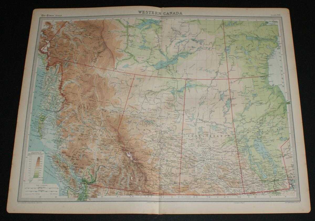
Title: Map of Western Canada from the 1920 Times Survey Atlas (Plate 84) including British Columbia, Alberta, Saskatchewan, Manitoba and parts of Yukon, Mackenzie and Keewatin
Description: Map The Times, London, 1920. First Edition, Softcover. Very Good Condition/No Dust Jacket. Disbound single sheet with vertical centre fold from the 1920 "The Times Survey Atlas of the World". Map is in colour and suitable for framing. Colour on both land and sea according to contour. Map at scale 1:5,000,000. Map covers; British Columbia, Alberta, Saskatchewan, Manitoba and parts of Yukon, Mackenzie (Northwest Territories), Keewatin (Nunavut) and Alaska, Lake Winnipeg, Great Slave Lake, Great Bear Lake (part), Vancouver, Calgary, Edmunton, etc. Slightly darkened edges with occasional foxing in margins but sheet is otherwise clean and crisp. Item Type: Map. Single sheet map/chart which is suitable for framing and will be shipped rolled and in a cardboard tube. Quantity Available: 1. Shipped Weight: under 1 kg. Pictures of this item not already displayed here available upon request. Inventory No: 45020034023. ISBN: 0850335086
Keywords: BZDB4 Maps; World History; USA & Canada. The Times and J. G. Bartholomew Map of Western Canada from the 1920 Times Survey Atlas (Plate 84) including British Columbia, Alberta, Saskatchewan, Manitoba and parts of Yukon, Mackenzie and Keewatin World History
See more books from our catalog: Maps
Title: Map of Western Canada from the 1920 Times Survey Atlas (Plate 84) including British Columbia, Alberta, Saskatchewan, Manitoba and parts of Yukon, Mackenzie and Keewatin
Description: Map The Times, London, 1920. First Edition, Softcover. Very Good Condition/No Dust Jacket. Disbound single sheet with vertical centre fold from the 1920 "The Times Survey Atlas of the World". Map is in colour and suitable for framing. Colour on both land and sea according to contour. Map at scale 1:5,000,000. Map covers; British Columbia, Alberta, Saskatchewan, Manitoba and parts of Yukon, Mackenzie (Northwest Territories), Keewatin (Nunavut) and Alaska, Lake Winnipeg, Great Slave Lake, Great Bear Lake (part), Vancouver, Calgary, Edmunton, etc. Slightly darkened edges with occasional foxing in margins but sheet is otherwise clean and crisp. Item Type: Map. Single sheet map/chart which is suitable for framing and will be shipped rolled and in a cardboard tube. Quantity Available: 1. Shipped Weight: under 1 kg. Pictures of this item not already displayed here available upon request. Inventory No: 45020034023. ISBN: 0850335086
Keywords: BZDB4 Maps; World History; USA & Canada. The Times and J. G. Bartholomew Map of Western Canada from the 1920 Times Survey Atlas (Plate 84) including British Columbia, Alberta, Saskatchewan, Manitoba and parts of Yukon, Mackenzie and Keewatin World History
Price: GBP 26.00 = appr. US$ 37.13 Seller: Bailgate Books Ltd
- Book number: 45020034023
- Book number: 45020034023
See more books from our catalog: Maps