Author: The Times and J. G. Bartholomew
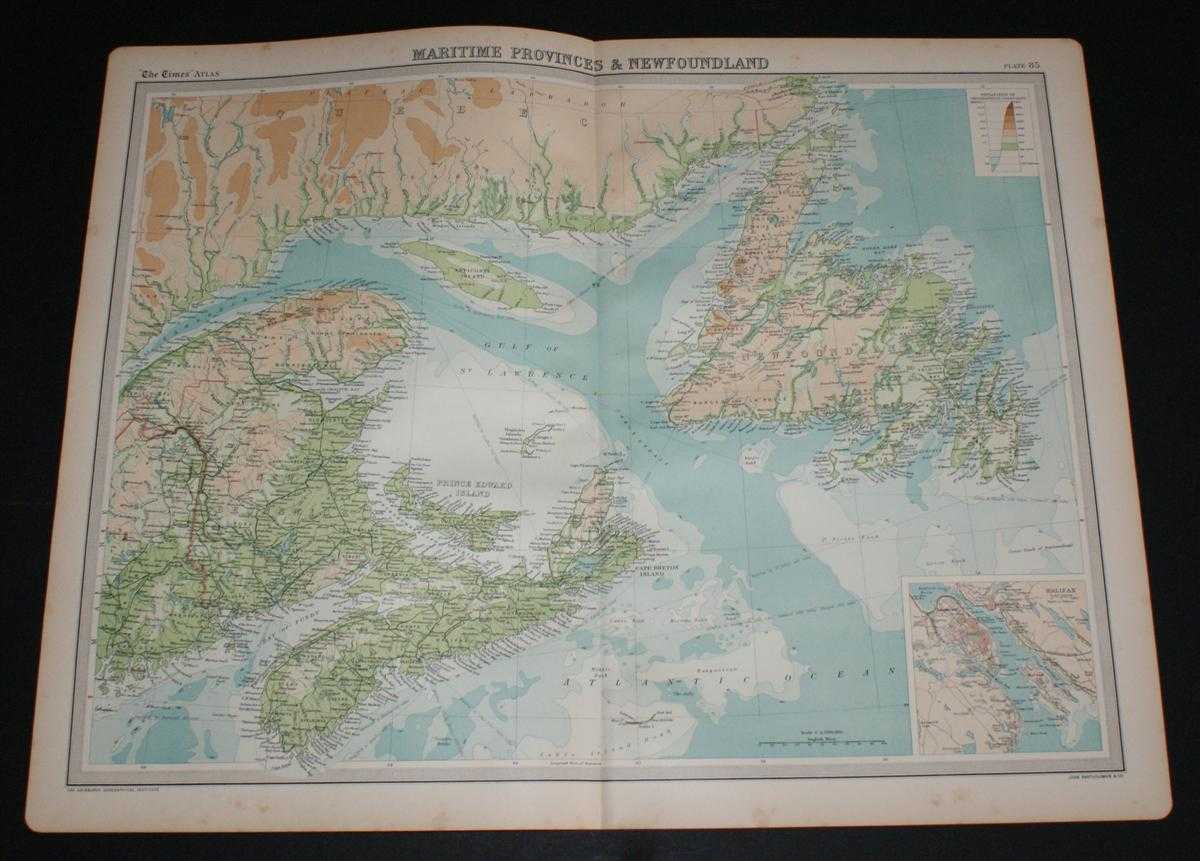
Title: Map of Maritime Provinces and Newfoundland, Canada from the 1920 Times Survey Atlas (Plate 85) including Prince Edward Island, Anticost Island, New Brunswick, Nova Scotia, Cape Breton Island and the Gulf of St. Lawrence
Description: Map The Times, London, 1920. First Edition, Softcover. Very Good Condition/No Dust Jacket. Disbound single sheet with vertical centre fold from the 1920 "The Times Survey Atlas of the World". Map is in colour and suitable for framing. Colour on both land and sea according to contour. Map at scale 1:2,500,000. Map covers; Newfoundland, New Brunswick, Quebec (part), Maine (part), Nova Scotia, Prince Edward Island, Cape Breton Island, Anticosti Island, Gulf of St. Lawrence, Magdalen Island, Bay of Fundy, Northumberland Strait, etc. Sheet contains inset plan of Halifax at scale 1:150,000. Slightly darkened edges with occasional light foxing in margins but sheet is otherwise clean and crisp. Item Type: Map. Single sheet map/chart which is suitable for framing and will be shipped rolled and in a cardboard tube. Quantity Available: 1. Shipped Weight: under 1 kg. Pictures of this item not already displayed here available upon request. Inventory No: 45020034022. ISBN: 0850335086
Keywords: BZDB4 Maps; World History; USA & Canada. The Times and J. G. Bartholomew Map of Maritime Provinces and Newfoundland, Canada from the 1920 Times Survey Atlas (Plate 85) including Prince Edward Island, Anticost Island, New Brunswick, Nova Scotia, Cape Breto
See more books from our catalog: Maps
Title: Map of Maritime Provinces and Newfoundland, Canada from the 1920 Times Survey Atlas (Plate 85) including Prince Edward Island, Anticost Island, New Brunswick, Nova Scotia, Cape Breton Island and the Gulf of St. Lawrence
Description: Map The Times, London, 1920. First Edition, Softcover. Very Good Condition/No Dust Jacket. Disbound single sheet with vertical centre fold from the 1920 "The Times Survey Atlas of the World". Map is in colour and suitable for framing. Colour on both land and sea according to contour. Map at scale 1:2,500,000. Map covers; Newfoundland, New Brunswick, Quebec (part), Maine (part), Nova Scotia, Prince Edward Island, Cape Breton Island, Anticosti Island, Gulf of St. Lawrence, Magdalen Island, Bay of Fundy, Northumberland Strait, etc. Sheet contains inset plan of Halifax at scale 1:150,000. Slightly darkened edges with occasional light foxing in margins but sheet is otherwise clean and crisp. Item Type: Map. Single sheet map/chart which is suitable for framing and will be shipped rolled and in a cardboard tube. Quantity Available: 1. Shipped Weight: under 1 kg. Pictures of this item not already displayed here available upon request. Inventory No: 45020034022. ISBN: 0850335086
Keywords: BZDB4 Maps; World History; USA & Canada. The Times and J. G. Bartholomew Map of Maritime Provinces and Newfoundland, Canada from the 1920 Times Survey Atlas (Plate 85) including Prince Edward Island, Anticost Island, New Brunswick, Nova Scotia, Cape Breto
Price: GBP 22.00 = appr. US$ 31.42 Seller: Bailgate Books Ltd
- Book number: 45020034022
- Book number: 45020034022
See more books from our catalog: Maps