Author: The Times and J. G. Bartholomew
Title: Map of Manitoba and North-West Ontario, Canada from the 1920 Times Survey Atlas (Plate 87)
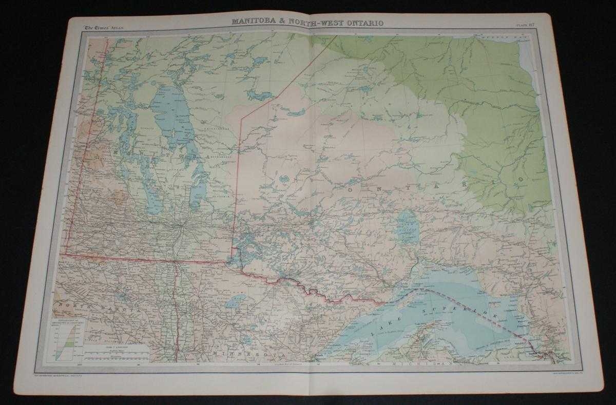
Description: Map The Times, London, 1920. First Edition, Softcover. Very Good Condition/No Dust Jacket. Disbound single sheet with vertical centre fold from the 1920 "The Times Survey Atlas of the World". Map is in colour and suitable for framing. Colour according to contour. Map at scale 1:2,500,000. Map covers; Manitora (as far north as Clearwater Lake only), Ontario (part), North Dakota (part), Minnesota (part), Lake Winnipeg, Lake Superior, Lake Nipigon, Brandon, Winnipeg, Fort William, Sault Ste Marie, Albany River, Duluth, etc. Slightly darkened edges with very occasional light foxing in margins but sheet is otherwise clean and crisp. Item Type: Map. Single sheet map/chart which is suitable for framing and will be shipped rolled and in a cardboard tube. Quantity Available: 1. Shipped Weight: under 1 kg. Pictures of this item not already displayed here available upon request. Inventory No: 45020034020. ISBN: 0850335086
Keywords: BZDB4 Maps; World History; USA & Canada. The Times and J. G. Bartholomew Map of Manitoba and North-West Ontario, Canada from the 1920 Times Survey Atlas (Plate 87) World History USA & Canada
See more books from our catalog: Maps
Title: Map of Manitoba and North-West Ontario, Canada from the 1920 Times Survey Atlas (Plate 87)
Description: Map The Times, London, 1920. First Edition, Softcover. Very Good Condition/No Dust Jacket. Disbound single sheet with vertical centre fold from the 1920 "The Times Survey Atlas of the World". Map is in colour and suitable for framing. Colour according to contour. Map at scale 1:2,500,000. Map covers; Manitora (as far north as Clearwater Lake only), Ontario (part), North Dakota (part), Minnesota (part), Lake Winnipeg, Lake Superior, Lake Nipigon, Brandon, Winnipeg, Fort William, Sault Ste Marie, Albany River, Duluth, etc. Slightly darkened edges with very occasional light foxing in margins but sheet is otherwise clean and crisp. Item Type: Map. Single sheet map/chart which is suitable for framing and will be shipped rolled and in a cardboard tube. Quantity Available: 1. Shipped Weight: under 1 kg. Pictures of this item not already displayed here available upon request. Inventory No: 45020034020. ISBN: 0850335086
Keywords: BZDB4 Maps; World History; USA & Canada. The Times and J. G. Bartholomew Map of Manitoba and North-West Ontario, Canada from the 1920 Times Survey Atlas (Plate 87) World History USA & Canada
Price: GBP 20.00 = appr. US$ 28.56 Seller: Bailgate Books Ltd
- Book number: 45020034020
- Book number: 45020034020
See more books from our catalog: Maps