Author: The Times and J. G. Bartholomew
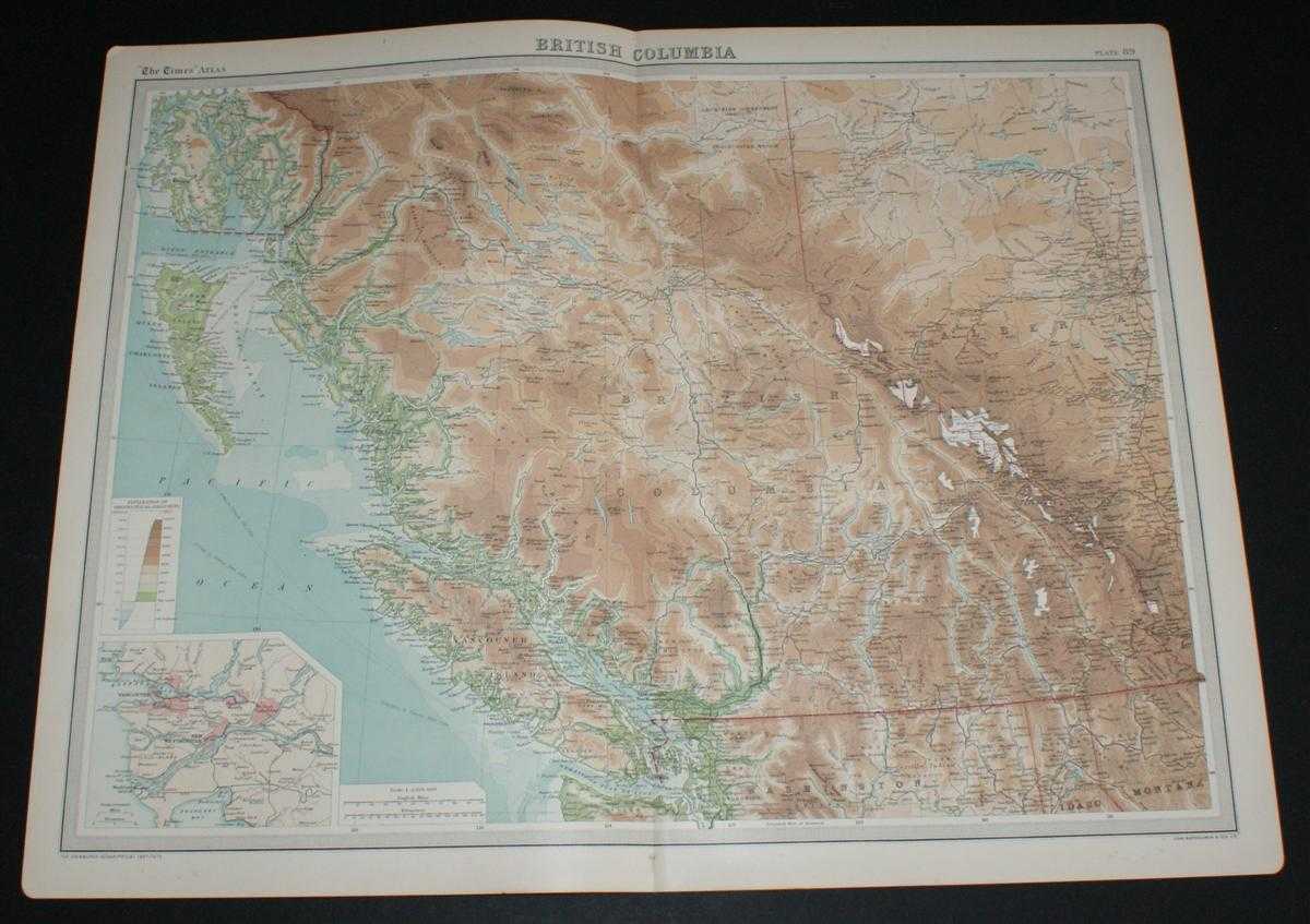
Title: Map of British Columbia, Canada from the 1920 Times Survey Atlas (Plate 89) including part of Alberta, Vancouver Island, Queen Charlotte Islands and Prince of Wales Island etc.
Description: Map The Times, London, 1920. First Edition, Softcover. Very Good Condition/No Dust Jacket. Disbound single sheet with vertical centre fold from the 1920 "The Times Survey Atlas of the World". Map is in colour and suitable for framing. Colour on both land and sea according to contour. Map at scale 1:2,500,000. Map covers; British Columbia (as far North as Zarembo Island), Alberta (part), Rocky Mountains, Vancouver Island, US Border, Washington (part), Idaho (part), Montana (part), Calgary, Edmonton, Lesser Slave Lake, Graham Island, Hecate Strait, Strait of Juan de Fuca, Fraser River, etc. Sheet contains small inset map of Vancouver and New Westminster at 1:500,000. Slightly darkened edges and occasional light foxing in margins but sheet is otherwise clean and crisp. Item Type: Map. Single sheet map/chart which is suitable for framing and will be shipped rolled and in a cardboard tube. Quantity Available: 1. Shipped Weight: under 1 kg. Pictures of this item not already displayed here available upon request. Inventory No: 45020034018. ISBN: 0850335086
Keywords: BZDB4 Maps; World History; USA & Canada. The Times and J. G. Bartholomew Map of British Columbia, Canada from the 1920 Times Survey Atlas (Plate 89) including part of Alberta, Vancouver Island, Queen Charlotte Islands and Prince of Wales Island etc. World
See more books from our catalog: Maps
Title: Map of British Columbia, Canada from the 1920 Times Survey Atlas (Plate 89) including part of Alberta, Vancouver Island, Queen Charlotte Islands and Prince of Wales Island etc.
Description: Map The Times, London, 1920. First Edition, Softcover. Very Good Condition/No Dust Jacket. Disbound single sheet with vertical centre fold from the 1920 "The Times Survey Atlas of the World". Map is in colour and suitable for framing. Colour on both land and sea according to contour. Map at scale 1:2,500,000. Map covers; British Columbia (as far North as Zarembo Island), Alberta (part), Rocky Mountains, Vancouver Island, US Border, Washington (part), Idaho (part), Montana (part), Calgary, Edmonton, Lesser Slave Lake, Graham Island, Hecate Strait, Strait of Juan de Fuca, Fraser River, etc. Sheet contains small inset map of Vancouver and New Westminster at 1:500,000. Slightly darkened edges and occasional light foxing in margins but sheet is otherwise clean and crisp. Item Type: Map. Single sheet map/chart which is suitable for framing and will be shipped rolled and in a cardboard tube. Quantity Available: 1. Shipped Weight: under 1 kg. Pictures of this item not already displayed here available upon request. Inventory No: 45020034018. ISBN: 0850335086
Keywords: BZDB4 Maps; World History; USA & Canada. The Times and J. G. Bartholomew Map of British Columbia, Canada from the 1920 Times Survey Atlas (Plate 89) including part of Alberta, Vancouver Island, Queen Charlotte Islands and Prince of Wales Island etc. World
Price: GBP 20.00 = appr. US$ 28.56 Seller: Bailgate Books Ltd
- Book number: 45020034018
- Book number: 45020034018
See more books from our catalog: Maps