Author: The Times and J. G. Bartholomew
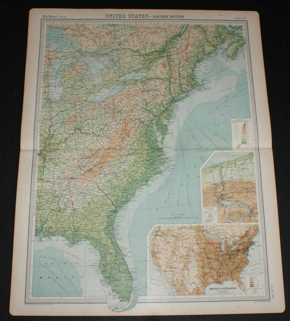
Title: Map of Eastern Section of United States from the 1920 Times Survey Atlas (Plate 90) including Michigan, Indiana, Ohio, Pennsylvania, New York, Maine, Virginia, Kentucky, North Carolina, Alabama, Georgia, Florida, Niagara Falls etc.
Description: Map The Times, London, 1920. First Edition, Softcover. Very Good Condition/No Dust Jacket. Disbound single sheet with horizontal centre fold from the 1920 "The Times Survey Atlas of the World". Map is in colour and suitable for framing. Colour on both land and sea according to contour. Map at scale 1:5,000,000. Map covers; Michigan, Indiana, Ohio, Pennsylvania, New York, Maine, Vermont, New Hampshire, Massachusetts, West Virginia, Kentucky, North and South Carolina, Alabama, Georgia, Florida, Nova Scotia, Lake Erie, Lake Ontario, Lake Michigan, Lake Huron, Boston, New York, Philadelphia, Montreal, Ottawa, etc. Sheet contains two inset maps; Niagara Falls and environs and Population Denisity for USA. Slightly darkened edges and occasional light foxing in margins but sheet is otherwise clean and crisp. Item Type: Map. Single sheet map/chart which is suitable for framing and will be shipped rolled and in a cardboard tube. Quantity Available: 1. Shipped Weight: under 1 kg. Pictures of this item not already displayed here available upon request. Inventory No: 45020034017. ISBN: 0850335086
Keywords: BZDB4 Maps; World History; USA & Canada. The Times and J. G. Bartholomew Map of Eastern Section of United States from the 1920 Times Survey Atlas (Plate 90) including Michigan, Indiana, Ohio, Pennsylvania, New York, Maine, Virginia, Kentucky, North Caroli
See more books from our catalog: Maps
Title: Map of Eastern Section of United States from the 1920 Times Survey Atlas (Plate 90) including Michigan, Indiana, Ohio, Pennsylvania, New York, Maine, Virginia, Kentucky, North Carolina, Alabama, Georgia, Florida, Niagara Falls etc.
Description: Map The Times, London, 1920. First Edition, Softcover. Very Good Condition/No Dust Jacket. Disbound single sheet with horizontal centre fold from the 1920 "The Times Survey Atlas of the World". Map is in colour and suitable for framing. Colour on both land and sea according to contour. Map at scale 1:5,000,000. Map covers; Michigan, Indiana, Ohio, Pennsylvania, New York, Maine, Vermont, New Hampshire, Massachusetts, West Virginia, Kentucky, North and South Carolina, Alabama, Georgia, Florida, Nova Scotia, Lake Erie, Lake Ontario, Lake Michigan, Lake Huron, Boston, New York, Philadelphia, Montreal, Ottawa, etc. Sheet contains two inset maps; Niagara Falls and environs and Population Denisity for USA. Slightly darkened edges and occasional light foxing in margins but sheet is otherwise clean and crisp. Item Type: Map. Single sheet map/chart which is suitable for framing and will be shipped rolled and in a cardboard tube. Quantity Available: 1. Shipped Weight: under 1 kg. Pictures of this item not already displayed here available upon request. Inventory No: 45020034017. ISBN: 0850335086
Keywords: BZDB4 Maps; World History; USA & Canada. The Times and J. G. Bartholomew Map of Eastern Section of United States from the 1920 Times Survey Atlas (Plate 90) including Michigan, Indiana, Ohio, Pennsylvania, New York, Maine, Virginia, Kentucky, North Caroli
Price: GBP 24.00 = appr. US$ 34.27 Seller: Bailgate Books Ltd
- Book number: 45020034017
- Book number: 45020034017
See more books from our catalog: Maps