Author: The Times and J. G. Bartholomew
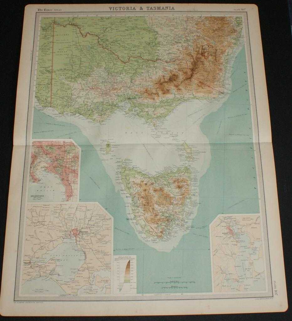
Title: Map of Victoria and Tasmania, Australia from the 1920 Times Survey Atlas (Plate 107) including inset maps of Melbourne and Hobart and environs
Description: Map The Times, London, 1920. First Edition, Softcover. Very Good Condition/No Dust Jacket. Disbound single sheet with horizontal centre fold from the 1920 "The Times Survey Atlas of the World". Map is in colour and suitable for framing. Colour on both land and sea according to contour. Map at scale 1:2,500,000 with insets of Melbourne and Hobart at larger scales and street plan of Melbourne at 1:150,0000. Area covered includes: Canberra, Cape Howe, Murray River, Furneaux Group, King Island, Bass Strait, Melbourne, Port Phillip Bay, Geelong, Discovery Bay, Horbart, Hunters Islands, Tasman's Peninsula, etc. Slightly darkened edges and very occasional foxing but sheet is otherwise clean and crisp. Item Type: Map. Single sheet map/chart which is suitable for framing and will be shipped rolled and in a cardboard tube. Quantity Available: 1. Shipped Weight: under 1 kg. Pictures of this item not already displayed here available upon request. Inventory No: 45020034006. ISBN: 0850335086
Keywords: BZDB4 Maps; naval, naval history, maritime, ships, boats; World History; Australasia and the Pacific. The Times and J. G. Bartholomew Map of Victoria and Tasmania, Australia from the 1920 Times Survey Atlas (Plate 107) including inset maps of Melbourne an
See more books from our catalog: Maps
Title: Map of Victoria and Tasmania, Australia from the 1920 Times Survey Atlas (Plate 107) including inset maps of Melbourne and Hobart and environs
Description: Map The Times, London, 1920. First Edition, Softcover. Very Good Condition/No Dust Jacket. Disbound single sheet with horizontal centre fold from the 1920 "The Times Survey Atlas of the World". Map is in colour and suitable for framing. Colour on both land and sea according to contour. Map at scale 1:2,500,000 with insets of Melbourne and Hobart at larger scales and street plan of Melbourne at 1:150,0000. Area covered includes: Canberra, Cape Howe, Murray River, Furneaux Group, King Island, Bass Strait, Melbourne, Port Phillip Bay, Geelong, Discovery Bay, Horbart, Hunters Islands, Tasman's Peninsula, etc. Slightly darkened edges and very occasional foxing but sheet is otherwise clean and crisp. Item Type: Map. Single sheet map/chart which is suitable for framing and will be shipped rolled and in a cardboard tube. Quantity Available: 1. Shipped Weight: under 1 kg. Pictures of this item not already displayed here available upon request. Inventory No: 45020034006. ISBN: 0850335086
Keywords: BZDB4 Maps; naval, naval history, maritime, ships, boats; World History; Australasia and the Pacific. The Times and J. G. Bartholomew Map of Victoria and Tasmania, Australia from the 1920 Times Survey Atlas (Plate 107) including inset maps of Melbourne an
Price: GBP 24.00 = appr. US$ 34.27 Seller: Bailgate Books Ltd
- Book number: 45020034006
- Book number: 45020034006
See more books from our catalog: Maps