Author: The Times and J. G. Bartholomew
Title: Map of New South Wales, Australia from the 1920 Times Survey Atlas (Plate 108) including inset maps of Canberra and Sydney and environs
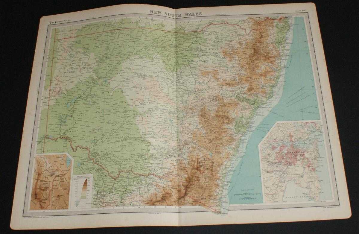
Description: Map The Times, London, 1920. First Edition, Softcover. Very Good Condition/No Dust Jacket. Disbound single sheet with vertical centre fold from the 1920 "The Times Survey Atlas of the World". Map is in colour and suitable for framing. Colour on both land and sea according to contour. Map at scale 1:2,500,000 with inset of Canberra at 1:1,000,000 and street plan of Sydney at 1:150,000. Area covered includes: Sydney, Port Jackson, Byron Bay, Sugarloaf Point, Newcastle, Cape Howe, Darling River, Grey Range, Barrier or Stanley Range, Bendigo, Canberra, etc. Slightly darkened edges and very occasional foxing but sheet is otherwise clean and crisp. Item Type: Map. Single sheet map/chart which is suitable for framing and will be shipped rolled and in a cardboard tube. Quantity Available: 1. Shipped Weight: under 1 kg. Pictures of this item not already displayed here available upon request. Inventory No: 45020034005. ISBN: 0850335086
Keywords: BZDB4 Maps; naval, naval history, maritime, ships, boats; World History; Australasia and the Pacific. The Times and J. G. Bartholomew Map of New South Wales, Australia from the 1920 Times Survey Atlas (Plate 108) including inset maps of Canberra and Sydne
See more books from our catalog: Maps
Title: Map of New South Wales, Australia from the 1920 Times Survey Atlas (Plate 108) including inset maps of Canberra and Sydney and environs
Description: Map The Times, London, 1920. First Edition, Softcover. Very Good Condition/No Dust Jacket. Disbound single sheet with vertical centre fold from the 1920 "The Times Survey Atlas of the World". Map is in colour and suitable for framing. Colour on both land and sea according to contour. Map at scale 1:2,500,000 with inset of Canberra at 1:1,000,000 and street plan of Sydney at 1:150,000. Area covered includes: Sydney, Port Jackson, Byron Bay, Sugarloaf Point, Newcastle, Cape Howe, Darling River, Grey Range, Barrier or Stanley Range, Bendigo, Canberra, etc. Slightly darkened edges and very occasional foxing but sheet is otherwise clean and crisp. Item Type: Map. Single sheet map/chart which is suitable for framing and will be shipped rolled and in a cardboard tube. Quantity Available: 1. Shipped Weight: under 1 kg. Pictures of this item not already displayed here available upon request. Inventory No: 45020034005. ISBN: 0850335086
Keywords: BZDB4 Maps; naval, naval history, maritime, ships, boats; World History; Australasia and the Pacific. The Times and J. G. Bartholomew Map of New South Wales, Australia from the 1920 Times Survey Atlas (Plate 108) including inset maps of Canberra and Sydne
Price: GBP 26.00 = appr. US$ 37.13 Seller: Bailgate Books Ltd
- Book number: 45020034005
- Book number: 45020034005
See more books from our catalog: Maps