Author: Pigot & Co
Title: 1839 Map of the County of Buckinghamshire - taken from Pigot and Co's British Atlas Comprising the Counties of England (upon which are laid down all railways completed and in progress)
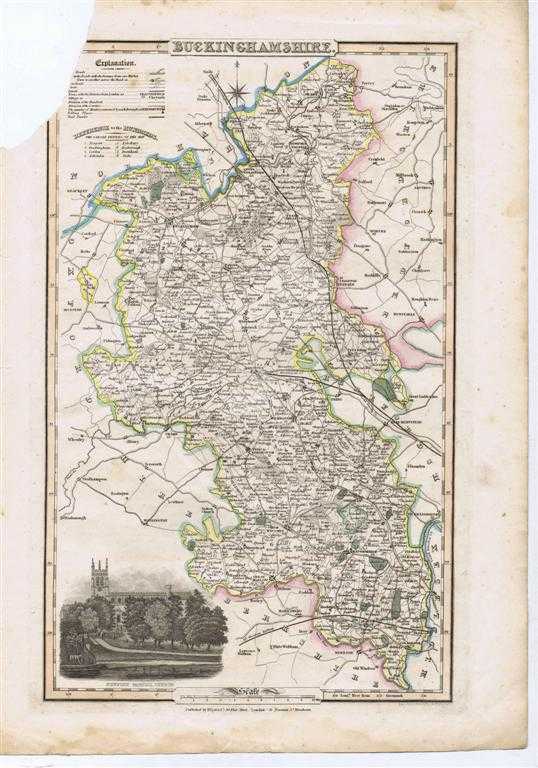
Description: Map Pigot and Co, London and Manchester, London and Manchester, 1839. Edition Unstated, Disbound. Fair/No Dust Jacket. Dated from reference to British Library catelogue and title-page of atlas. This is the coloured map titled "Buckinghamshire" and sheet also titled "Buckinghamshire". The map, a hand-coloured (prior to initial binding) steel engraving contains a vignette of Newport Pagnall Church. The inner side of the Buckinghamshire county boundary is coloured yellow, inner boundaries of adjacent counties Bedfordshire, Hertfordshire, Middlesex, Berkshire, Oxfordshire and Northamptonshire are coloured pale green, blue or pink. Wooded areas and rough ground are indicated. Country estates are coloured dark green and include: Stow Park, Bulrode Park, Langley Park, Wilton Park and Stoke Park. The map shows cities, market towns, villages and hamlets, the distance between the towns and cities and London is shown, also shown are the numbers of members returned for each borough and polling places. Towns shown include: Aylesbury, Beaconsfiled, Buckingham, Cesham, Fenny Stratford, Ivinghoe, Kaarlow, Newport Pagnell, Olney, Princes Risborough, Stony Stratford, Wendover, Winslow, and High Wycombe, distances between these towns are given in a table on the accompanying sheet. Mail roads, Turnpike roads, cross Roads, lanes and other minor routes are shown with distances marked between Market Towns on the Turnpike Roads. Railways, rivers and canals are shown, including the London and Birmingham Railway with a branch line to Aylesbury, the Great Western Railway and the Grand Junction Canal with the Collateral Cut to Aylesbury, and the cut to Wendover. Mail and Turnpike roads and towns and principal villages in the neighbouring parts of adjacent counties are also shown. The boundaries of the "Hundreds" are shown and the names of each Hundred are identified in the key. The border includes longitude and latitude references and the scale is given in the bottom border which for this map is 2.875 inches to 10 miles. The map is a little darkened but otherwise clean but is missing the top left corner. This loss of this triangular piece (approx 4 cm across and 6cm deep) encroaches onto the coloured border and top corner of the key to the map, the loss within the coloured boarder is a triangular piece approx 1.5 cm by 3cm. The printed accompanying sheet is also missing the top left corner (similar size loss), text loss is restricted to the first letter of the text. Item Type: Map. Quantity Available: 1. Shipped Weight: under 1 kg. Pictures of this item not already displayed here available upon request. Inventory No: 45012040117. ISBN: 0727806556
Keywords: BZDB4 , Buckinghamshire, county map London & the South East; England; Maps. Pigot & Co 1839 Map of the County of Buckinghamshire - taken from Pigot and Co's British Atlas Comprising the Counties of England (upon which are laid down all railways completed
See more books from our catalog: London & the South East
Title: 1839 Map of the County of Buckinghamshire - taken from Pigot and Co's British Atlas Comprising the Counties of England (upon which are laid down all railways completed and in progress)
Description: Map Pigot and Co, London and Manchester, London and Manchester, 1839. Edition Unstated, Disbound. Fair/No Dust Jacket. Dated from reference to British Library catelogue and title-page of atlas. This is the coloured map titled "Buckinghamshire" and sheet also titled "Buckinghamshire". The map, a hand-coloured (prior to initial binding) steel engraving contains a vignette of Newport Pagnall Church. The inner side of the Buckinghamshire county boundary is coloured yellow, inner boundaries of adjacent counties Bedfordshire, Hertfordshire, Middlesex, Berkshire, Oxfordshire and Northamptonshire are coloured pale green, blue or pink. Wooded areas and rough ground are indicated. Country estates are coloured dark green and include: Stow Park, Bulrode Park, Langley Park, Wilton Park and Stoke Park. The map shows cities, market towns, villages and hamlets, the distance between the towns and cities and London is shown, also shown are the numbers of members returned for each borough and polling places. Towns shown include: Aylesbury, Beaconsfiled, Buckingham, Cesham, Fenny Stratford, Ivinghoe, Kaarlow, Newport Pagnell, Olney, Princes Risborough, Stony Stratford, Wendover, Winslow, and High Wycombe, distances between these towns are given in a table on the accompanying sheet. Mail roads, Turnpike roads, cross Roads, lanes and other minor routes are shown with distances marked between Market Towns on the Turnpike Roads. Railways, rivers and canals are shown, including the London and Birmingham Railway with a branch line to Aylesbury, the Great Western Railway and the Grand Junction Canal with the Collateral Cut to Aylesbury, and the cut to Wendover. Mail and Turnpike roads and towns and principal villages in the neighbouring parts of adjacent counties are also shown. The boundaries of the "Hundreds" are shown and the names of each Hundred are identified in the key. The border includes longitude and latitude references and the scale is given in the bottom border which for this map is 2.875 inches to 10 miles. The map is a little darkened but otherwise clean but is missing the top left corner. This loss of this triangular piece (approx 4 cm across and 6cm deep) encroaches onto the coloured border and top corner of the key to the map, the loss within the coloured boarder is a triangular piece approx 1.5 cm by 3cm. The printed accompanying sheet is also missing the top left corner (similar size loss), text loss is restricted to the first letter of the text. Item Type: Map. Quantity Available: 1. Shipped Weight: under 1 kg. Pictures of this item not already displayed here available upon request. Inventory No: 45012040117. ISBN: 0727806556
Keywords: BZDB4 , Buckinghamshire, county map London & the South East; England; Maps. Pigot & Co 1839 Map of the County of Buckinghamshire - taken from Pigot and Co's British Atlas Comprising the Counties of England (upon which are laid down all railways completed
Price: GBP 18.00 = appr. US$ 25.70 Seller: Bailgate Books Ltd
- Book number: 45012040117
- Book number: 45012040117
See more books from our catalog: London & the South East